
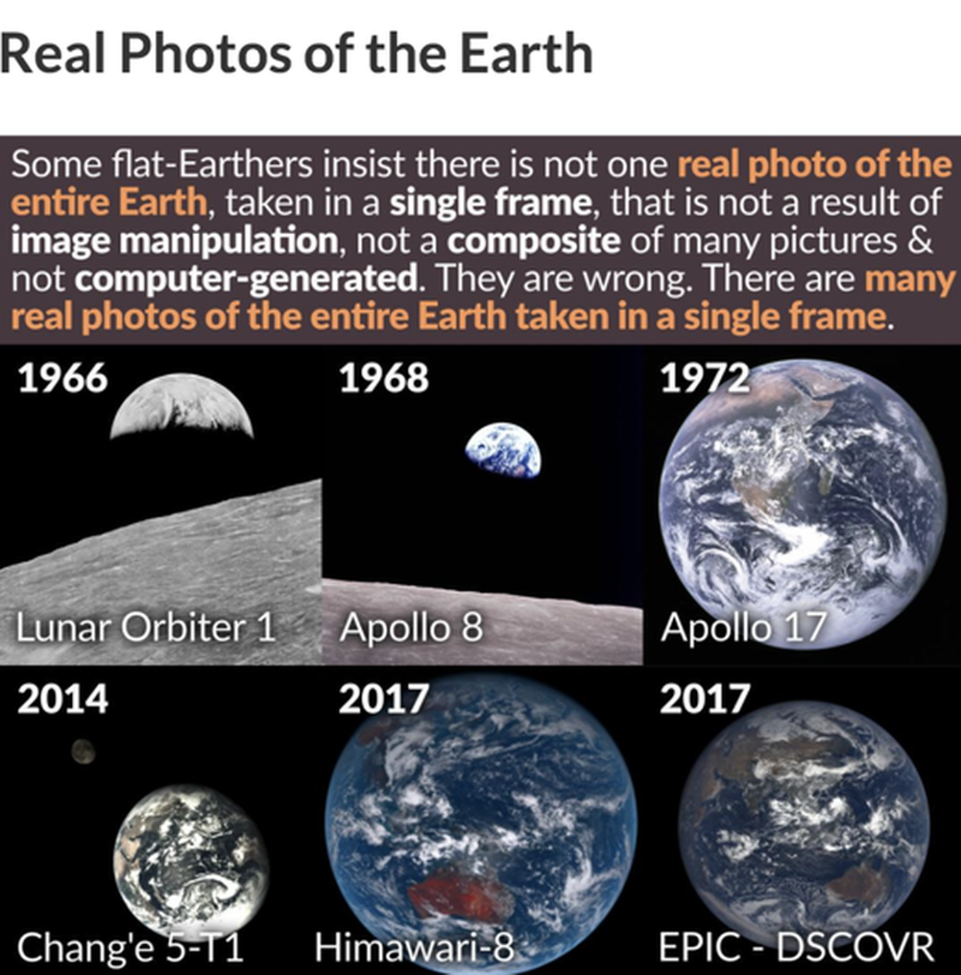
Full Earth Images from Space Taken Daily - HUNDREDS!
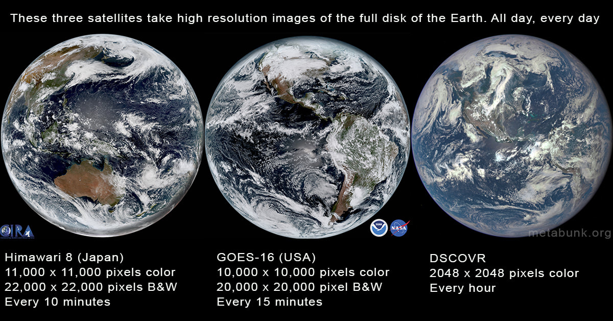
There are several satellites that take photos of the full disk of the earth on a regular basis, but the most impressive are the three above. The first two (Himawari-8 and GOES-16) are geostationary satellites taking photos from 22,236 miles above the Earth's equator. The third, DSCOVR is located in an orbit between the Earth and the Sun, about one million miles away. All three take several photos a day
USA: GOES 16 & 17 (RAMMB/CIRA SLIDER) (Zoomable, HD) , NEXLAB, NOAA Full Resolution (17)
Japan: Himawari-8 (JME), RAMDIS Feeds , JME Feed (11K), NICT zoomable archive (best).
USA: DSCOVR (L1) (Full disk rotating Earth from a fixed relative point)
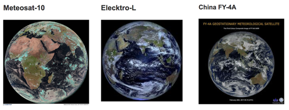
Europe: Meteosat-10 (11K), Historical Viewer (slow)
India: INSAT
Russia: Elektro-L (11K) (Ntsomz interactive view and download) (FTP Archive)
China FY-4A
There are several satellites that take photos of the full disk of the earth on a regular basis, but the most impressive are the three above. The first two (Himawari-8 and GOES-16) are geostationary satellites taking photos from 22,236 miles above the Earth's equator. The third, DSCOVR is located in an orbit between the Earth and the Sun, about one million miles away. All three take several photos a day
USA: GOES 16 & 17 (RAMMB/CIRA SLIDER) (Zoomable, HD) , NEXLAB, NOAA Full Resolution (17)
Japan: Himawari-8 (JME), RAMDIS Feeds , JME Feed (11K), NICT zoomable archive (best).
USA: DSCOVR (L1) (Full disk rotating Earth from a fixed relative point)
Europe: Meteosat-10 (11K), Historical Viewer (slow)
India: INSAT
Russia: Elektro-L (11K) (Ntsomz interactive view and download) (FTP Archive)
China FY-4A
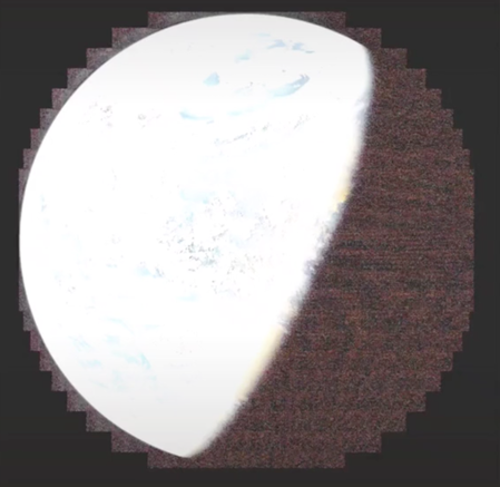
DSCOVR (roughly 930,000 miles away)
DSCOVR lacks the high resolution of Himawari-8 and GOES-16, but more than makes up for it with it's unique position in space. It's orbiting a point between the Earth and the Sun called a Lagrange point, where the combined gravitational and centrifugal forces balance out to keep it in place between the Earth and the Sun
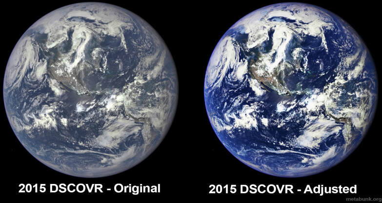
The contrast color saturation is something you can arbitrarily pick after the raw image is created. Most consumer cameras boost this to make the images look better, but the more washed out image is the more realistic. Here, for example, I've adjusted the contrast and saturation of the 2015 DSCOVR image:
DSCOVR lacks the high resolution of Himawari-8 and GOES-16, but more than makes up for it with it's unique position in space. It's orbiting a point between the Earth and the Sun called a Lagrange point, where the combined gravitational and centrifugal forces balance out to keep it in place between the Earth and the Sun
The contrast color saturation is something you can arbitrarily pick after the raw image is created. Most consumer cameras boost this to make the images look better, but the more washed out image is the more realistic. Here, for example, I've adjusted the contrast and saturation of the 2015 DSCOVR image:
But it takes an image ever hour (in 10 spectra) and you can watch a full year timelapse:
Click on Below (only 2 - 1/2 minutes).
Click on Below (only 2 - 1/2 minutes).
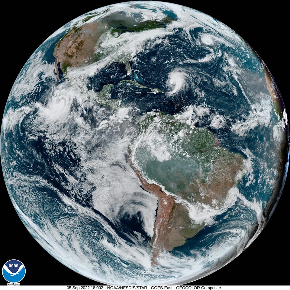
GOES-16 satellite
WHOLE EARTH Image of the Earth taken recentlyby GOES-16 satellite
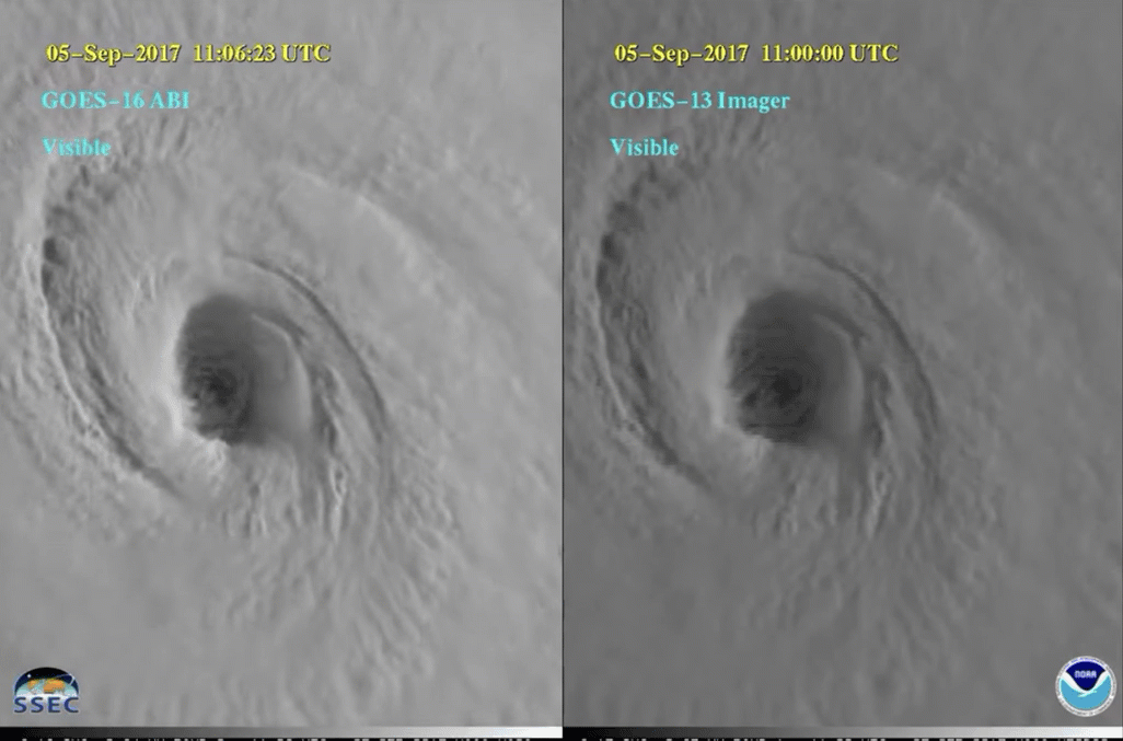
GOES-16 Is basically NASA's version of Himawari-8. Like the Himawari series, the GOES series have all been weather satellites. Their primary mission is helping forecast the weather, so up until now they have just given black and white images (one visible wavelength, and several infrared wavelengths). GOES satellites have actually been taking full disk images for many years, but GOES-16 is by far the best, with a higher resolution camera, and color. Here's a comparison of GOES-16 and GOES-13 taken at about the same time. Notice the position is different, GOES-16 being further west than GOES-13
WHOLE EARTH Image of the Earth taken recentlyby GOES-16 satellite
GOES-16 Is basically NASA's version of Himawari-8. Like the Himawari series, the GOES series have all been weather satellites. Their primary mission is helping forecast the weather, so up until now they have just given black and white images (one visible wavelength, and several infrared wavelengths). GOES satellites have actually been taking full disk images for many years, but GOES-16 is by far the best, with a higher resolution camera, and color. Here's a comparison of GOES-16 and GOES-13 taken at about the same time. Notice the position is different, GOES-16 being further west than GOES-13
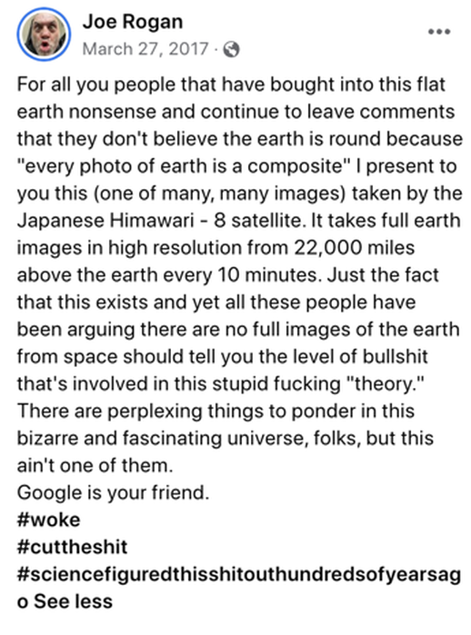
Joe Rogan gets it!
The Himawari 8 is a Flat Earth Killer (as is GOES-16)!
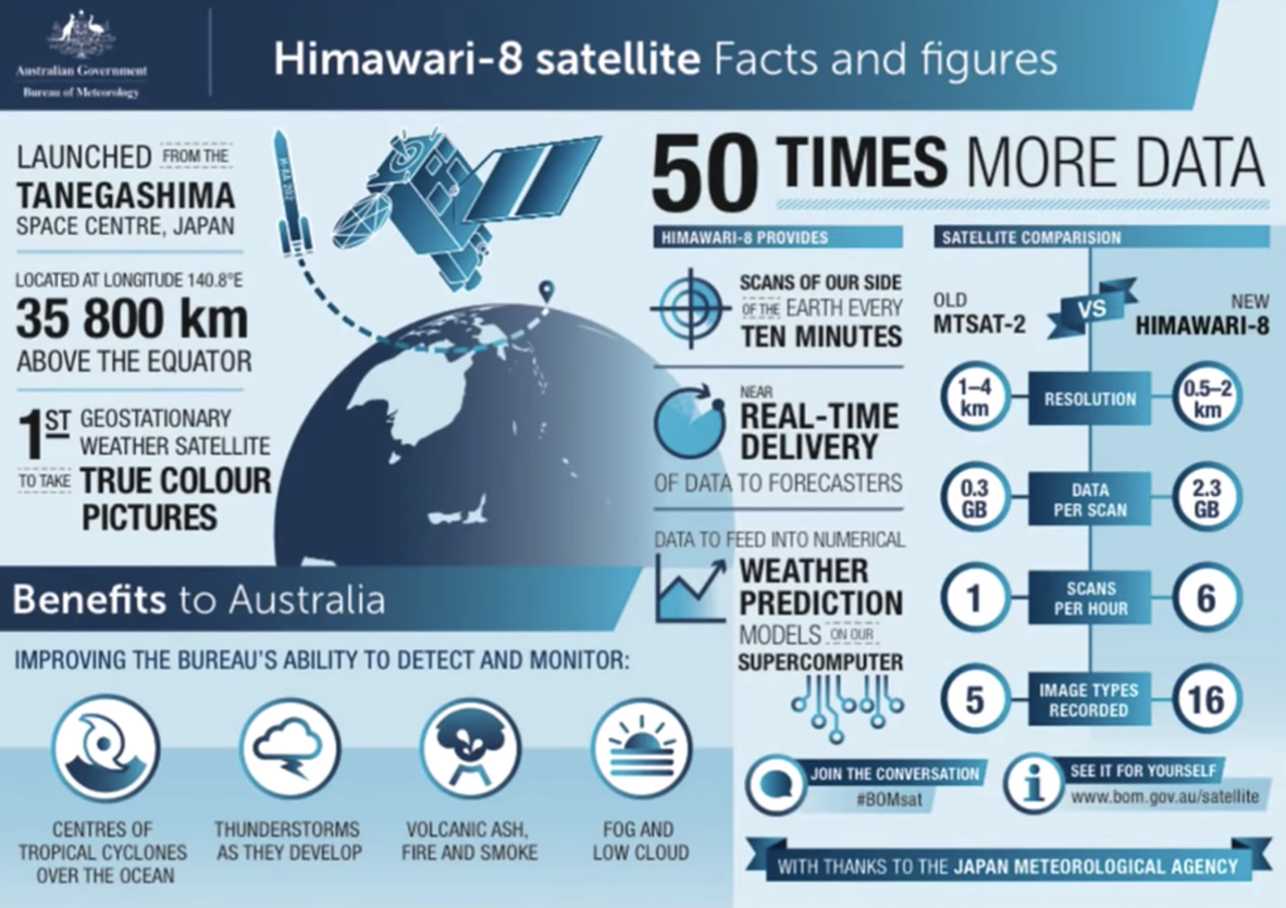
Himawari-8 weather satellite (22,000 miles away) - 11K resolution!
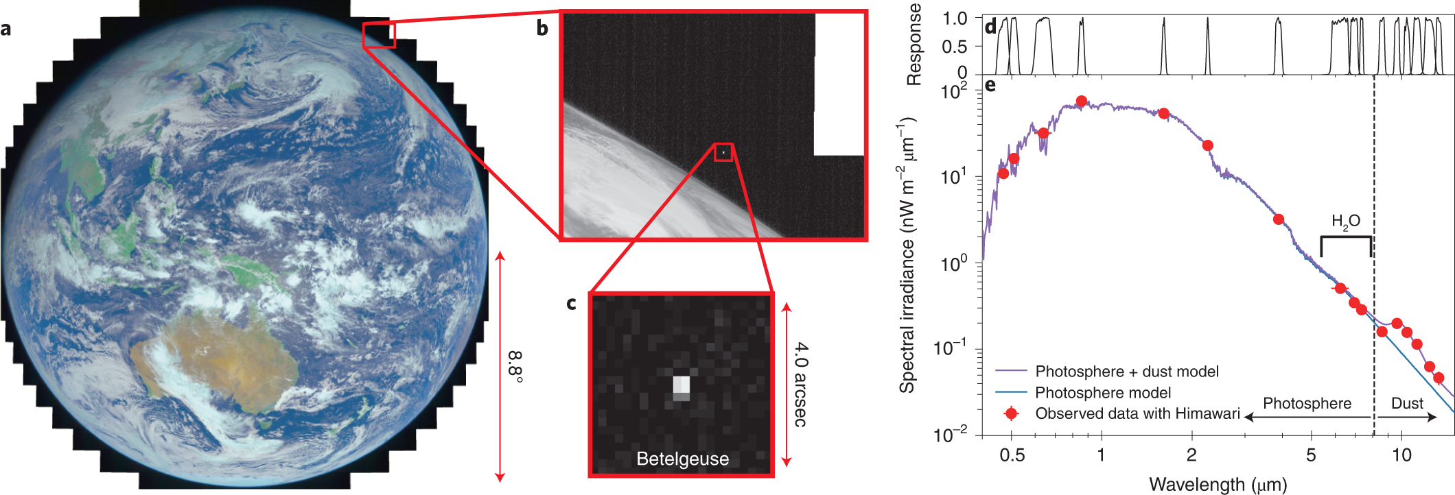
Himawari-8 is a Japanese weather satellite, and so is in orbit over the Equator with a good view of Japan. It is remarkably high resolution, producing images 11,000 pixels square (121 Megapixels), and in color. It can go up to 22,000 pixels (484 megapixels) in B&W (using just the red wavelength of light)
Its considerable distance from Earth isn’t necessarily surprising; most weather satellites do their work in high earth orbit. But what makes Himawari-8 unique among its colleagues is the fact that it is capable of taking full-color photos of the entire planet. Every day, it sends 144 of these “living portraits” back down to Earth – or one photograph every ten minutes.
REAL TIME PHOTOS OF EASTERN HEMISPHERE. With an unprecedentedly high resolution that can visualize features as small as 500 square meters!
https://himawari8.nict.go.jp/
The Himawari 8 is a Flat Earth Killer (as is GOES-16)!
Himawari-8 weather satellite (22,000 miles away) - 11K resolution!
Himawari-8 is a Japanese weather satellite, and so is in orbit over the Equator with a good view of Japan. It is remarkably high resolution, producing images 11,000 pixels square (121 Megapixels), and in color. It can go up to 22,000 pixels (484 megapixels) in B&W (using just the red wavelength of light)
Its considerable distance from Earth isn’t necessarily surprising; most weather satellites do their work in high earth orbit. But what makes Himawari-8 unique among its colleagues is the fact that it is capable of taking full-color photos of the entire planet. Every day, it sends 144 of these “living portraits” back down to Earth – or one photograph every ten minutes.
REAL TIME PHOTOS OF EASTERN HEMISPHERE. With an unprecedentedly high resolution that can visualize features as small as 500 square meters!
https://himawari8.nict.go.jp/
|

|
Truth Observations
Ground truth observations will be a dagger in the flat earth!
The idea that all this data is faked and yet matches actual weather patterns is just ridiculous.
The idea that all this data is faked and yet matches actual weather patterns is just ridiculous. The idea that somehow ground doppler radar can produce 11K images is Ludicrous. That is NOT how doppler works!!
The idea that all of these are simple photoshop images or even the idea that there are millions of planes and balloons scouring the Earth every minute of the day and night so we get accurate image data we can render into globes is just absurd.
Or I have heard some flat earthers say it is doppler radar at ground level recreating them. CLEARLY THEY DON'T UNDERSTAND DOPPLER RADAR!
Lunar Eclipses
Dust Clouds
Volcanos
Aurora Borealis
Bush Fires china and australia
Floods / Track Flood Water
Look at some of the brief video clips below of lunar eclipse shadows right on schedule, fires in Australia and China that were caught on Himawari and saved lives (doppler cannot get this), just clouds, volcanos, floods and Aurora Borealis, all things GROUND DOPPLER CANNOT CAPTURE.
The Himawari-8 is a flat earth KILLER (as is GOES-16, DISCVR, ELECKTRO-L, METEOSAT and others.
Ground Truth Confirmation
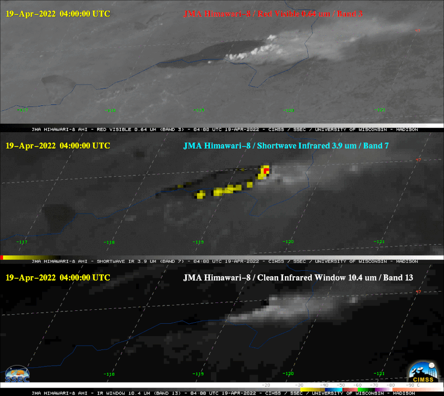
Himawari-8 Satellite Based Dynamic Monitoring of Grassland Fire in China-Mongolia Border Regions
https://www.ncbi.nlm.nih.gov/pmc/articles/PMC5795838/
2015 wildfire on China Mongolia border
From the Himawari 8 they were able to track and predict the
Path of the wildfire and save lives.
Himawari-8 Satellite Based Dynamic Monitoring of Grassland Fire in China-Mongolia Border Regions
https://www.ncbi.nlm.nih.gov/pmc/articles/PMC5795838/
2015 wildfire on China Mongolia border
From the Himawari 8 they were able to track and predict the
Path of the wildfire and save lives.
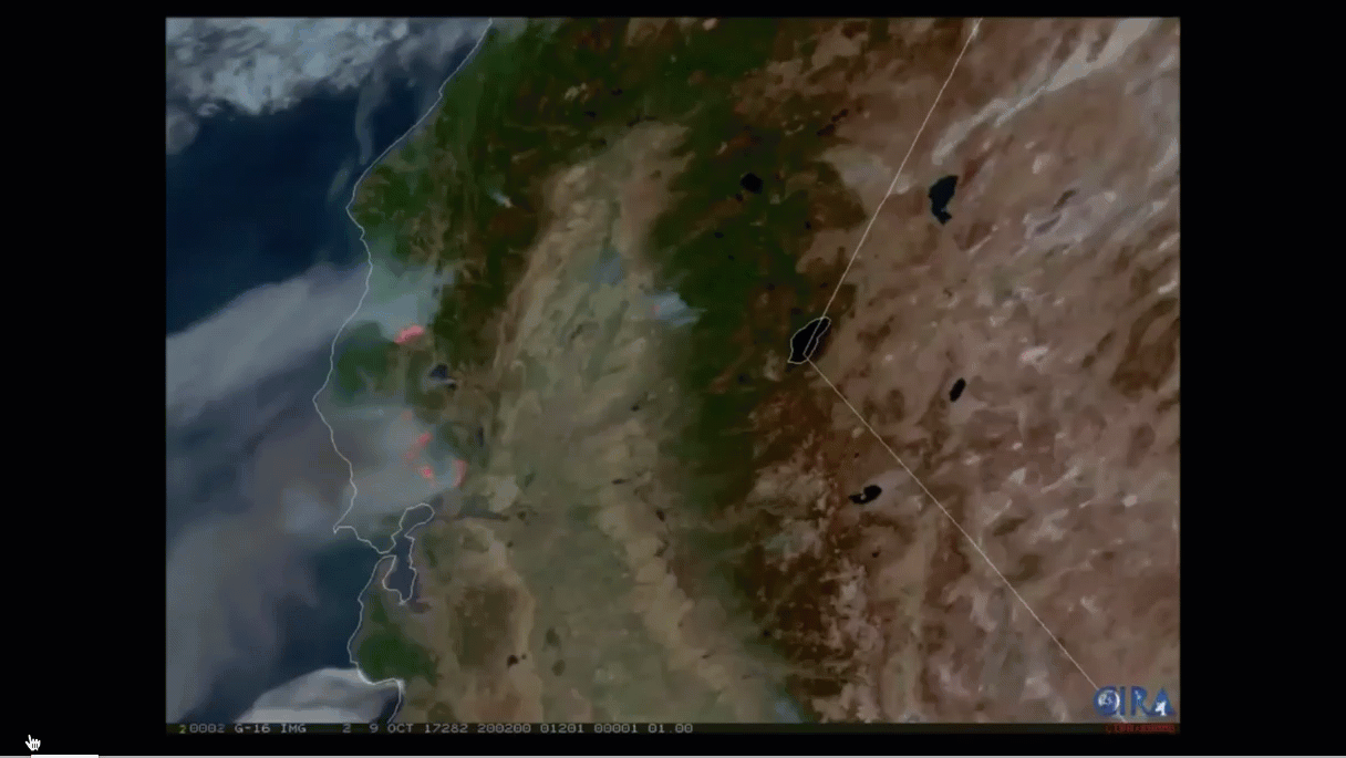
This sequence shows wildfires from Northern California from 2017 from GOES-16
Tracking Hurricanes
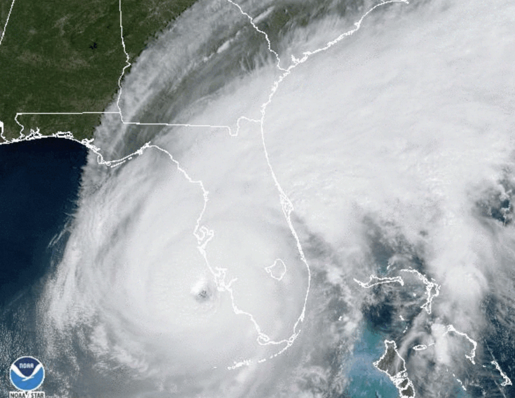
Hurricanes - Living in Florida for 15 years I have been involved with two Major Hurricanes, Hurricane Irma and Hurricane Ian. Being in a flood zone, I fled Florida from Hurricane Irma but I witnessed its devastation when I got back. Very recently I actually endured Hurricane Ian close to my house but in a well protected structure that was not in a flood zone. I watched hurricane Ian from GOES-16 very regularly and was amazing at the size and power of the storm, and amazed also at how high resolution these GOES-16 images were.
Hurricane Irma on Left, Hurricane Ian on Right as it makes landfall and devastates Ft Myers and surrounding area. I was kinda lucky to be JUST BARELY north enough not to get devastating winds, but still A LOT of damage!
Solar Eclipse from Himawari
University of Wisconsin Madison put together this video of an eclipse passing over the continental U.S. (Below).
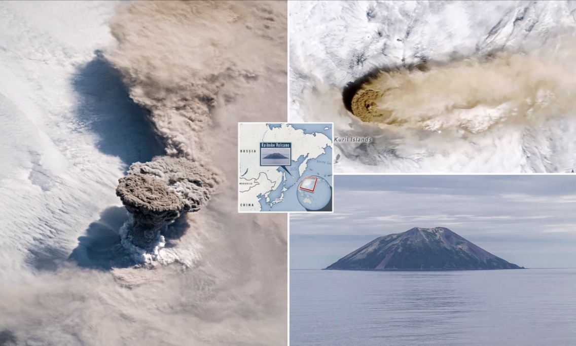
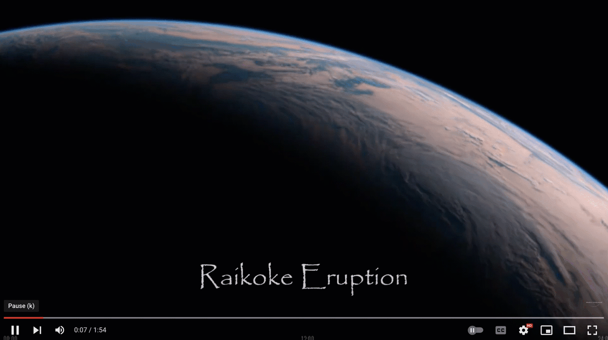
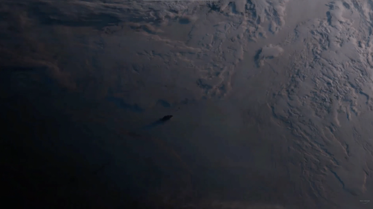
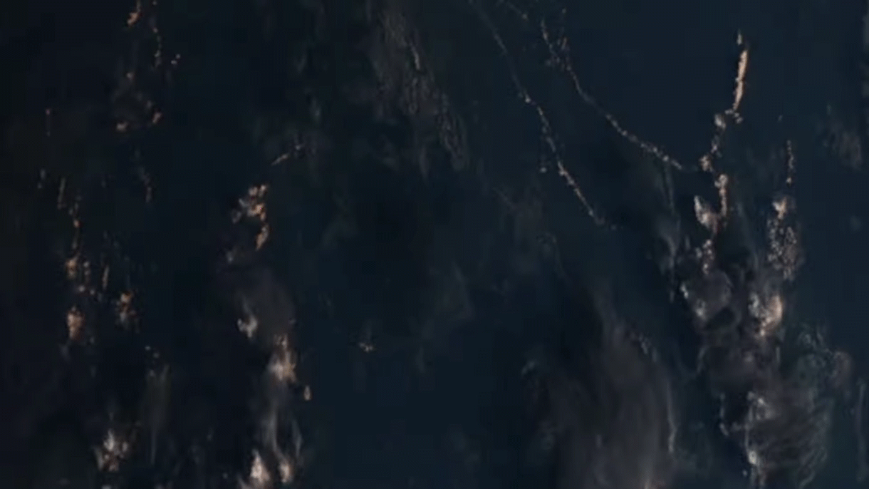
RAIKOKE VOLCANIC Eruption seen from Space 🌋 Himawari 8 & the ISS
Eruption of Mt Sinabung in Indonesia from Himawara 8
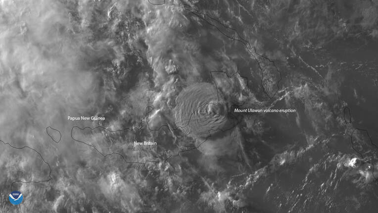
Himawari-8 Sees Volcanic Cloud from Mt. Ulawun Eruption
About 5,000 people in June 2019 were forced to flee their homes Wednesday, June 26, 2019, when Mount Ulawun on the island of New Britain in Papua New Guinea erupted. Himawari-8 saw this volcanic cloud, which reached a maximum height of 22 kilometers or more than 13 miles,
About 5,000 people in June 2019 were forced to flee their homes Wednesday, June 26, 2019, when Mount Ulawun on the island of New Britain in Papua New Guinea erupted. Himawari-8 saw this volcanic cloud, which reached a maximum height of 22 kilometers or more than 13 miles,
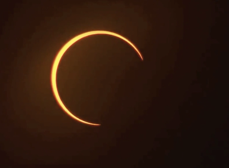
Annular Solar Eclipse “Ring of Fire” seen from space | Himawari 8
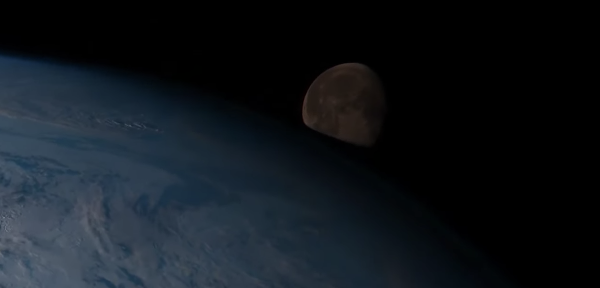
Sun Flat Earthers Complain the Himawari 8 and others doesn't see the moon. They are WRONG. The moon is ONLY seen very close to the earth because of the way the Himawari 8 sweeps and scans the earth.

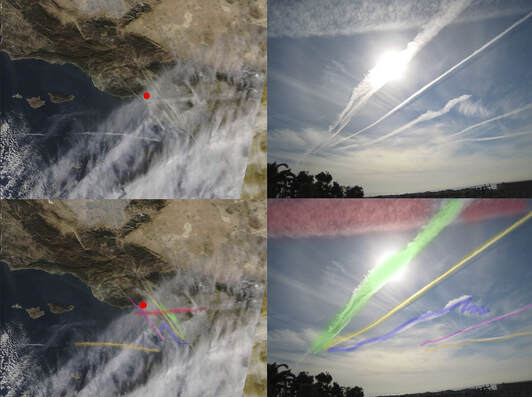
FLAT EARTH debunked by HIMAWARI 8 ground observationsAn observation Wade's Underground did matching his local weather with images from Himawari 8.
The popular flat earth argument that satellites images are cgi or fake or doppler is completely debunked by this observation. Matching satellite images with ground based observations.
The popular flat earth argument that satellites images are cgi or fake or doppler is completely debunked by this observation. Matching satellite images with ground based observations.
Ground Truth Confirmation
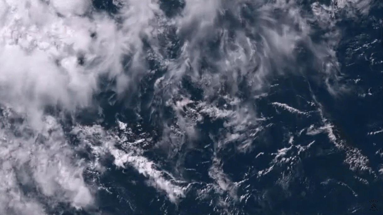
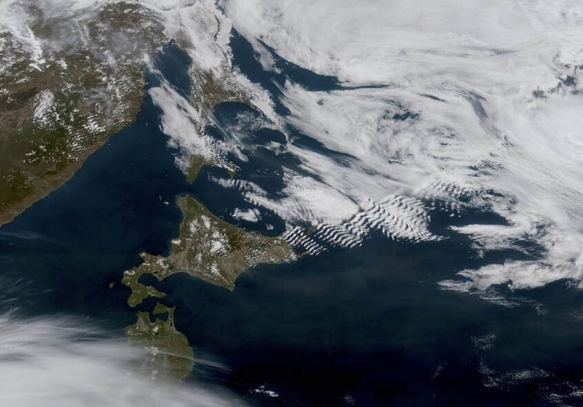
If you zoom in you can see detailed cloud patterns like these over Japan. The resolution is high enough that you can match up the clouds with the ground truth observations of the same clouds viewed from the ground
If you zoom in you can see detailed cloud patterns like these over Japan. The resolution is high enough that you can match up the clouds with the ground truth observations of the same clouds viewed from the ground
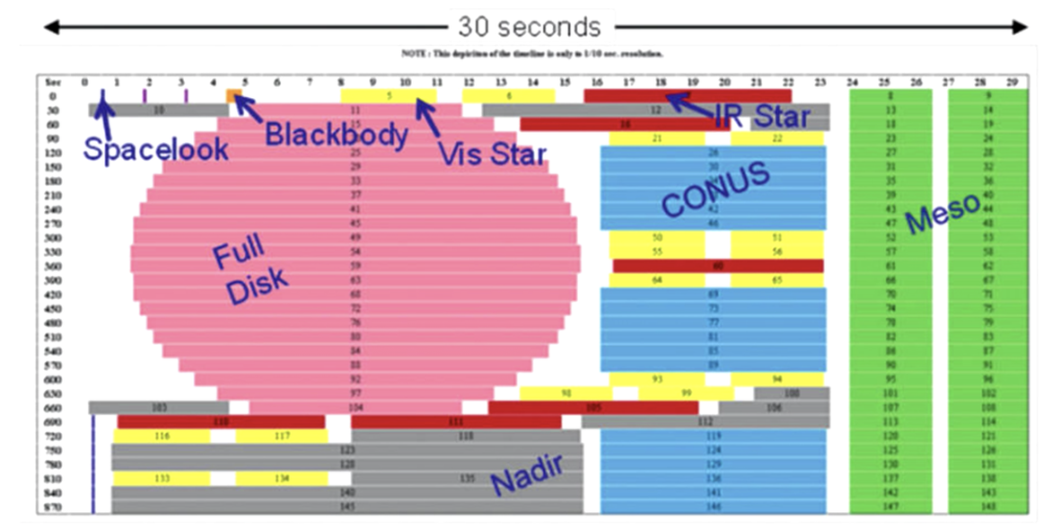
Himawari-8 (10 minutes)
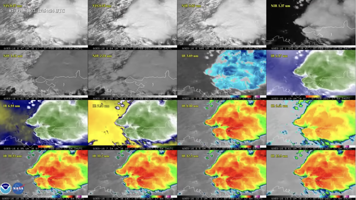
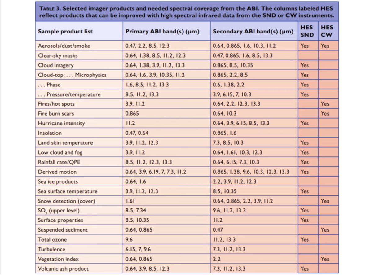
Advanced baseline imager, imaging in 16 different bands and the resolution of the image depends upon the bands.
1/2 kilometer to 2 kilometers.
Doing this all in 10 minutes.
U.S. GOES-16 (15 Minutes)
U.S. satellites are doing the imaging a little different, so it gives the GOES an extra 5 minutes to scan the internal continental U.S. at a higher temporal frequency.
For more detail on cloud motions.
Can also scan 2 storms.
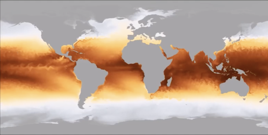
In the daytime you can see the full color globe but at night you can still see the clouds because it is using infrared cameras at night. These are overlaid upon blue marble.
You also see a flicker around midnight where the camera is pointing to the sun
Advanced baseline imager, imaging in 16 different bands and the resolution of the image depends upon the bands.
1/2 kilometer to 2 kilometers.
Doing this all in 10 minutes.
U.S. GOES-16 (15 Minutes)
U.S. satellites are doing the imaging a little different, so it gives the GOES an extra 5 minutes to scan the internal continental U.S. at a higher temporal frequency.
For more detail on cloud motions.
Can also scan 2 storms.
In the daytime you can see the full color globe but at night you can still see the clouds because it is using infrared cameras at night. These are overlaid upon blue marble.
You also see a flicker around midnight where the camera is pointing to the sun

Imaging timetable that shows you all the observations that go on in that 15 minute window.
|
|
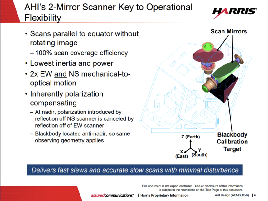
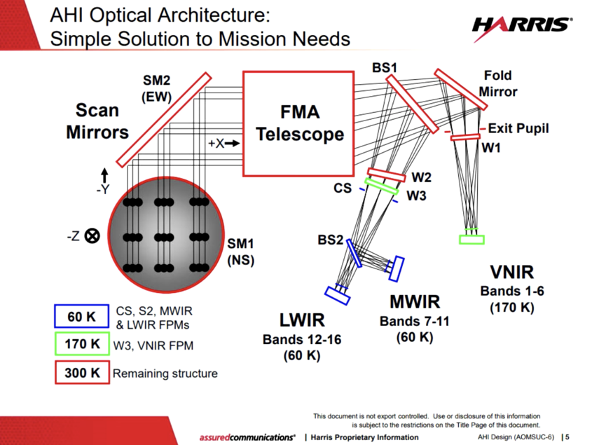
The actual scanning is performed by two different mirrors, one moves in the North to South axis and the other moves east to west.
Then that light is focused by a 4 mirror telescope and finally split over to 3 different camera systems using a pair of beam splitters.
Then that light is focused by a 4 mirror telescope and finally split over to 3 different camera systems using a pair of beam splitters.
|
|
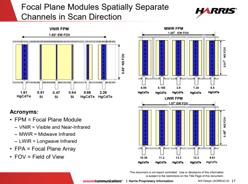
The cameras themselves are linear imagers, they are being scanned across the target and that is how you build a 2D image. There are different filters over different segments that each have their different band pass and of course all of these 16 different band passes are all optimized to do different things.
Because while we can appreciate this pictures for their beauty these are actually meteorological satellites!
The data that comes down is important for predicting weather and other things.
Because while we can appreciate this pictures for their beauty these are actually meteorological satellites!
The data that comes down is important for predicting weather and other things.
|
|
Flat Earth Objections -
You would think this is a nail in the coffin on flat earth, and well .... IT IS!
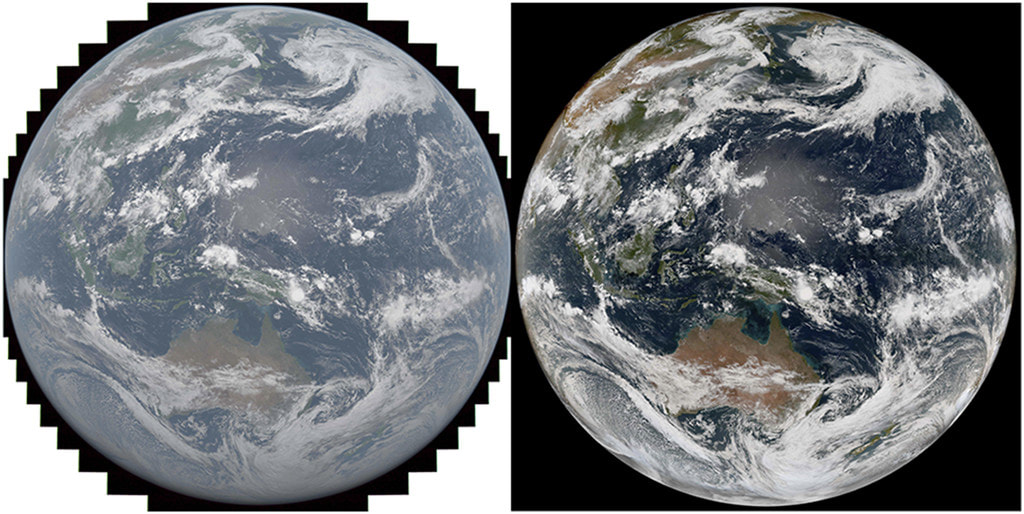
JMA not NASA
Blue marble data set is a collection of data taken from multiple polar orbiting satellites around the globe.
But as always flat earthers get together and try to come up with excupes and pseudoscience rationale for how these are fake images.
Initially flat earthers just said it was all CGI, but THEN way too many truth confirmations poured in from around the globe so they knew they needed to cough up a better pseudoscience rebuttal.
From my investigation they use two main excuses:
1) Images come from high altitude weather balloons
2) Images come from doppler radar.
3) Weather Simulation Software
Climate Simulation Software - not accurate and sure cannot predict the cloud cover of an area at a certain time.
Temperature prediction for future, not cloud cover or weather prediction.
Perfect accuracy of where the clouds.
But our friend here seems to think that annual globe temperature simulations somehow translate to daily cloud cover simulations through some means which he does not deign to expound upon.
You would think this is a nail in the coffin on flat earth, and well .... IT IS!
JMA not NASA
Blue marble data set is a collection of data taken from multiple polar orbiting satellites around the globe.
But as always flat earthers get together and try to come up with excupes and pseudoscience rationale for how these are fake images.
Initially flat earthers just said it was all CGI, but THEN way too many truth confirmations poured in from around the globe so they knew they needed to cough up a better pseudoscience rebuttal.
From my investigation they use two main excuses:
1) Images come from high altitude weather balloons
2) Images come from doppler radar.
3) Weather Simulation Software
Climate Simulation Software - not accurate and sure cannot predict the cloud cover of an area at a certain time.
Temperature prediction for future, not cloud cover or weather prediction.
Perfect accuracy of where the clouds.
But our friend here seems to think that annual globe temperature simulations somehow translate to daily cloud cover simulations through some means which he does not deign to expound upon.
Impossible to use ground based systems to cover the vast oceans.
Weather over oceans software simulations?? Huh?
For weather over the land...The NOAA has supercomputers taking data coming in from over the land from Doppler radar feeds and coming it with weather simulation software over the oceans to come up with a complete composite doppler map.
Doppler radar does not show clouds, it only shows rain and pressure changes. It does not show cloud cover.
Cloudy day sometimes and no red or green spots on doppler radar in your area.
Composite images like this.
So what flat earthers are saying is that someone NOAA takes doppler radar which does not actually see cloud cover and mixing it with global prediction for temperature changes and weather simulation, that are not entirely accurate and they also do not measure cloud cover and put it together and we get global cloud cover??
This image is using light that is not available to our eyes.
Having that weather data is only possible from space.
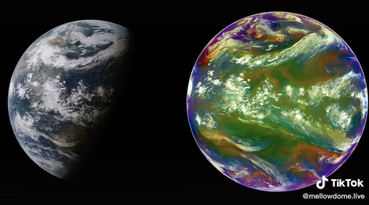
It is not simply a photo. It is several photos in different wavelengths calibrated to detect different things. The objective of the Himawari mission is not to prove that the earth is round, but to detect weather phenomena, smoke, &c.
On the side that is dark, there is still weather patterns.
Blue marble data set is taken from multiple orbiting satellites around the globe.
On the Himawari website they overlay cloud cover imagery based on infrared (which you can see in the dark) over a static globe image for reference. Of course, in order to accurately sense the cloud cover of the entire visible globe at night, you need a sensor up there in space to do it. Having accurate global data on a near-real time basis like this, proves that we have the sensors required to do it. Himawari proven.
==
Himawari 8
No Wrong- That is a reference to imagery for modelling purposes and promotional images.
The main instrument on Himawari8 is Advanced Himawari Imager (AHI). GOES is a different satellite and uses a different system so they may actually ovelay weather information over a earth model. Himawari8 does not.
So your assertion is that they overlay all of this every 10 minutes, citation needed.
Also an ftp site may have images they use for a variety of websites and models for other reasons. There's no reference to them using these images with the AHI.
Also the AHI is capable of Infra Red imagery. so that is how they can view the weather on the other side of the terminator line.
Love your assertions...again citations please.
=====
I watched the video and went to the FTP site. I read the description file and it says the Blue Marble is only the BASEMAP so it isn't proof of hoax or fake. The real images is laid over that for reference points.
The supposed simulation claim isn't able to account for the things like bush fires and the smoke plumes that are visible both on the Himawari8 and out the window.
The night time clouds are so easy, they use IR images. This is so basic and been done for years.
So the clouds shapes come from the satellite and then go to the computers for modelling and recording for future reference.
On further investigation it seems Himawari satellites use (ABI) to capture and overlay the countries.
Not blue marble data sets.