
The Impossible Flight On a Flat Earth
Direct Flights From Sydney to Santiago
The FACT These Flights Exist Debunks Flat Earth
Direct Flights From Sydney to Santiago
The FACT These Flights Exist Debunks Flat Earth
Sydney to Santiago Flights
How can Australia to South America flights happen in the well known flight times and paths they provably do on a flat earth? Santiago to Sydney Flights are way too quick. Planes would have to be going at well beyond supersonic speeds as this distance on a flat earth is twice as far. These cities are on direct OPPOSITE sides of the flat earth model, so because of this, these flights are just not possible in known trajectories and times on a flat earth.
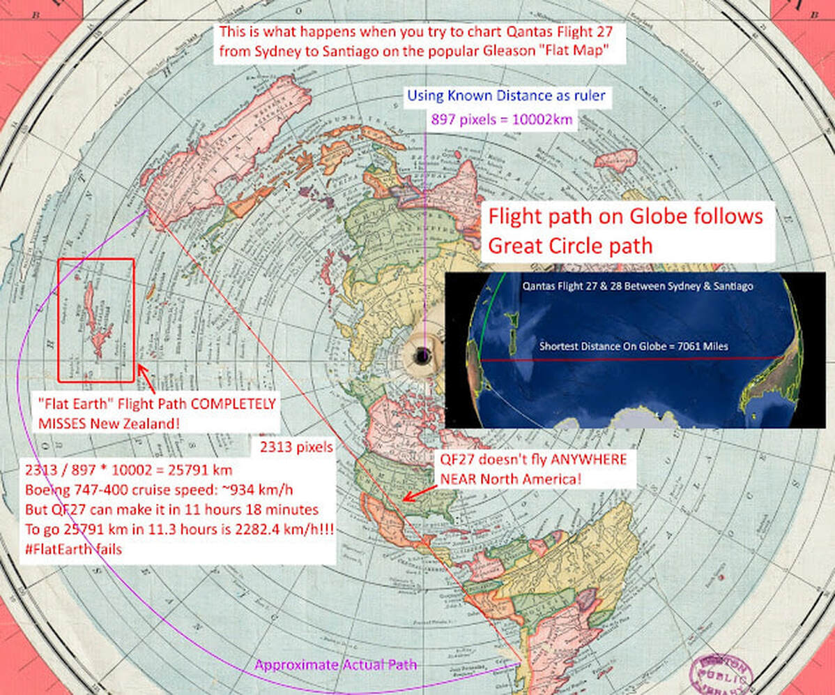
There is no way to make the know flight times from Sydney to Santiago on the Flat Earth map -- it would be insanely far and to "fool" everyone it would have to be even long so they could fly the crazy arc flight to avoid the US and all points in between.
How can Australia to South America flights happen in the well known flight times and paths they provably do on a flat earth? Santiago to Sydney Flights are way too quick. Planes would have to be going at well beyond supersonic speeds as this distance on a flat earth is twice as far. These cities are on direct OPPOSITE sides of the flat earth model, so because of this, these flights are just not possible in known trajectories and times on a flat earth.
There is no way to make the know flight times from Sydney to Santiago on the Flat Earth map -- it would be insanely far and to "fool" everyone it would have to be even long so they could fly the crazy arc flight to avoid the US and all points in between.
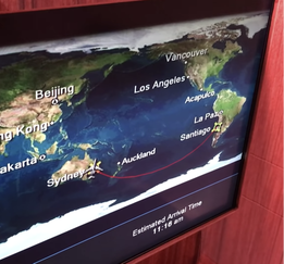
If you claim the flight takes the purple route, then can you explain why it passes over New Zealand, as confirmed both by passengers and by people on the ground photographing it flying overhead? Your purple line goes nowhere near New Zealand, it heads almost northwards out of Sydney and passes closer to Papua New Guinea than NZ!
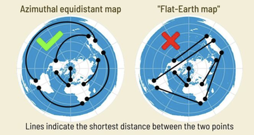
So let's look at the flat earth map, or the thing they pretend isn't their map, but it totally is, because they cannot make a map, so they just use this.
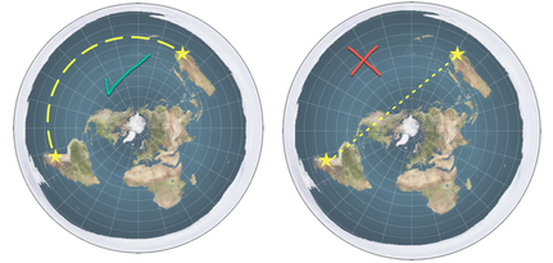
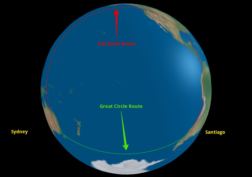
On this flat earth map, Australia and South America are on opposite sides of the flat earth. If the earth was flat, which way would be go? Do flights follow a straight line (see right below with red "x"). Nope they do the whole thing over the Pacific Ocean shown above and also lower left (with green check).
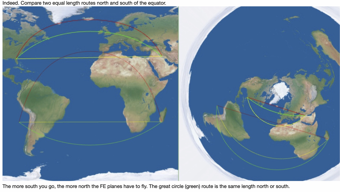
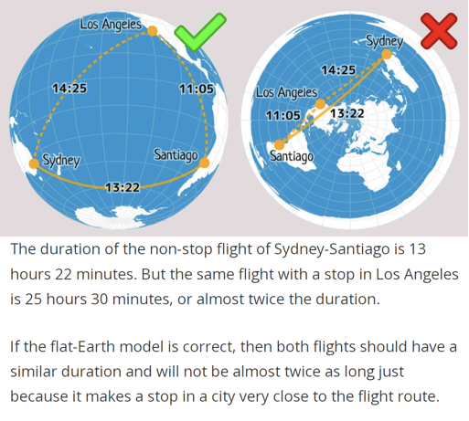
Here above is how this looks on a globe. It takes 14 hours and 15 minutes going west, and 12 hours and 25 minutes going east.
On the flat earth that route would be an absurdly long arc shown below left (with green check - look at the arc between Australia and South America).
The fact that these flights on a flat earth are arcs to begin with is totally nonsensical. Planes flight straight, as we would feel a constant turn. Planes are not constantly turning as they would have to on every flight path we have!!
So how does flat earth explain this nail in the coffin impossibility?
Flat earth's used to deny these flights, but since anyone can google their very easily proven existence, paths and time, they have had to cough up an explanation.
But as you can see, there is no way around this. These flights EXIST! They are NOT traveling this insane distance because the EARTH IS NOT FLAT, IT'S A SPHERE!!
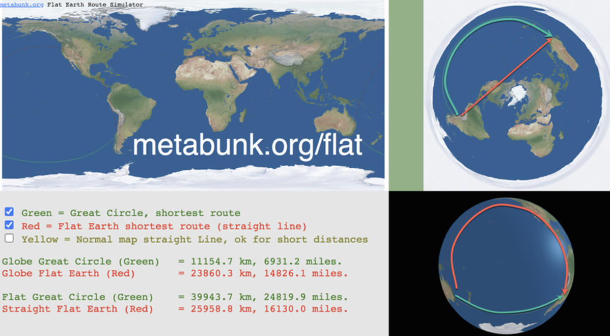
Great circle = shortest distance between two points on a sphere and this is the PATH FLIGHTS TAKE!
On this flat earth map, Australia and South America are on opposite sides of the flat earth. If the earth was flat, which way would be go? Do flights follow a straight line (see right below with red "x"). Nope they do the whole thing over the Pacific Ocean shown above and also lower left (with green check).
Here above is how this looks on a globe. It takes 14 hours and 15 minutes going west, and 12 hours and 25 minutes going east.
On the flat earth that route would be an absurdly long arc shown below left (with green check - look at the arc between Australia and South America).
The fact that these flights on a flat earth are arcs to begin with is totally nonsensical. Planes flight straight, as we would feel a constant turn. Planes are not constantly turning as they would have to on every flight path we have!!
So how does flat earth explain this nail in the coffin impossibility?
Flat earth's used to deny these flights, but since anyone can google their very easily proven existence, paths and time, they have had to cough up an explanation.
But as you can see, there is no way around this. These flights EXIST! They are NOT traveling this insane distance because the EARTH IS NOT FLAT, IT'S A SPHERE!!
Great circle = shortest distance between two points on a sphere and this is the PATH FLIGHTS TAKE!
|
|
SEE FOR YOURSELF!!
Skyscanner lets you look at flights for a whole month.
Pick any month and Choose
Skyscanner lets you look at flights for a whole month.
Pick any month and Choose


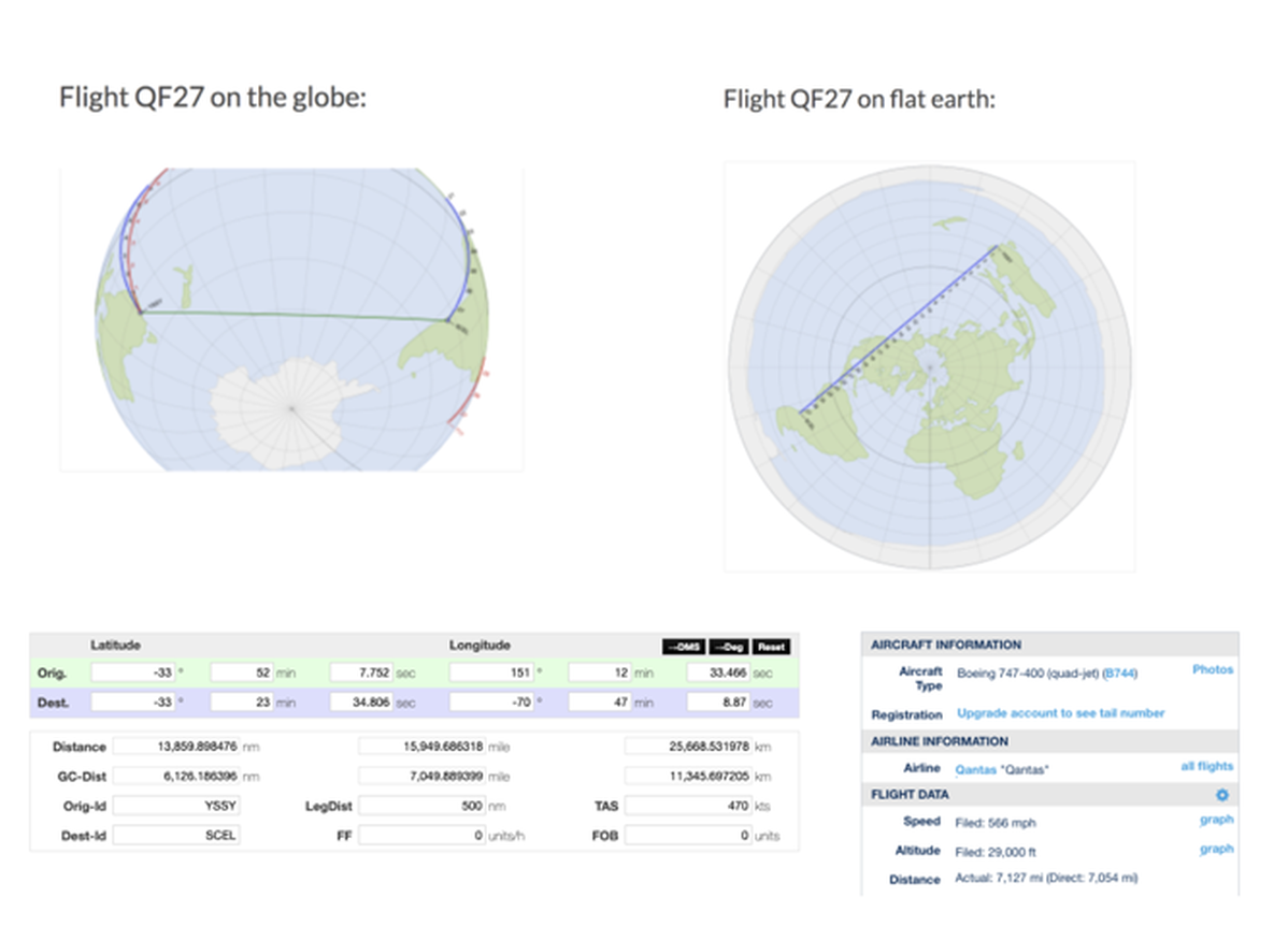
Sydney to Santiago direct (Great Circle Route) - Setting it up in the "GLOBAL" Express in a plane capable of doing Sydney. You can see this from a Plane the actual data.
The reason many airlines route though the Northern Hemisphere is due to Cabotage Laws that prevent them flying the Southern Routes direct.
The reason many airlines route though the Northern Hemisphere is due to Cabotage Laws that prevent them flying the Southern Routes direct.
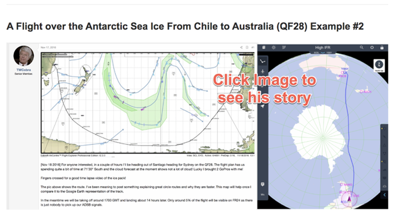
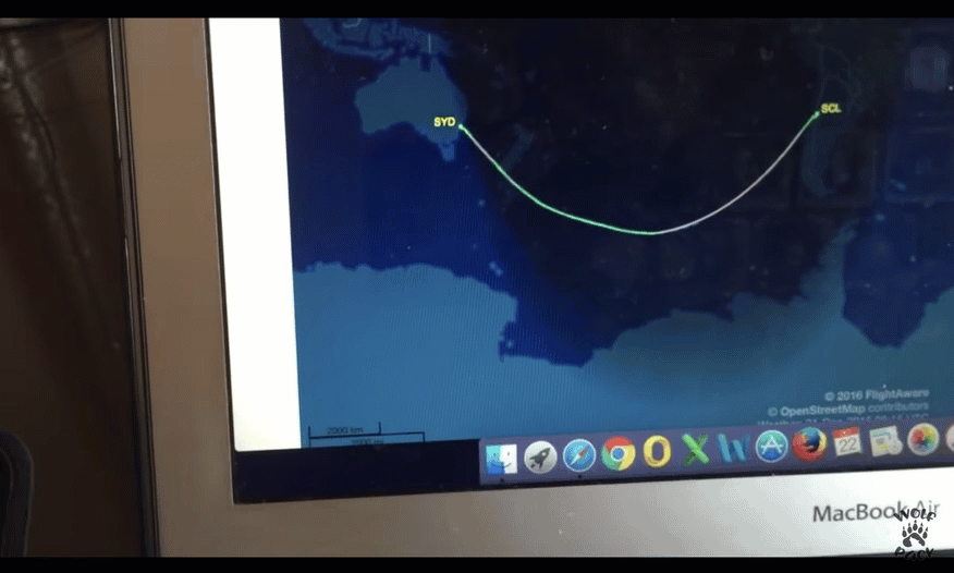
Sydney Airport 22nd January - QF27 boarding non stop to Santiago.
Flightaware.com - full file flight plan
Foreflight - app
You can enter this flight data and see that the flight path follows a great circle which is the shortest distance between two points on a globe.
Flightaware.com - full file flight plan
Foreflight - app
You can enter this flight data and see that the flight path follows a great circle which is the shortest distance between two points on a globe.
Haversine Formula
Former Flat Earther Switches to Globe Because of the Impossible Flight!
THIS IMPOSSIBLE FLIGHT made one former flat earther switch to the Globe AND he deleted ALL his flat earth videos.
See His Video Below!
ANYONE HAS AN OPEN MIND TO INVESTIGATE THIS IMPOSSIBLE FLIGHT, YOU WILL SWITCH TOO! IT IS IMPOSSIBLE ON A FLAT EARTH!
Even a former flat Earth advocate admitted Earth cant be flat due to polar flights from Johannesburg to Sydney travel time of 12 hours-
Long Direct Flights in the Southern Hemisphere Debunk the Flat Earth!
If the earth were flat, all long distance flights would work on a flat map. Long distance flights do not work on a flat map, therefore the earth isn’t flat.
These regular flights in the southern hemisphere are impossible on a flat earth:
QF27/QF28 Sydney – Santiago
QF63/QF64 Sydney – Johannesburg
SA222/SA223 Johannesburg – São Paulo
LA800/LA801 Auckland – Santiago
SA280/SA281 Perth – Johannesburg
ANZ30/ANZ31 Auckland – Buenos Aires
Flat earthers may try to deflect and show non-direct flights which usually involve transferring to another plane. This is just deception. If the earth is flat these flights would follow a different route and be two to three times as long.
But the worst for Flat earthers is the easy to prove ONE WAY flights from Sydney To Santiago.
These known flight times and paths are IMPOSSIBLE on a flat earth.
Book the flight, take your GPS recorder, and disprove it. Until then, the flat earth idea is low-quality fan-fiction.
But even better is the Where's Wally, analyzes this video from live Himiwara-8 satellite feeds and Elecktal L feeds that corroborate the actual weather going along with the flight. Of course flat earthers claim all images from space are fake, but how much longer can they continue this nonsense now that these satellites take whole disk images every 15 minutes in 11K RESOLUTION (DICOVR every hour)? You cannot just cry fake when when there are literally hundreds of images coming in which such precise detail you can use them to confirm your local weather!!
There are 2 independent systems on board of airliners that give the distance and ground speed: Inertial Navigation Systems (INS) and GPS. Both are completely different systems but give exactly the same values, so either of this systems can be used for navigation. The primary system nowadays is GPS, backed up and cross checked by the INS. From the ground speed and the measured airspeed the wind speed and direction can be calculated, which is presented to the pilots on the navigation display. The INS works by measuring the acceleration and rotation rate of the airplane using accelerometers and gyros. If you integrate the acceleration you get the speed. If you integrate the speed you get the distance. The INS can track the position of the airplane by dead reckoning, starting from a known position (e.g. the start airport). The INS is periodically synchronised with GPS, as long GPS is working.
The INS can calculate the orientation, velocity and position of the airplane without any reference to the outside. To do that, it has to take Gravity, Earth Curvature, Earth Rotation and Coriolis into account. To see some block diagrams of INS which show how earth curvature, gravity and Coriolis is taken into account google: INS take Gravity, Earth Rotation and Coriolis into account bislins Calculating the distance between 2 GPS locations is straight forward using the Haversine formula, because the earth is a globe.
Or if you have thousands of points recorded along the flight you can use vector algebra to calculate the distance between 2 neighbouring points and sum up the distances. I did that with both methods on some recorded flight data and got quite accurate the same total distance. So of course we know exactly the distances between any 2 points on earth, to cm accuracy.
Jet Streams
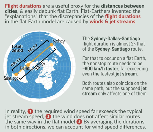
There are forecasts for jet streams, derived from satellite data by the way. So pilots and dispatchers know in advance what jet streams are to be expected and can plan the best routes and calculate the flight time and the needed fuel in advance. No Jet stream can ever boost an airplane to a ground speed of over 2,200 kt, which is required on a flat earth for a direct flight between Sydney and Johannesburg near Antarctica to match the recorded GPS data I have. Common jet stream speeds are rarely more than 150 kt, typically between 50 and 100 kt. Not nearly close enough to reach the required speed on a flat earth. By the way: Jet streams are the product of two factors: the atmospheric heating by solar radiation that produces the large-scale polar, Ferrel, and Hadley circulation cells, and the action of the Coriolis force acting on those moving masses.
Jet streams are very real, but they're not the panacea that flat earthers make them out to be. They only exist at certain altitudes, and in narrow areas. And they move around, so if a flight needed a jet stream to not run out of fuel, it couldn't be a scheduled passenger flight. And because 200 kts is about their limit, they can't be the excuse that flerfs want to make their model appear to work. Yes, they only go one way, because the earth is a spinning globe. One can see that Witless wants so much to become a real boy. But you don't get there by lying. And memorization is not the same as learning.
The INS can calculate the orientation, velocity and position of the airplane without any reference to the outside. To do that, it has to take Gravity, Earth Curvature, Earth Rotation and Coriolis into account. To see some block diagrams of INS which show how earth curvature, gravity and Coriolis is taken into account google: INS take Gravity, Earth Rotation and Coriolis into account bislins Calculating the distance between 2 GPS locations is straight forward using the Haversine formula, because the earth is a globe.
Or if you have thousands of points recorded along the flight you can use vector algebra to calculate the distance between 2 neighbouring points and sum up the distances. I did that with both methods on some recorded flight data and got quite accurate the same total distance. So of course we know exactly the distances between any 2 points on earth, to cm accuracy.
Jet Streams
There are forecasts for jet streams, derived from satellite data by the way. So pilots and dispatchers know in advance what jet streams are to be expected and can plan the best routes and calculate the flight time and the needed fuel in advance. No Jet stream can ever boost an airplane to a ground speed of over 2,200 kt, which is required on a flat earth for a direct flight between Sydney and Johannesburg near Antarctica to match the recorded GPS data I have. Common jet stream speeds are rarely more than 150 kt, typically between 50 and 100 kt. Not nearly close enough to reach the required speed on a flat earth. By the way: Jet streams are the product of two factors: the atmospheric heating by solar radiation that produces the large-scale polar, Ferrel, and Hadley circulation cells, and the action of the Coriolis force acting on those moving masses.
Jet streams are very real, but they're not the panacea that flat earthers make them out to be. They only exist at certain altitudes, and in narrow areas. And they move around, so if a flight needed a jet stream to not run out of fuel, it couldn't be a scheduled passenger flight. And because 200 kts is about their limit, they can't be the excuse that flerfs want to make their model appear to work. Yes, they only go one way, because the earth is a spinning globe. One can see that Witless wants so much to become a real boy. But you don't get there by lying. And memorization is not the same as learning.