Flat Earth Myths Debunked
Buzz Aldrin's Interview
Mythical Dome
Ice Wall
Bokeh
NASA CGI and Composite Photos
The Philosophy of CGI
Tesla Not Flat Earther
Satires - Lead developer google, fake moon landing, donald trump.
Ball and Water Experiment
Eight Inches per mile squared
Flat-Earth “Perspective” is not Real-World Perspective
High Altitude Balloons Deception
NASA and Other Space Agencies
Proofs of Spherical Earth Presented by Flat-Earthers
Ships Disappearing Over the Horizon and the Various “Explanations” Invented by Flat-Earthers
The so-called “Experiment” Done by Flat-Earthers
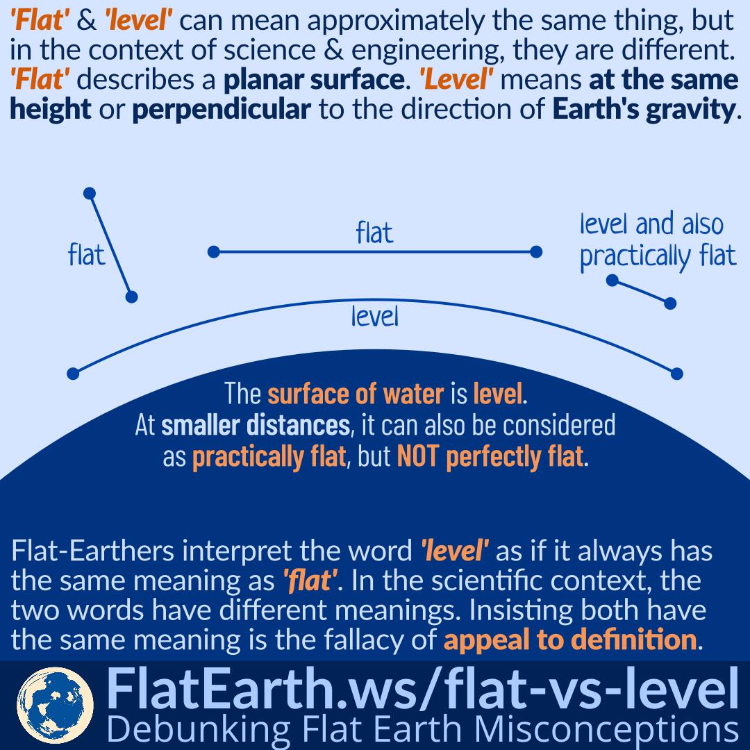
Common Sense: Not a Reliable Indication of Truth
Curvature Calculators and Atmospheric Refraction
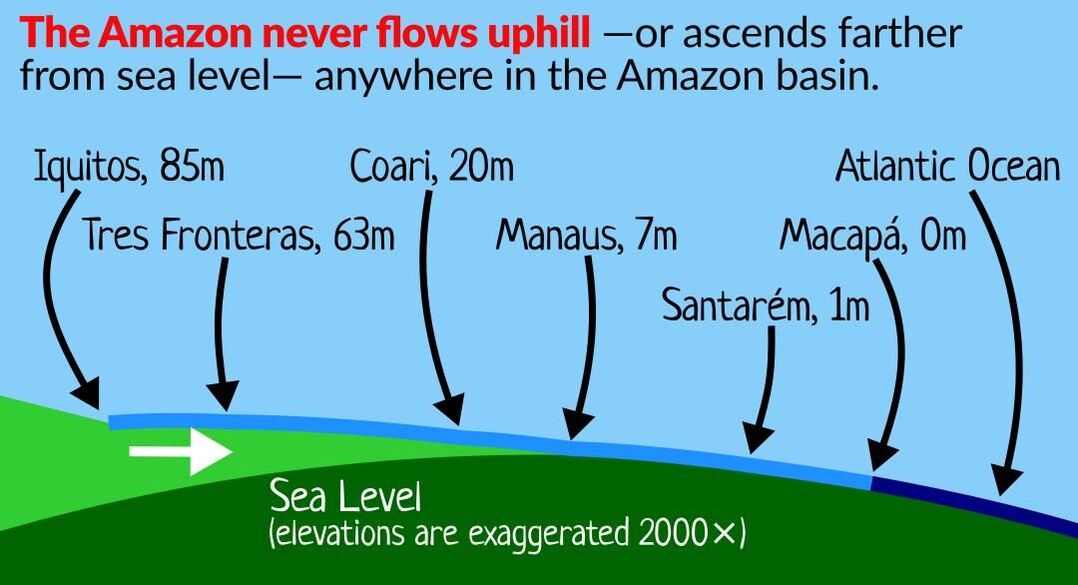
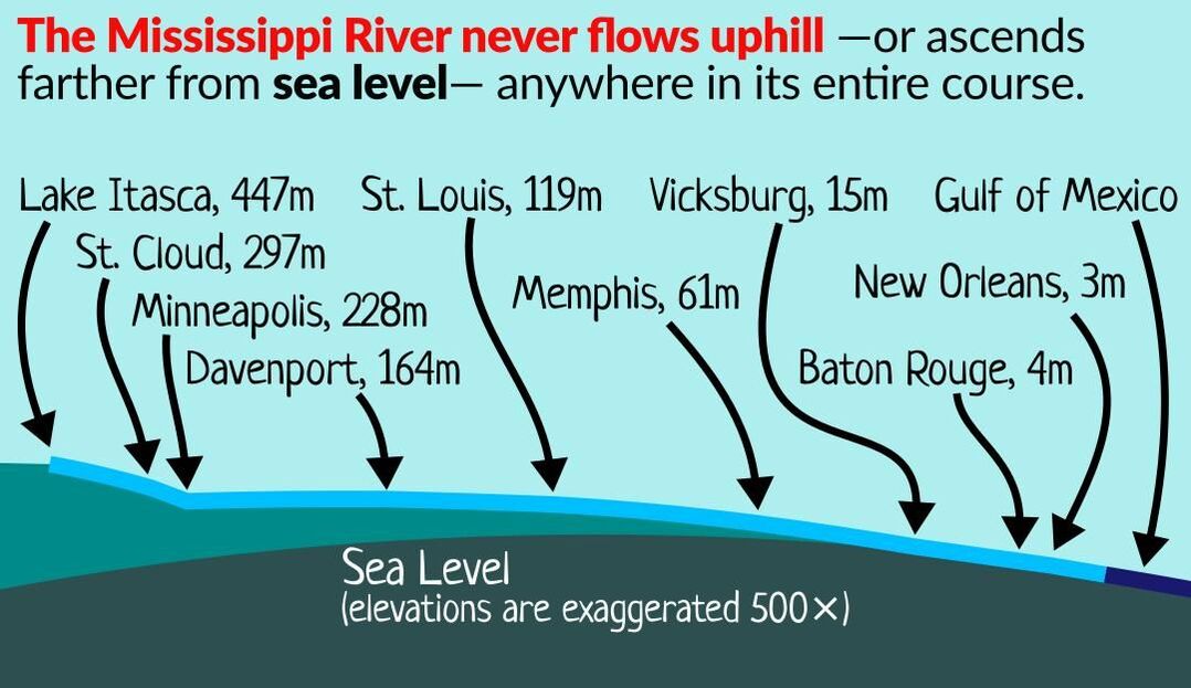
The Earth is Spherical and The Mississippi River Never Flows Uphill Anywhere
Zooming in Will Not Reveal More of a Distant Object
Flat-Earthers' laser tests are misleading
Crepuscular Rays
Flat-Earth Ideology and The Fallacy of Lonely Fact
Nikon Coolpix P900 and The Supposedly ‘Real’ Pictures of Venus
Consistency of Photos of the Earth
Fisheye Lenses and Earth Curvature
Sunglint
Moonlight and the Cooling Effect Myth
Radiative Cooling and Moonlight cooler
Pressure - 14 pounds per square inch... next to zero in space ...101, 000 PA. Atmosphere heated by sun and gravity. (like sun).
Buzz Aldrin's Interview
Mythical Dome
Ice Wall
Bokeh
NASA CGI and Composite Photos
The Philosophy of CGI
Tesla Not Flat Earther
Satires - Lead developer google, fake moon landing, donald trump.
Ball and Water Experiment
Eight Inches per mile squared
Flat-Earth “Perspective” is not Real-World Perspective
High Altitude Balloons Deception
NASA and Other Space Agencies
Proofs of Spherical Earth Presented by Flat-Earthers
Ships Disappearing Over the Horizon and the Various “Explanations” Invented by Flat-Earthers
The so-called “Experiment” Done by Flat-Earthers
Common Sense: Not a Reliable Indication of Truth
Curvature Calculators and Atmospheric Refraction
The Earth is Spherical and The Mississippi River Never Flows Uphill Anywhere
Zooming in Will Not Reveal More of a Distant Object
Flat-Earthers' laser tests are misleading
Crepuscular Rays
Flat-Earth Ideology and The Fallacy of Lonely Fact
Nikon Coolpix P900 and The Supposedly ‘Real’ Pictures of Venus
Consistency of Photos of the Earth
Fisheye Lenses and Earth Curvature
Sunglint
Moonlight and the Cooling Effect Myth
Radiative Cooling and Moonlight cooler
Pressure - 14 pounds per square inch... next to zero in space ...101, 000 PA. Atmosphere heated by sun and gravity. (like sun).
|
|
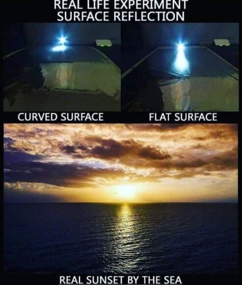
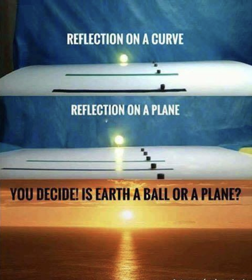
Sun glitter is a bright, sparkling light formed when sunlight reflects from water waves. A rippled by a locally smooth surface such as water with waves will reflect the sun at different angles at each point on the surface of the waves. As a result, a viewer in the right position will see many small images of the sun, formed by portions of waves oriented correctly to reflect the sun’s light to the viewer.
Flat-Earthers use the long shape of the sun’s reflection on a water surface to “prove” Earth is flat. In reality, the shape of the reflection is the result of the rippling water surface. It can easily occur on a curved surface and does not prove a specific shape of Earth.
Flat-Earthers like to devise a “simulation” to show that a curved surface does not form the shape of reflection similar to what we observe during sunset and incorrectly concluded Earth is not a sphere.
Their mistake was placing the observer too far from the surface, making far too large of a curvature to represent spherical Earth, and using an even, smooth surface.
The reflection of rippling water can be easily simulated using a sheet of wrinkled aluminum foil. By placing it over a curved surface, we can see it producing the same result.
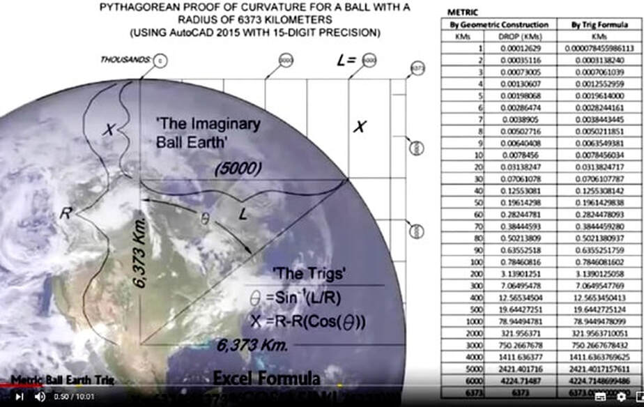
"8 Inches Per Mile Squared" is a rule of thumb to determine the drop height due to the curvature of the earth. It does NOT account for the observer's height and refraction, and thus is unsuitable to determine the visibility of a distant object. And even if the height was sea level, it is still an approximation (taylor series).
Flat Earthers often use the "8 inches" rule to reach the conclusion.... that I see this thing a distance away , but I shouldn't therefore the earth is flat.
....similar to "X is visible, but at a distance of Y miles, X should be Z feet below the horizon.
Flat Earthers often use the "8 inches" rule to reach the conclusion.... that I see this thing a distance away , but I shouldn't therefore the earth is flat.
....similar to "X is visible, but at a distance of Y miles, X should be Z feet below the horizon.
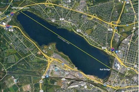
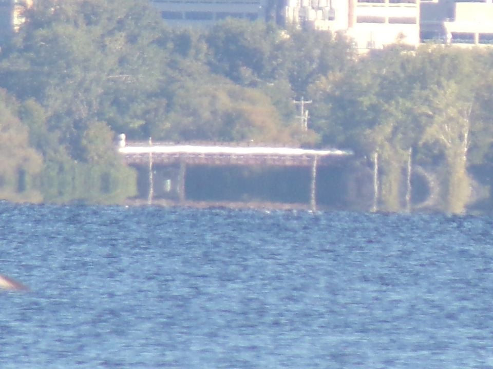
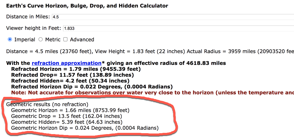
CASE STUDY IN FLAT EARTH
This is the south end of Onandaga lake in Syracuse NY. The photo is a railroad bridge taken from the opposite end of the lake at 4.5 miles. The camera is 22 inches from the water level.The horizon should be at 1.6 miles. The drop should be 13 ft. Clearly the entire water level runs beneath the bridge. You can even see the concrete sidewalk. I measured the bridge to be 14 feet from the water. The water level SHOULD be right to the bottom of the bridge. In a worst case scenario refraction is 5 feet. The light under the bridge is the other side of the bridge as there is a gated path along the water that runs about 25 ft. That light is the other side of the bridge.
https://www.metabunk.org/curve/
|
|
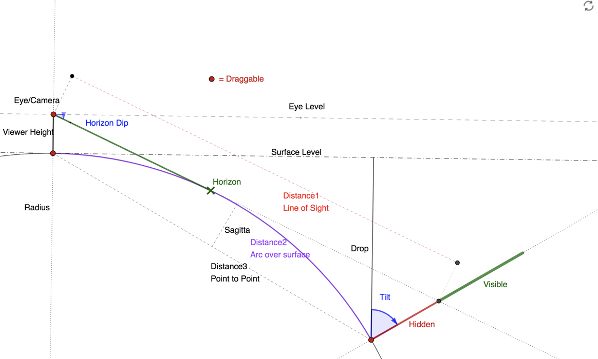
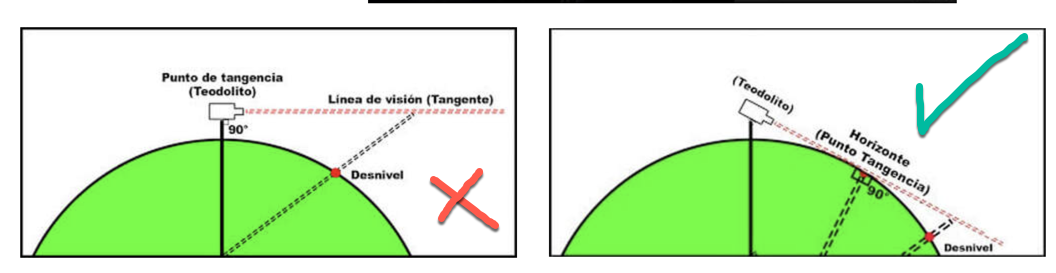
This contains three gross errors:
- It does not consider the height of the observer.
- It does not take into account that in reality, the observer must look towards the horizon (and no ... the horizon is not " at eye level "). This can be represented in this way:
- It does not account for refraction.
|
|
|
|
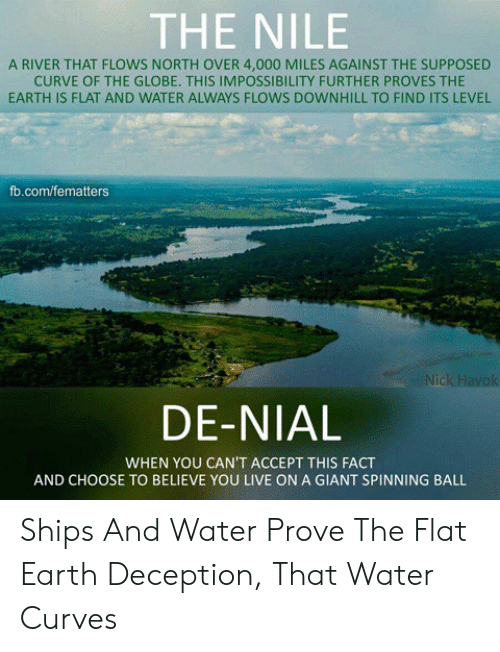
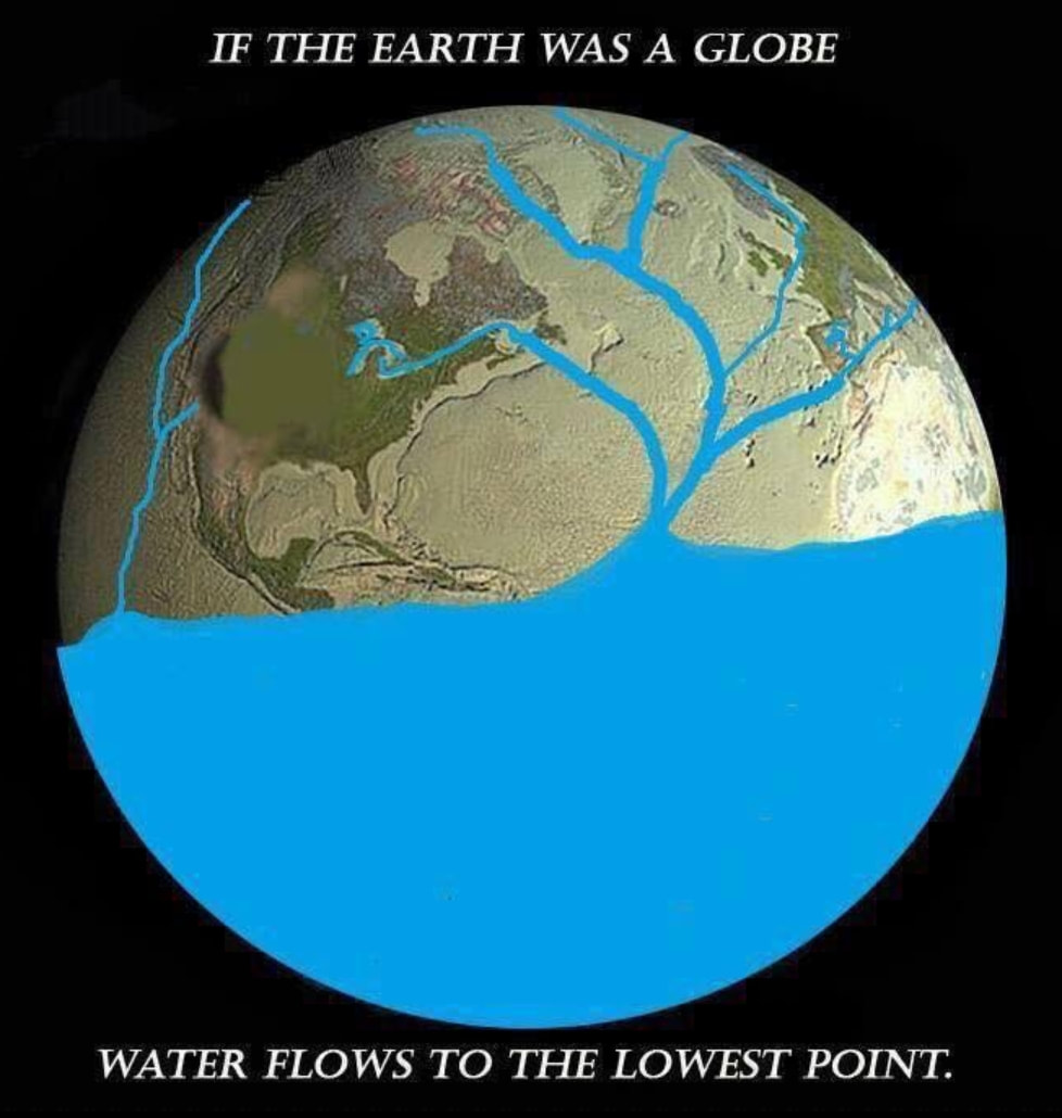
Flat Earthers in De-Nile of Gravity.
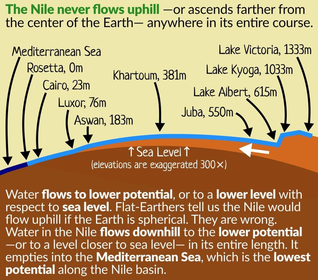
Flat-Earthers often claim that if the Earth is spherical, then the Nile will have to flow uphill to overcome the curvature of the Earth. They are wrong.
Water flows to a lower potential, or in other words to a lower level with respect to sea level. The Nile flows downhill to a level closer to sea level in its entire course. It empties to the Atlantic Ocean, which is the lowest potential along the Nile basin.
The potential on the ‘top’ of the bulge is not necessarily higher than other locations on the river. The only thing that determines the potential is the elevation from sea level.
By Potential, We Mean Gravitational Potential Energy
For the most part, gravity is an equal force pulling down on all parts of the Earth at the same time. It doesn’t matter if it’s Mount Everest or the deepest depths of the Pacific. The principle difference between the two locations is their distance from the center of the earth.
Since all surface areas are measured by their distance from the center of the Earth – not just from the surface up – then water will flow from a point that is farther from the center of the Earth to a point that is closer. This distance can vary by as much as a a couple miles to as little as an inch. Up means altitude NOT latitude!
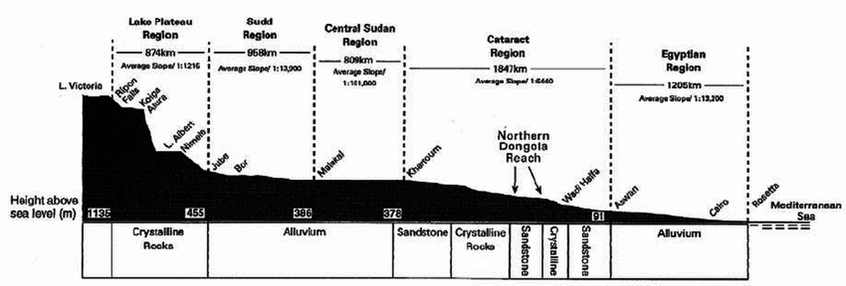
The reason the Nile flows the direction is does because the beginning of the river is farther from the earths center than the end (higher altitude as shown below image), and as such it has more energy (more gravitational potential energy). For the same reason a ball rolls down a hill, water flows from a higher elevation to a lower one.
Think of mountain creeks cascading into a lower pond, which then drains into a stream that might become a tributary flowing into a lake that spills its contents into a river that eventually reaches the ocean. Each step of the way is lower in elevation than the previous one, but also closer to the center of the Earth.
The altitude profile of the Nile says it all. As Does the Amazon and Mississippi
Gravitational potential energy is the same reason water FLOWS to your house from a water tower. The HIGHER ALTITUDE of the water in the tower has a greater gravitational potential energy than your house, hence it flows downward (in ALTITUDE). This is also how water power works in dams: Gravitational Potential Energy!
So, Just because there’s the curvature of the Earth doesn’t mean the water has to ‘climb’.
Flat-Earthers often claim that if the Earth is spherical, then the Nile will have to flow uphill to overcome the curvature of the Earth. They are wrong.
Water flows to a lower potential, or in other words to a lower level with respect to sea level. The Nile flows downhill to a level closer to sea level in its entire course. It empties to the Atlantic Ocean, which is the lowest potential along the Nile basin.
The potential on the ‘top’ of the bulge is not necessarily higher than other locations on the river. The only thing that determines the potential is the elevation from sea level.
By Potential, We Mean Gravitational Potential Energy
For the most part, gravity is an equal force pulling down on all parts of the Earth at the same time. It doesn’t matter if it’s Mount Everest or the deepest depths of the Pacific. The principle difference between the two locations is their distance from the center of the earth.
Since all surface areas are measured by their distance from the center of the Earth – not just from the surface up – then water will flow from a point that is farther from the center of the Earth to a point that is closer. This distance can vary by as much as a a couple miles to as little as an inch. Up means altitude NOT latitude!
The reason the Nile flows the direction is does because the beginning of the river is farther from the earths center than the end (higher altitude as shown below image), and as such it has more energy (more gravitational potential energy). For the same reason a ball rolls down a hill, water flows from a higher elevation to a lower one.
Think of mountain creeks cascading into a lower pond, which then drains into a stream that might become a tributary flowing into a lake that spills its contents into a river that eventually reaches the ocean. Each step of the way is lower in elevation than the previous one, but also closer to the center of the Earth.
The altitude profile of the Nile says it all. As Does the Amazon and Mississippi
Gravitational potential energy is the same reason water FLOWS to your house from a water tower. The HIGHER ALTITUDE of the water in the tower has a greater gravitational potential energy than your house, hence it flows downward (in ALTITUDE). This is also how water power works in dams: Gravitational Potential Energy!
So, Just because there’s the curvature of the Earth doesn’t mean the water has to ‘climb’.
|
|
|
|