Himawari 8, Killing Flat Earth Every 10 Minutes!
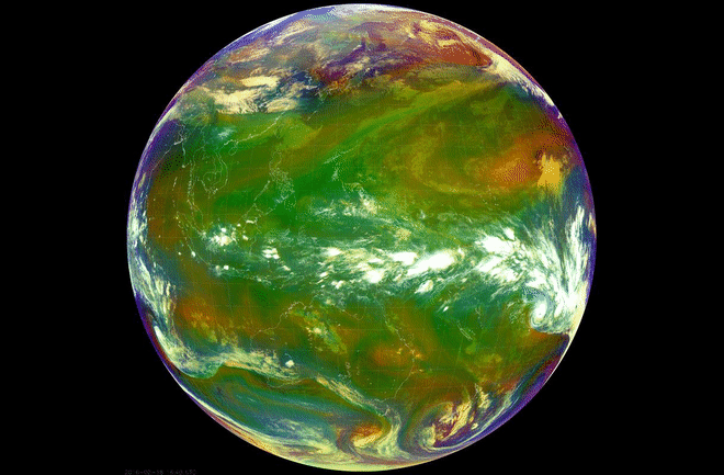
Full image of globe every 10 minutes
Himawari --8/9 - Sunflower
11,000 x 11,000 state of the art in weather observation -Oblateness of globe
Advanced Himawari Imager (AHI) is a Multispectral Camera with sixteen channels (0.46 µm to 13.3 µm)
1/2 kilometer to 2 kilometers.
in the range of visible light and in the infrared range and provides overview and detail shots.
The camera provides cloud, temperature, wind, precipitation, and aerosol distribution data over the various spectral ranges.
A photo or video camera has sensors that are sensitive in the visible spectrum of the light.
The spectrum is recorded with 3 overlapping independent channels which delivers gray scale image data
for each of the color channels: red, green and blue. If these channels are superimposed, a so-called true color image is recreated.
Because while we can appreciate this pictures for their beauty these are actually meteorological satellites!
The data that comes down is important for predicting weather and other things.
The data that comes down is important for predicting weather and other things.
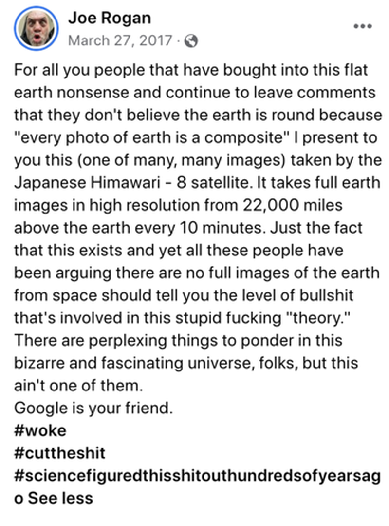
Joe Rogan gets it!
The Himawari 8 is a Flat Earth Killer (as is GOES-16)!
Himawari-8 weather satellite (22,000 miles away) - 11K resolution!
Himawari-8 is a Japanese weather satellite, and so is in orbit over the Equator with a good view of Japan. It is remarkably high resolution, producing images 11,000 pixels square (121 Megapixels), and in color. It can go up to 22,000 pixels (484 megapixels) in B&W (using just the red wavelength of light)
Its considerable distance from Earth isn’t necessarily surprising; most weather satellites do their work in high earth orbit. But what makes Himawari-8 unique among its colleagues is the fact that it is capable of taking full-color photos of the entire planet. Every day, it sends 144 of these “living portraits” back down to Earth – or one photograph every ten minutes.
REAL TIME PHOTOS OF EASTERN HEMISPHERE. With an unprecedentedly high resolution that can visualize features as small as 500 square meters!
https://himawari8.nict.go.jp/
Jeranism Stitch Lines Debunked
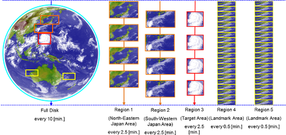
Each 10-minute period incorporates one Full Disk scan, four Japan Area and Target Area scans, and twenty scans for each Landmark Area.
This 10-minute sequence is a basic unit of the observation schedule timeline. In Himawari-8 and -9 baseline observations, the timeline is repeated every 10 minutes except during housekeeping operation.
This 10-minute sequence is a basic unit of the observation schedule timeline. In Himawari-8 and -9 baseline observations, the timeline is repeated every 10 minutes except during housekeeping operation.
|
|
|
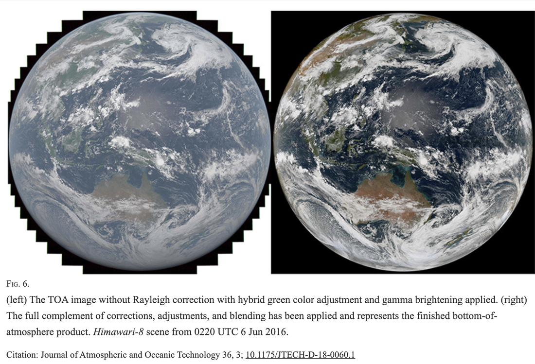
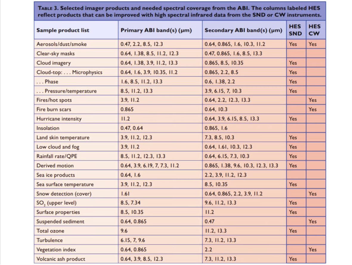
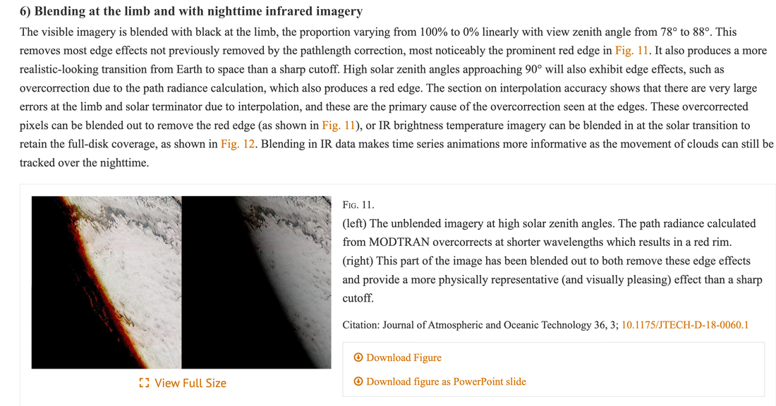
https://journals.ametsoc.org/view/journals/atot/36/3/jtech-d-18-0060.1.xml
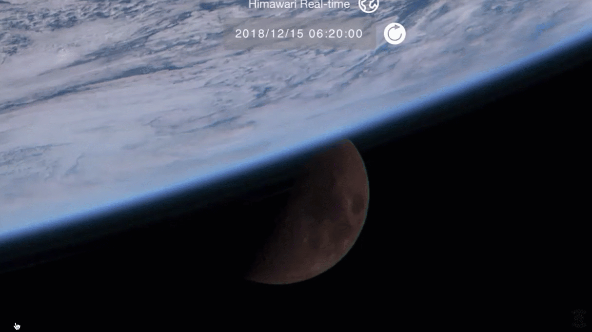
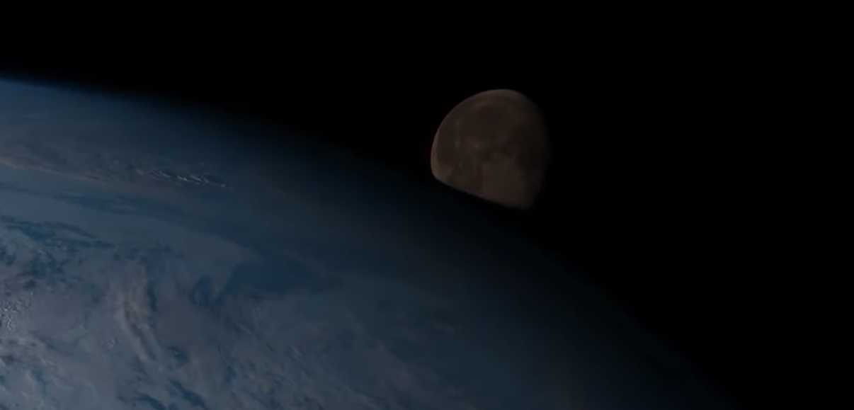
Some Flat Earthers like Jeran Complain the Himawari 8 and others doesn't see the moon. They are WRONG.
The moon is ONLY seen very close to the earth because of the way the Himawari 8 sweeps and scans the earth.
The moon is ONLY seen very close to the earth because of the way the Himawari 8 sweeps and scans the earth.
"Why Would You Accept 10-15 minutes late?" ... Jeranism Embarrassed Again
https://www.data.jma.go.jp/mscweb/en/himawari89/space_segment/spsg_ahi.html
Each 10-minute period incorporates one Full Disk scan, four Japan Area and Target Area scans, and twenty scans for each Landmark Area. This 10-minute sequence is a basic unit of the observation schedule timeline. In Himawari-8 and -9 baseline observations, the timeline is repeated every 10 minutes except during housekeeping operation.
Each 10-minute period incorporates one Full Disk scan, four Japan Area and Target Area scans, and twenty scans for each Landmark Area. This 10-minute sequence is a basic unit of the observation schedule timeline. In Himawari-8 and -9 baseline observations, the timeline is repeated every 10 minutes except during housekeeping operation.
U.S. GOES-16 (15 Minutes)
U.S. satellites are doing the imaging a little different, so it gives the GOES an extra 5 minutes to scan the internal continental U.S. at a higher temporal frequency.
For more detail on cloud motions.
Can also scan 2 storms.
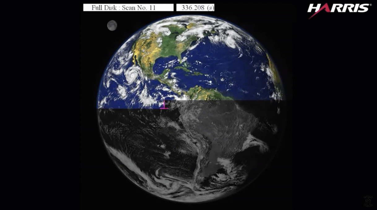
In the daytime you can see the full color globe but at night you can still see the clouds because it is using infrared cameras at night. These are overlaid upon blue marble.
You also see a flicker around midnight where the camera is pointing to the sun
U.S. satellites are doing the imaging a little different, so it gives the GOES an extra 5 minutes to scan the internal continental U.S. at a higher temporal frequency.
For more detail on cloud motions.
Can also scan 2 storms.
In the daytime you can see the full color globe but at night you can still see the clouds because it is using infrared cameras at night. These are overlaid upon blue marble.
You also see a flicker around midnight where the camera is pointing to the sun
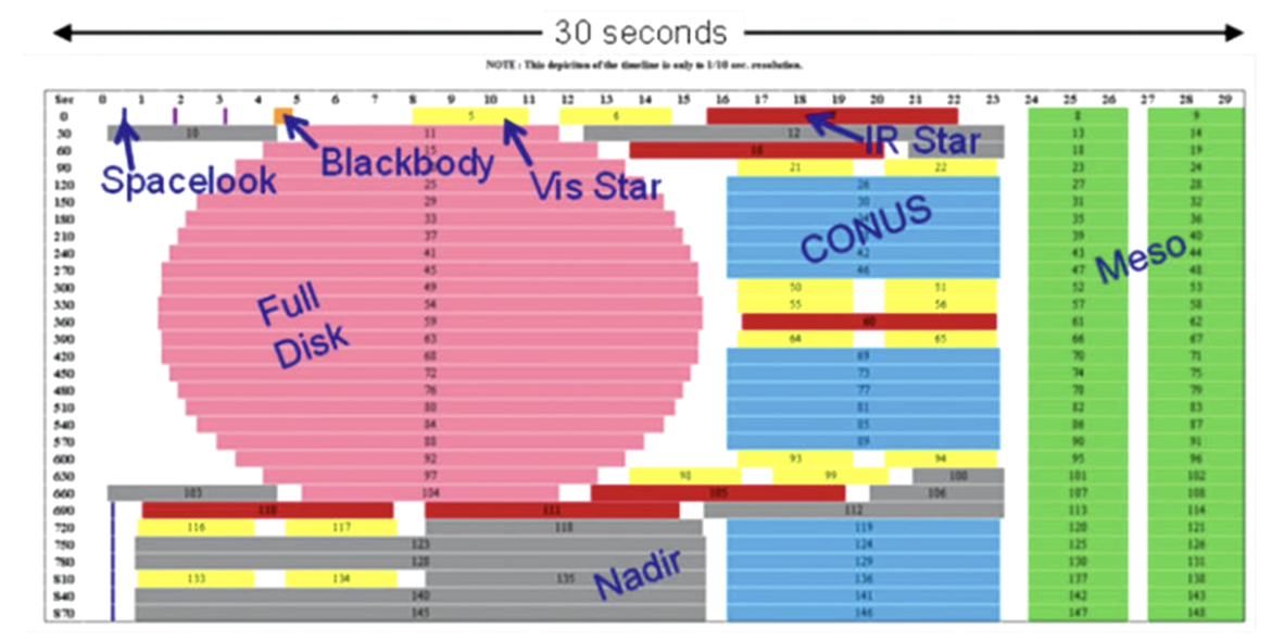
Imaging timetable that shows you all the observations that go on in that 15 minute window
And then repeats it after this,
And then repeats it after this,
DITRH Parroting Paul on the Plane ... DEBUNKED
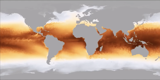
Blue Marble Data Set
https://sos.noaa.gov/catalog/datasets/blue-marble/
Blue marble data set is taken from multiple pole orbiting satellites around the globe. This is a bad point to argue.
Dave is not realizing Himawari is taking 16 different images, one of which is infrared for nighttime.
There is a terminator line in the visible spectrum but not in the IR (so cloud cover can be seen at night)!
Earth Re-radiates 4-30 uM
SHOW HIMAWARI!!!
https://www.data.jma.go.jp/mscweb/en/himawari89/space_segment/hsd_sample/HS_D_users_guide_en_v12.pdf
PAUL: The temperature predictions for the future.
Weather over ocean, software simulations.
For weather over the land, the NOAA has supercomputers that take data coming in from all over the world and combine it with weather simulation over the oceans, they come up with a complete composite weather "map"
Doppler radar does not show clouds, it only shows rain and pressure changes. It does not show cloud cover.
Cloudy day sometimes and no red or green spots on doppler radar in your area.
So what flat earthers are saying is that someone NOAA takes doppler radar which does not actually see cloud cover and mixing it with global prediction for temperature changes and weather simulation, that are not entirely accurate and they also do not measure cloud cover and put it together and we get global cloud cover??
Dave seems to think that annual globe temperature simulations somehow translate
to daily cloud cover simulations through some means which he does not deign to expound upon.
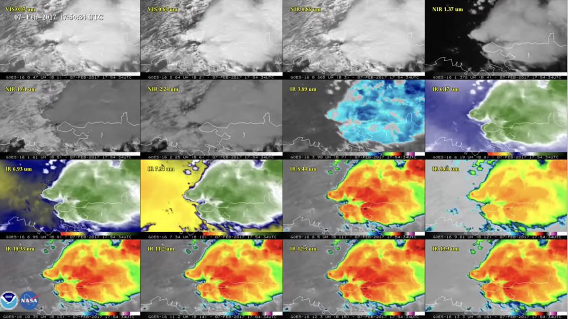
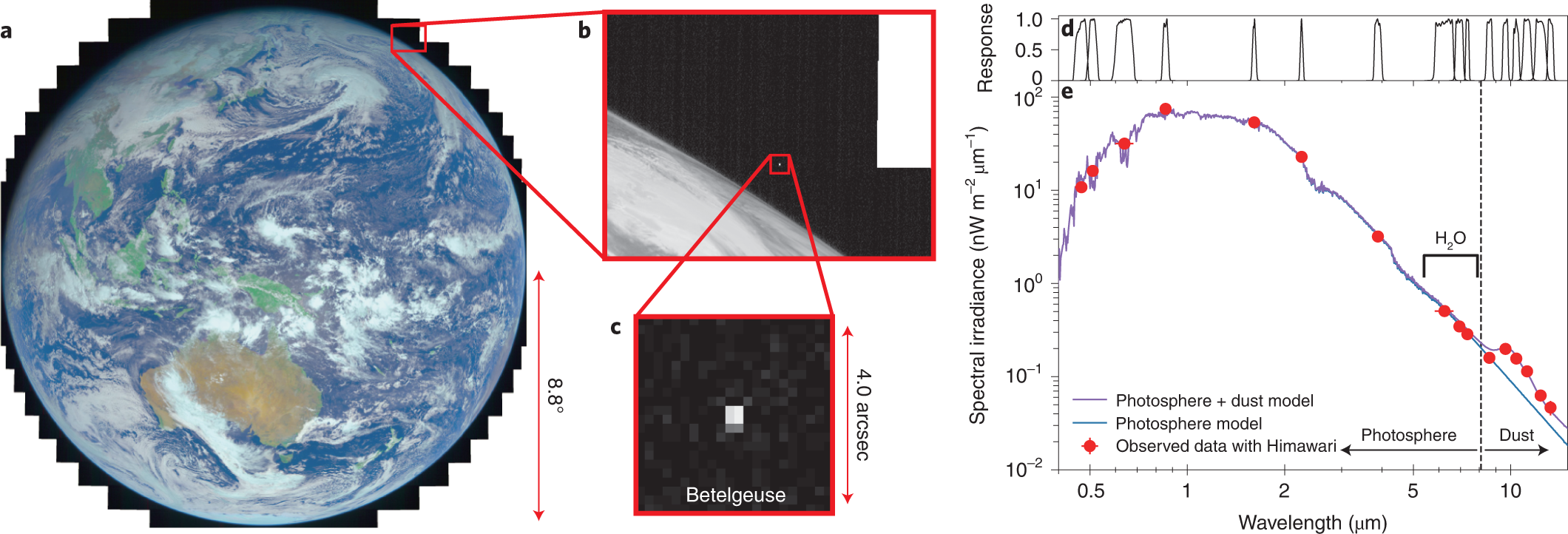
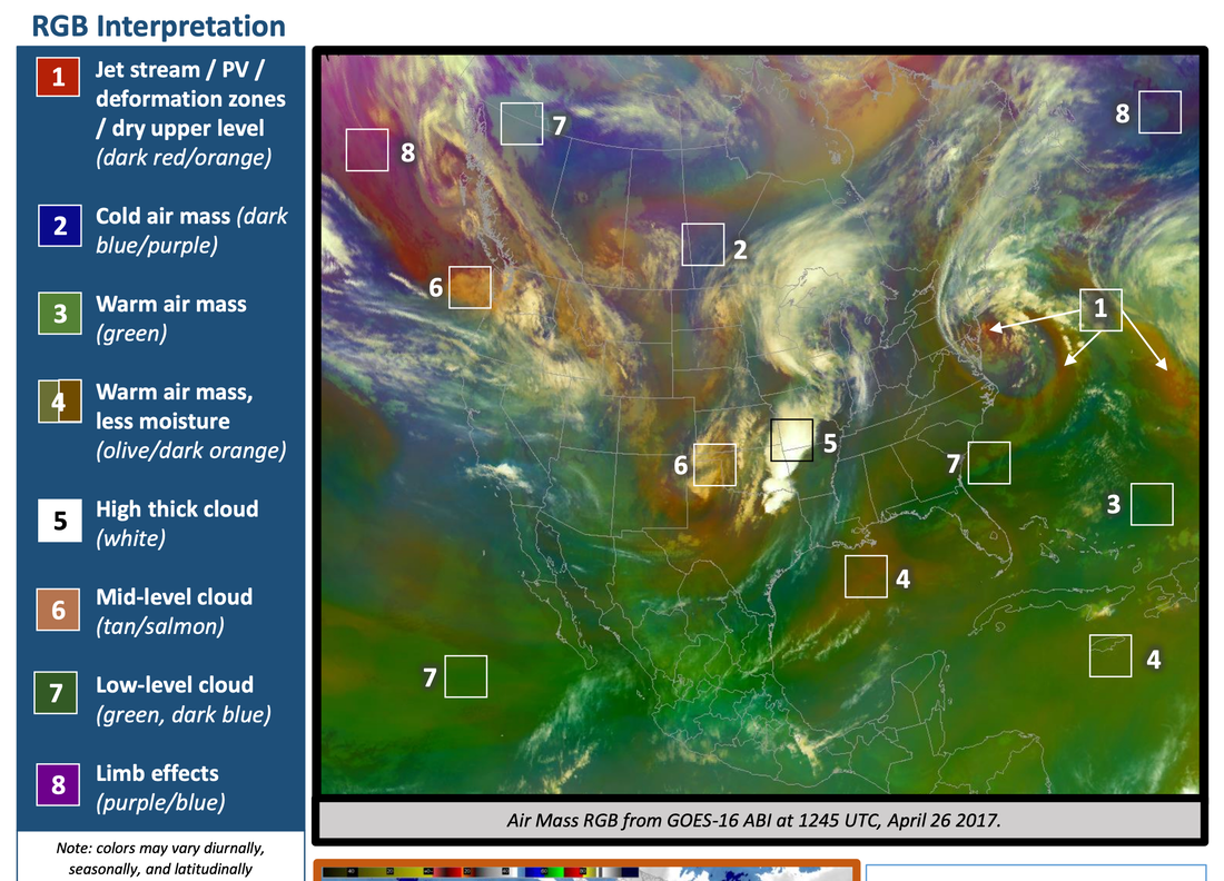
Air Mass imagery via the Himawari-8 satellite,
which shows temperature and moisture characteristics of air masses.
Learn more about how to interpret this type of imagery: bit.ly/3a8KxY3
It is not simply a photo. It is several photos in different wavelengths calibrated to detect different things.
The objective of the Himawari mission is not to prove that the earth is round, but to detect weather phenomena, smoke, &c.
|
|
Doppler Radar .... DITRH DEBUNKED AGAIN!
So, the purpose is to detect the wind speed as well as water vapour in the cloud, not imaging of the cloud.
Impossible to use ground based systems to cover the vast oceans?
Weather over oceans software simulations?? Huh?
For weather over the land...The NOAA has supercomputers taking data coming
in from over the land from Doppler radar feeds and coming it with weather simulation
software over the oceans to come up with a complete composite doppler map.
What about weather balloons? NO, they do not cover the whole earth and there is no
way thousands of weather balloons could all communicate to stitch together a full disk images every 10 minutes. Citations PLEASE!!
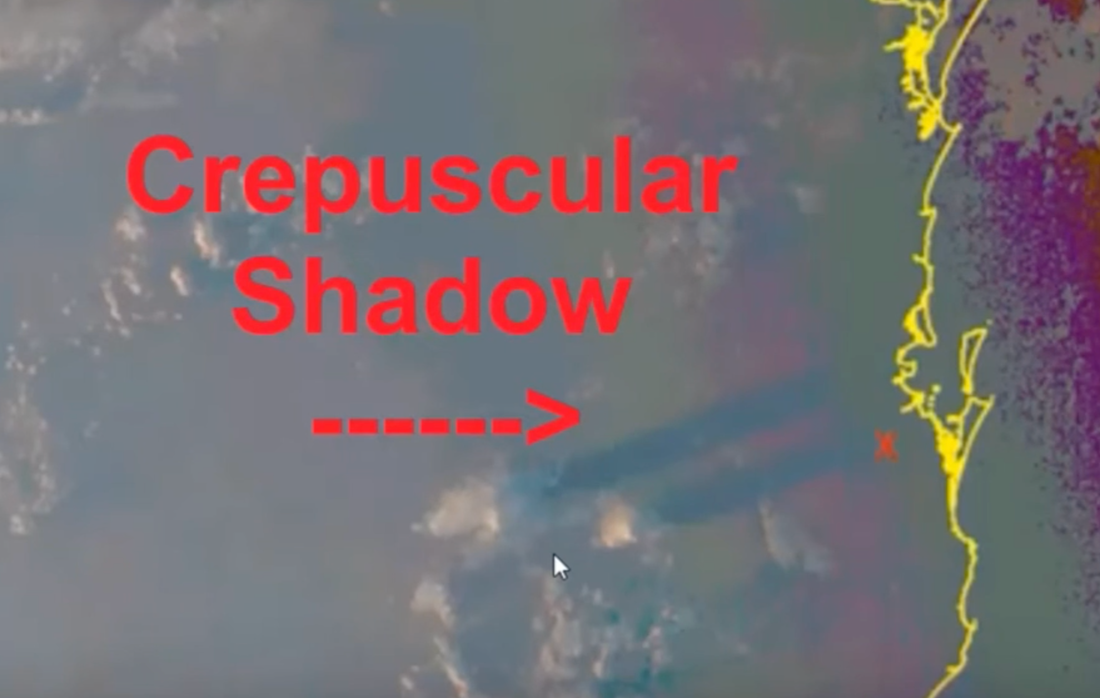
The supposed simulation claim isn't able to account for the things like bush fires and the smoke plumes that are visible both on the Himawari8 and out the window.
The night time clouds are so easy, they use IR images. This is so basic and been done for years.
So the clouds shapes come from the satellite and then go to the computers for modelling and recording for future reference.
On further investigation it seems Himawari satellites use (ABI) to capture and overlay the countries.
Not blue marble data sets.
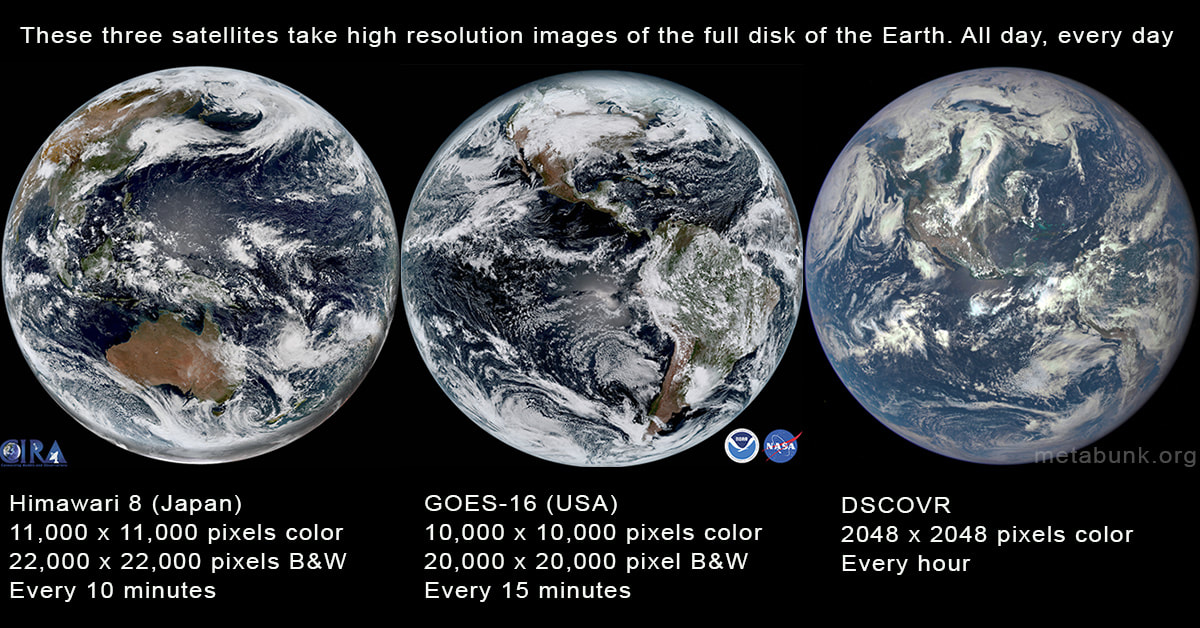
Full Earth Images from Space Taken Daily - HUNDREDS!
There are several satellites that take photos of the full disk of the earth on a regular basis, but the most impressive are the three above. The first two (Himawari-8 and GOES-16) are geostationary satellites taking photos from 22,236 miles above the Earth's equator. The third, DSCOVR is located in an orbit between the Earth and the Sun, about one million miles away. All three take several photos a day
USA: GOES 16 & 17 (RAMMB/CIRA SLIDER) (Zoomable, HD) , NEXLAB, NOAA Full Resolution (17)
Japan: Himawari-8 (JME), RAMDIS Feeds , JME Feed (11K), NICT zoomable archive (best).
USA: DSCOVR (L1) (Full disk rotating Earth from a fixed relative point)
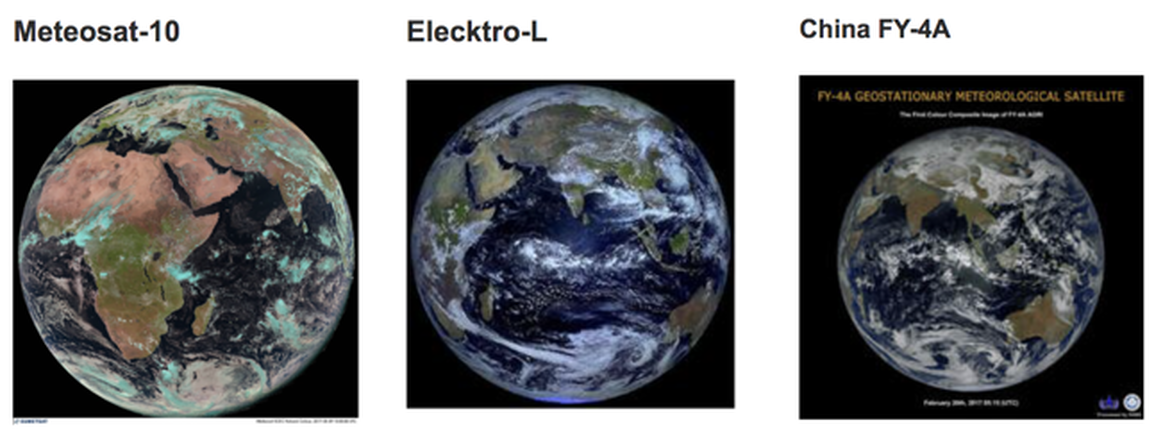
Europe: Meteosat-10 (11K), Historical Viewer (slow)
India: INSAT
Russia: Elektro-L (11K) (Ntsomz interactive view and download) (FTP Archive)
China FY-4A
There are several satellites that take photos of the full disk of the earth on a regular basis, but the most impressive are the three above. The first two (Himawari-8 and GOES-16) are geostationary satellites taking photos from 22,236 miles above the Earth's equator. The third, DSCOVR is located in an orbit between the Earth and the Sun, about one million miles away. All three take several photos a day
USA: GOES 16 & 17 (RAMMB/CIRA SLIDER) (Zoomable, HD) , NEXLAB, NOAA Full Resolution (17)
Japan: Himawari-8 (JME), RAMDIS Feeds , JME Feed (11K), NICT zoomable archive (best).
USA: DSCOVR (L1) (Full disk rotating Earth from a fixed relative point)
Europe: Meteosat-10 (11K), Historical Viewer (slow)
India: INSAT
Russia: Elektro-L (11K) (Ntsomz interactive view and download) (FTP Archive)
China FY-4A
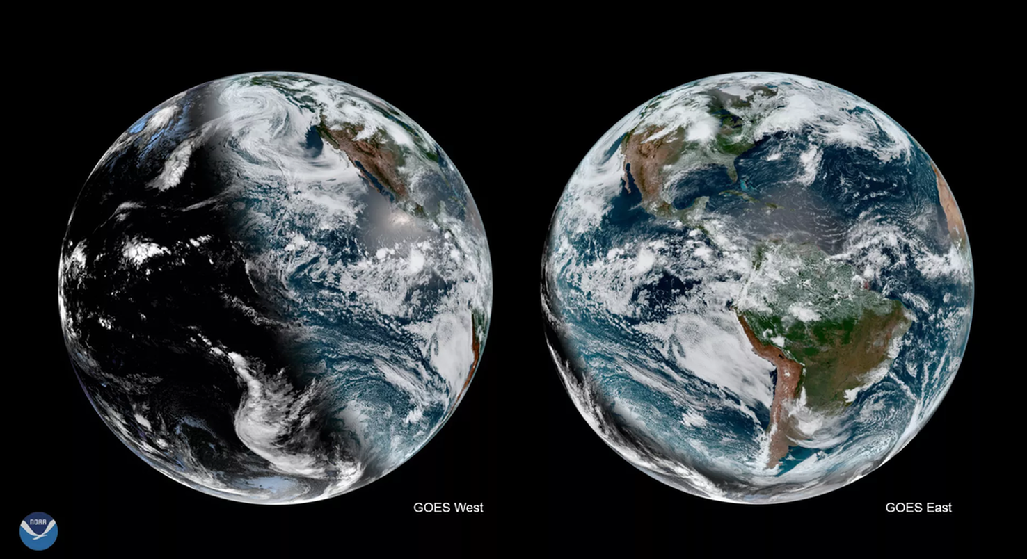
GOES East (GOES-16) and GOES West (GOES-17)
WHOLE EARTH Image of the Earth taken recentlyby GOES-16 satellite
GOES-16 Is basically NASA's version of Himawari-8. Like the Himawari series, the GOES series have all been weather satellites.
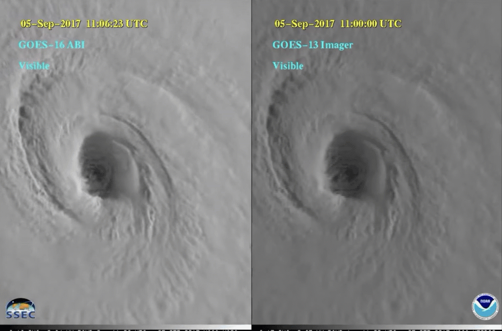
Their primary mission is helping forecast the weather, so up until now they have just given black and white images (one visible wavelength, and several infrared wavelengths). GOES satellites have actually been taking full disk images for many years, but GOES-16 is by far the best, with a higher resolution camera, and color. Here's a comparison of GOES-16 and GOES-13 taken at about the same time. Notice the position is different, GOES-16 being further west than GOES-13
WHOLE EARTH Image of the Earth taken recentlyby GOES-16 satellite
GOES-16 Is basically NASA's version of Himawari-8. Like the Himawari series, the GOES series have all been weather satellites.
Their primary mission is helping forecast the weather, so up until now they have just given black and white images (one visible wavelength, and several infrared wavelengths). GOES satellites have actually been taking full disk images for many years, but GOES-16 is by far the best, with a higher resolution camera, and color. Here's a comparison of GOES-16 and GOES-13 taken at about the same time. Notice the position is different, GOES-16 being further west than GOES-13
Truth Observations
Ground truth observations will be a dagger in the flat earth!
The idea that all this data is faked and yet matches actual weather patterns is just ridiculous.
The idea that all this data is faked and yet matches actual weather patterns is just ridiculous. The idea that somehow ground doppler radar can produce 11K images is Ludicrous. That is NOT how doppler works!!
The idea that all of these are simple photoshop images or even the idea that there are millions of planes and balloons scouring the Earth every minute of the day and night so we get accurate image data we can render into globes is just absurd.
Or I have heard some flat earthers say it is doppler radar at ground level recreating them. CLEARLY THEY DON'T UNDERSTAND DOPPLER RADAR!
Lunar Eclipses
Dust Clouds
Volcanos
Aurora Borealis
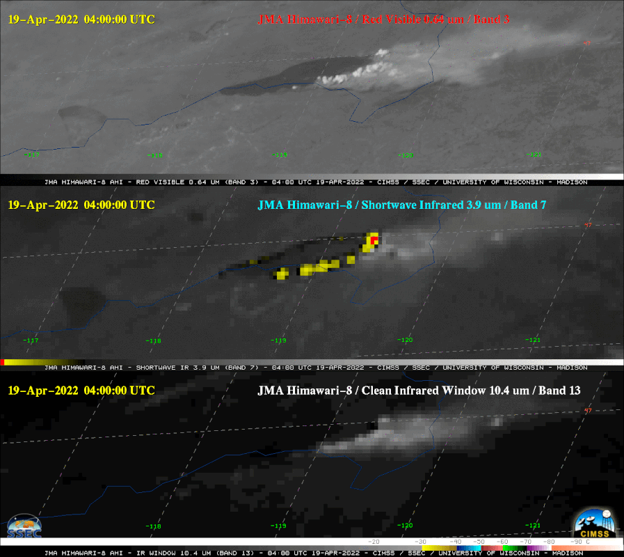
Bush Fires china and australia
Floods / Track Flood Water
Look at some of the brief video clips below of lunar eclipse shadows right on schedule, fires in Australia and China that were caught on Himawari and saved lives (doppler cannot get this), just clouds, volcanos, floods and Aurora Borealis, all things GROUND DOPPLER CANNOT CAPTURE.
The Himawari-8 is a flat earth KILLER (as is GOES 16/17, DISCVR, ELECKTRO-L, METEOSAT and others).
Ground truth observations will be a dagger in the flat earth!
The idea that all this data is faked and yet matches actual weather patterns is just ridiculous.
The idea that all this data is faked and yet matches actual weather patterns is just ridiculous. The idea that somehow ground doppler radar can produce 11K images is Ludicrous. That is NOT how doppler works!!
The idea that all of these are simple photoshop images or even the idea that there are millions of planes and balloons scouring the Earth every minute of the day and night so we get accurate image data we can render into globes is just absurd.
Or I have heard some flat earthers say it is doppler radar at ground level recreating them. CLEARLY THEY DON'T UNDERSTAND DOPPLER RADAR!
Lunar Eclipses
Dust Clouds
Volcanos
Aurora Borealis
Bush Fires china and australia
Floods / Track Flood Water
Look at some of the brief video clips below of lunar eclipse shadows right on schedule, fires in Australia and China that were caught on Himawari and saved lives (doppler cannot get this), just clouds, volcanos, floods and Aurora Borealis, all things GROUND DOPPLER CANNOT CAPTURE.
The Himawari-8 is a flat earth KILLER (as is GOES 16/17, DISCVR, ELECKTRO-L, METEOSAT and others).
Ground Truth Confirmation
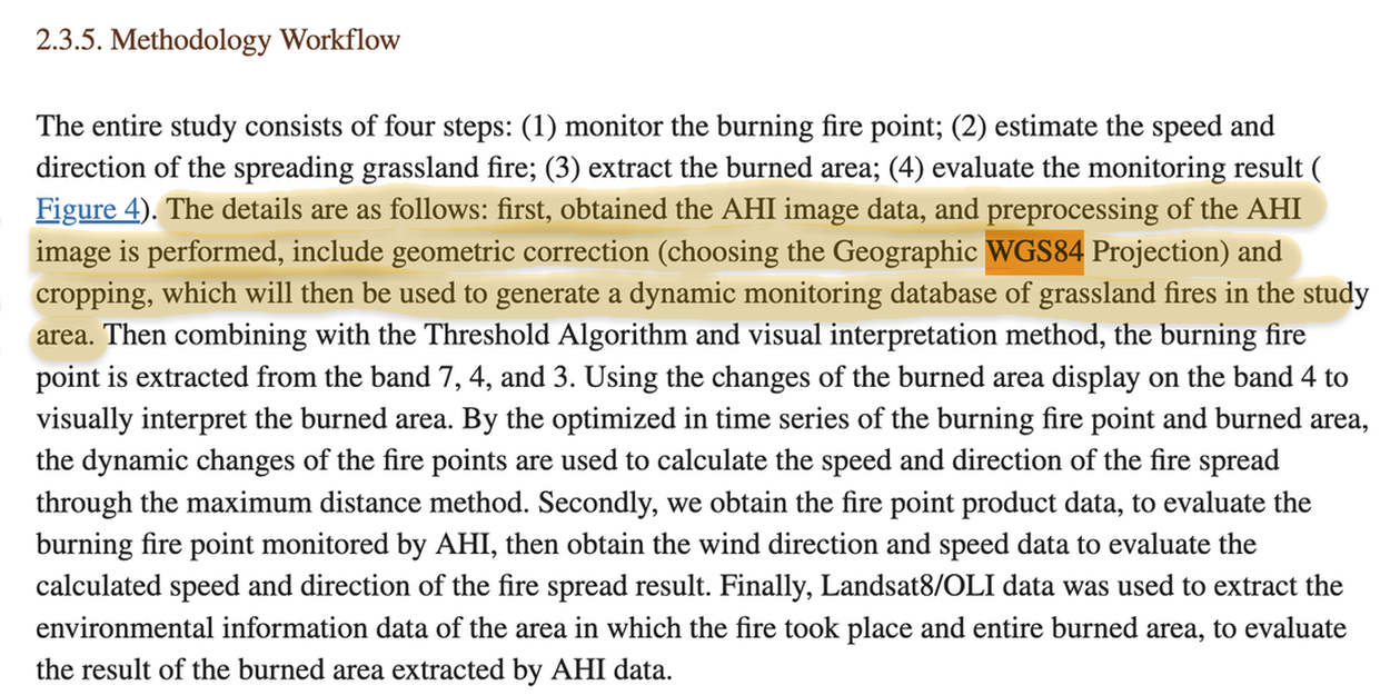
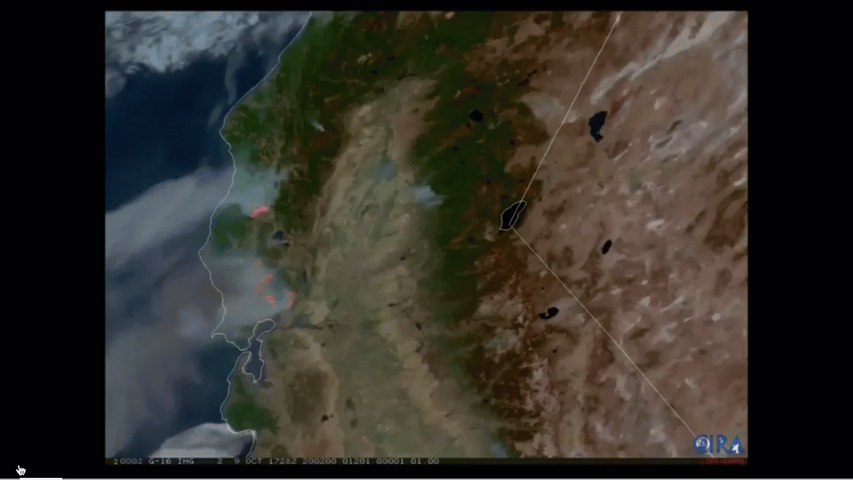
Himawari-8 Satellite Based Dynamic Monitoring of Grassland Fire in China-Mongolia Border Regions
https://www.ncbi.nlm.nih.gov/pmc/articles/PMC5795838/
2015 wildfire on China Mongolia border
From the Himawari 8 they were able to track and predict the
Path of the wildfire and save lives.
Himawari-8 Satellite Based Dynamic Monitoring of Grassland Fire in China-Mongolia Border Regions
https://www.ncbi.nlm.nih.gov/pmc/articles/PMC5795838/
2015 wildfire on China Mongolia border
From the Himawari 8 they were able to track and predict the
Path of the wildfire and save lives.
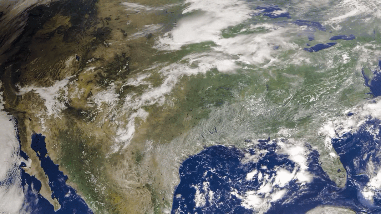
This sequence shows wildfires from Northern California from 2017 from GOES-16
Tracking Hurricanes
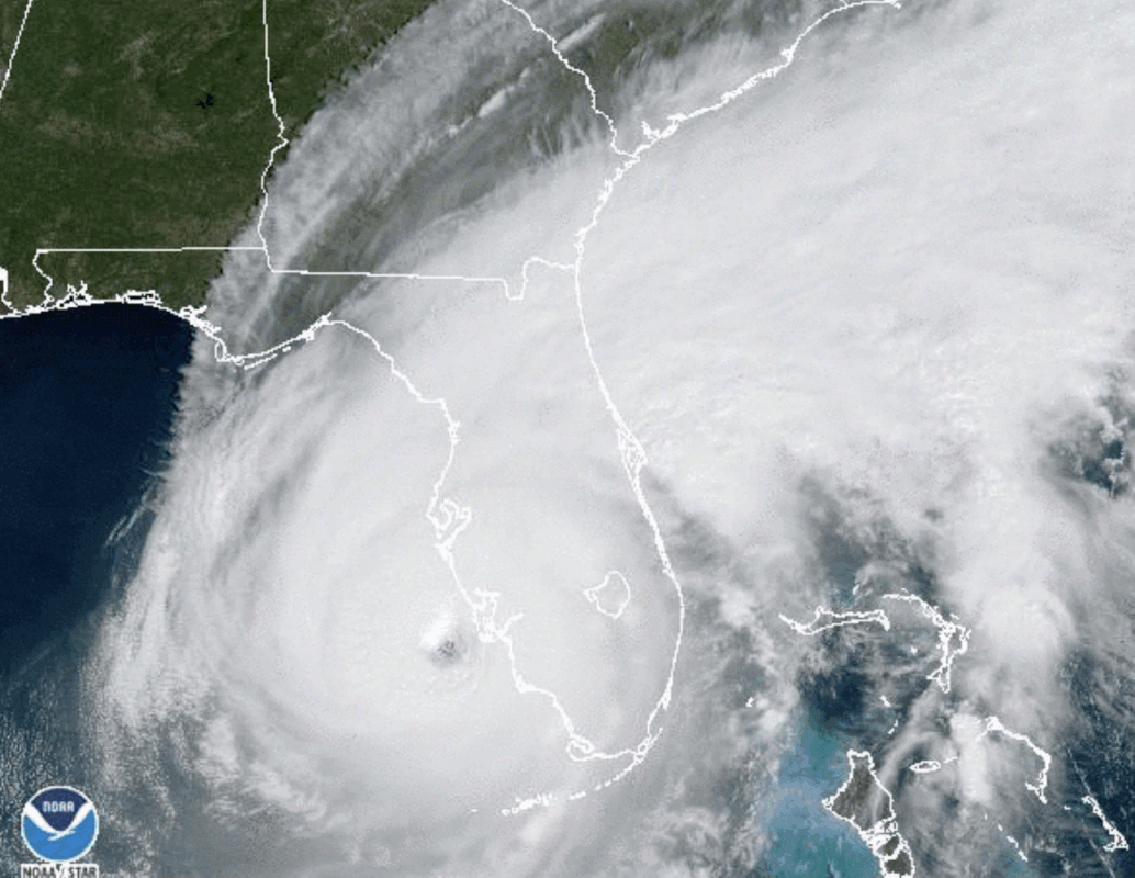
Hurricanes - Living in Florida for 15 years I have been involved with two Major Hurricanes, Hurricane Irma and Hurricane Ian. Being in a flood zone, I fled Florida from Hurricane Irma but I witnessed its devastation when I got back. Very recently I actually endured Hurricane Ian close to my house but in a well protected structure that was not in a flood zone. I watched hurricane Ian from GOES-16 very regularly and was amazing at the size and power of the storm, and amazed also at how high resolution these GOES-16 images were.
Hurricane Irma on Left, Hurricane Ian on Right as it makes landfall and devastates Ft Myers and surrounding area. I was kinda lucky to be JUST BARELY north enough not to get devastating winds, but still A LOT of damage!
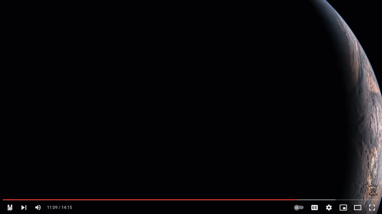
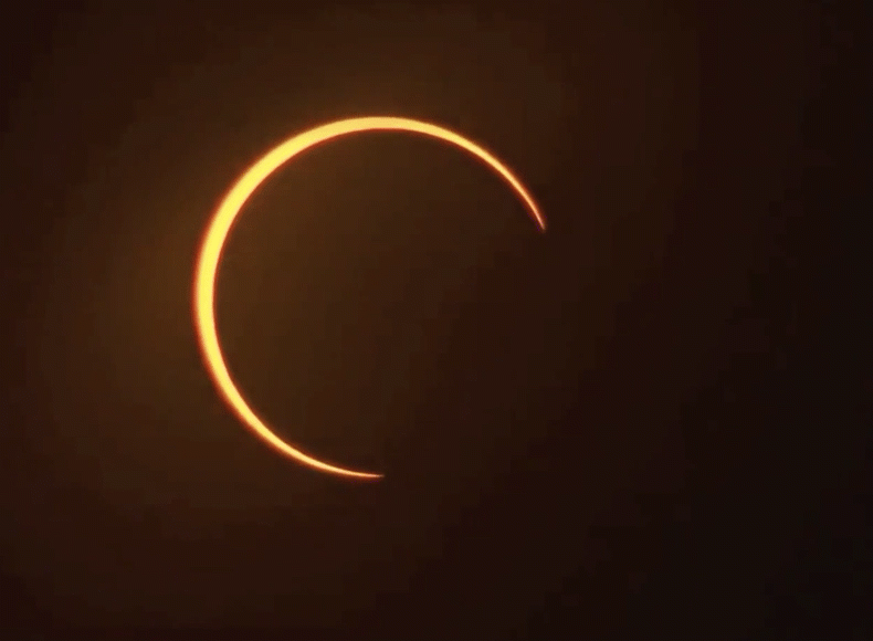
Solar Eclipse from Himawari
University of Wisconsin Madison put together this video of an eclipse passing over the continental U.S. (Below).
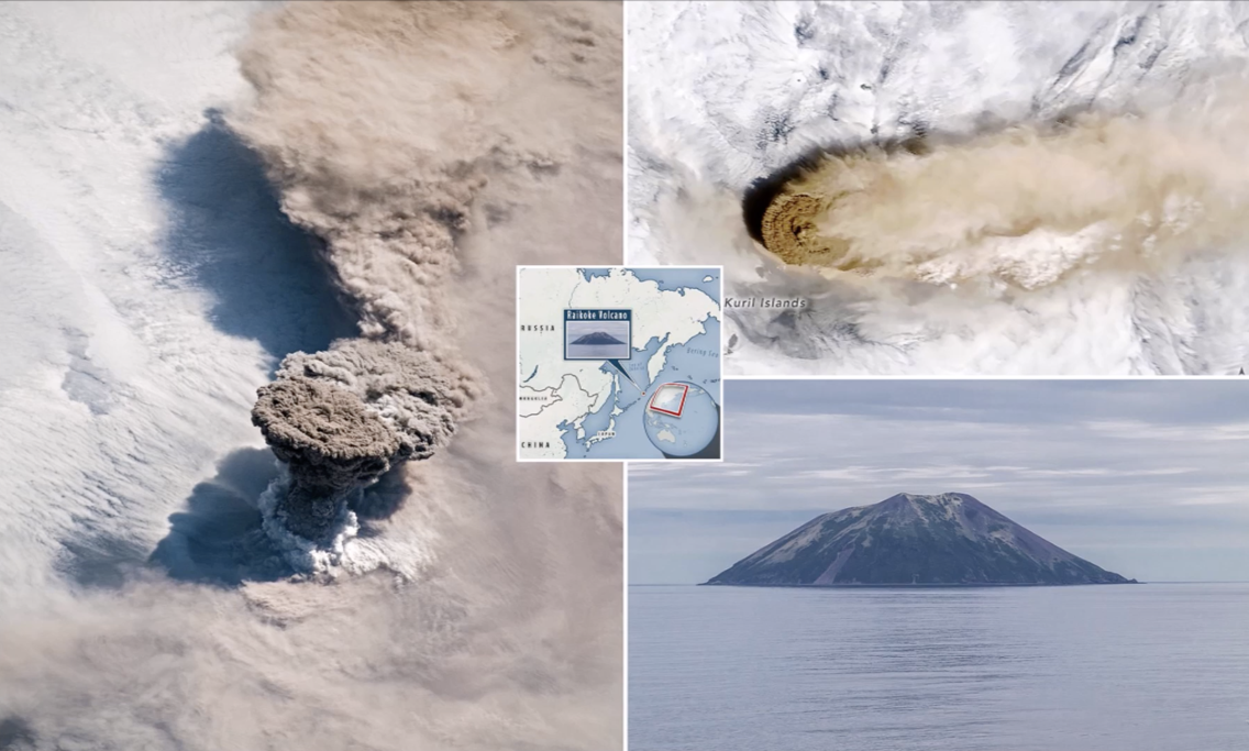
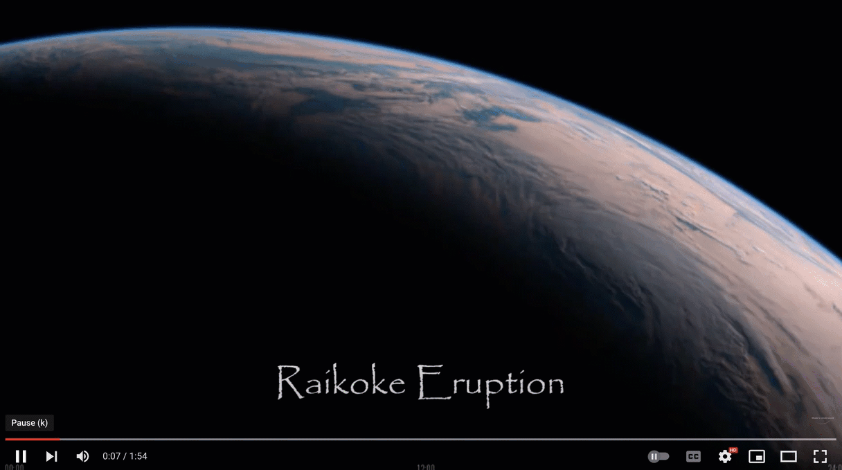
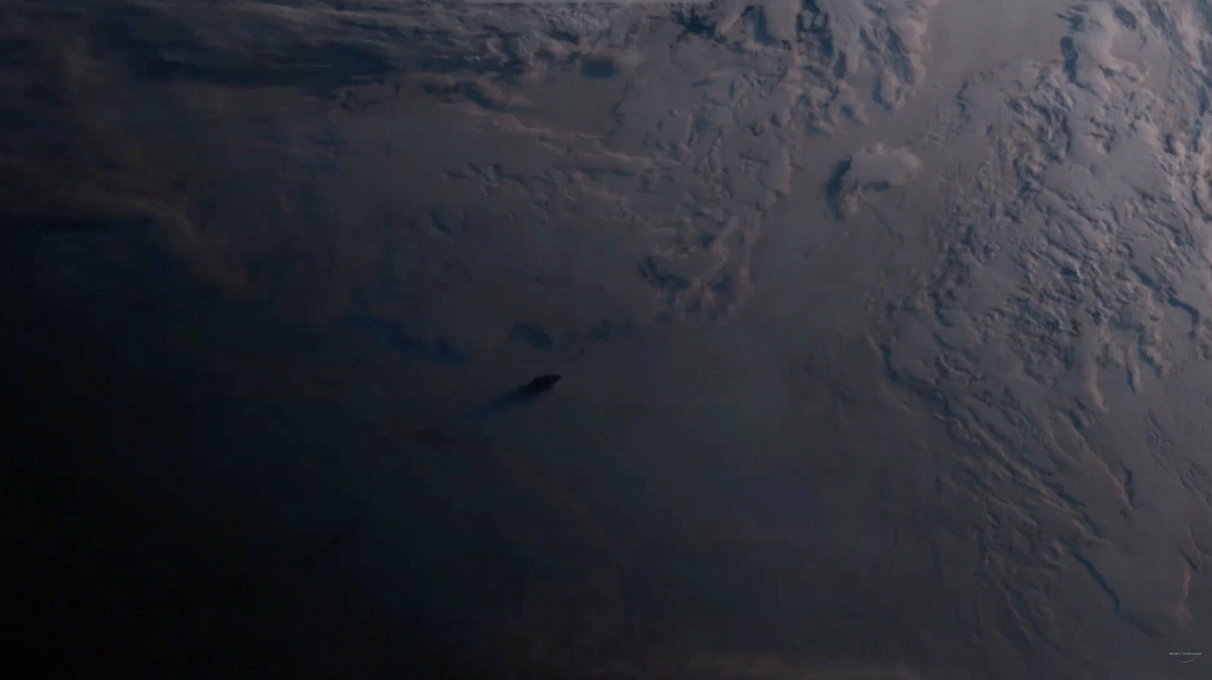
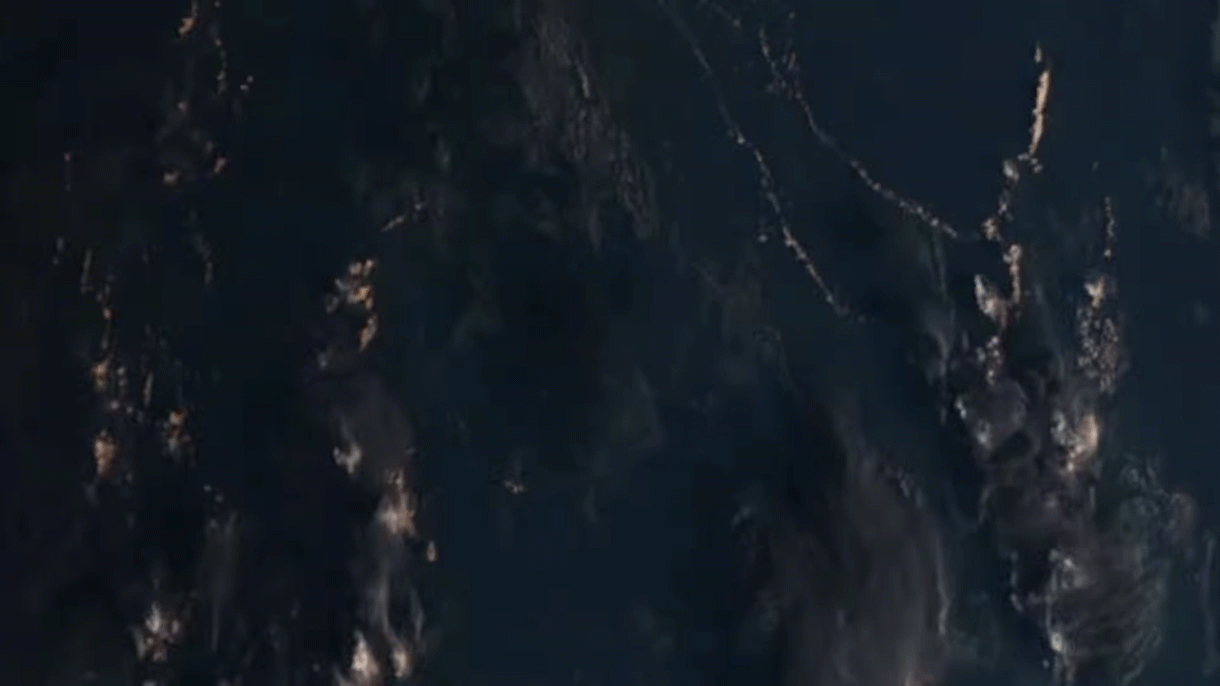
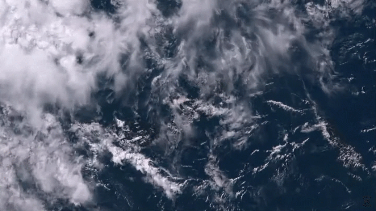
RAIKOKE VOLCANIC Eruption seen from Space 🌋 Himawari 8 & the ISS
Eruption of Mt Sinabung in Indonesia from Himawara 8
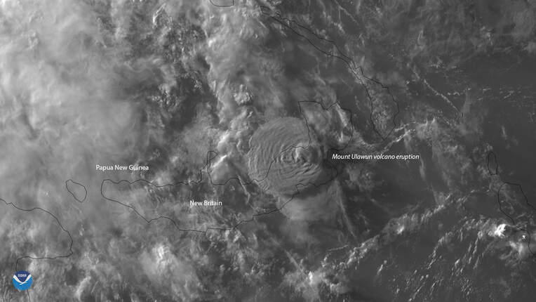
Himawari-8 Sees Volcanic Cloud from Mt. Ulawun Eruption
About 5,000 people in June 2019 were forced to flee their homes Wednesday, June 26, 2019, when Mount Ulawun on the island of New Britain in Papua New Guinea erupted. Himawari-8 saw this volcanic cloud, which reached a maximum height of 22 kilometers or more than 13 miles,
About 5,000 people in June 2019 were forced to flee their homes Wednesday, June 26, 2019, when Mount Ulawun on the island of New Britain in Papua New Guinea erupted. Himawari-8 saw this volcanic cloud, which reached a maximum height of 22 kilometers or more than 13 miles,
Annular Solar Eclipse “Ring of Fire” seen from space | Himawari 8
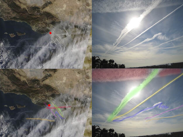
FLAT EARTH debunked by HIMAWARI 8 ground observationsAn observation Wade's Underground did matching his local weather with images from Himawari 8.
The popular flat earth argument that satellites images are cgi or fake or doppler is completely debunked by this observation. Matching satellite images with ground based observations.
The popular flat earth argument that satellites images are cgi or fake or doppler is completely debunked by this observation. Matching satellite images with ground based observations.