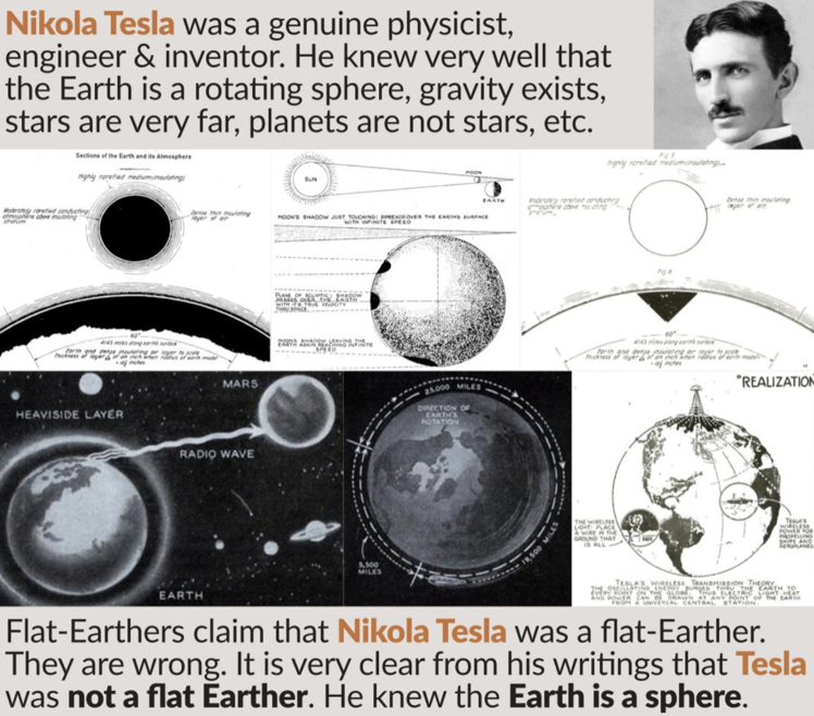
|
Maps, Flights & Expeditions
Flat earth map itself is evidence of a spherical earth Countries the right size on spherical earth. Southern hemisphere countries too big Antartica makes sense Crossing the Continent of Antarctica Many people have visited the Geographic South Pole Flights paths take great circles |
Artificial Horizon in Planes
Polar circumnavigation Marine radars Antipodal Flights (ie Auckland to Madrid) Emergency Landings geodetic survey Vasco Da Gama Great Circles Southern Hemisphere: Where Many Flat Earth Claims fall apart) |
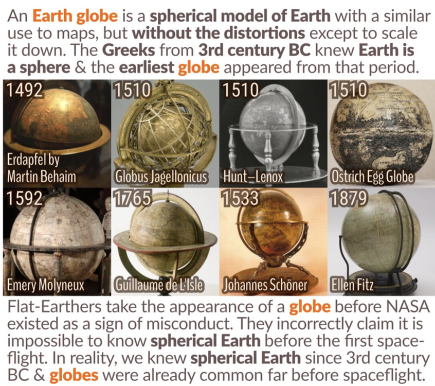
Every 2D map starts with the same lie: The earth is flat. The globe isn’t a portable, affordable, or even satisfying way to look at the world, so these exaggerations are necessary. However, mapmakers have challenged isolated the nature of these distortions
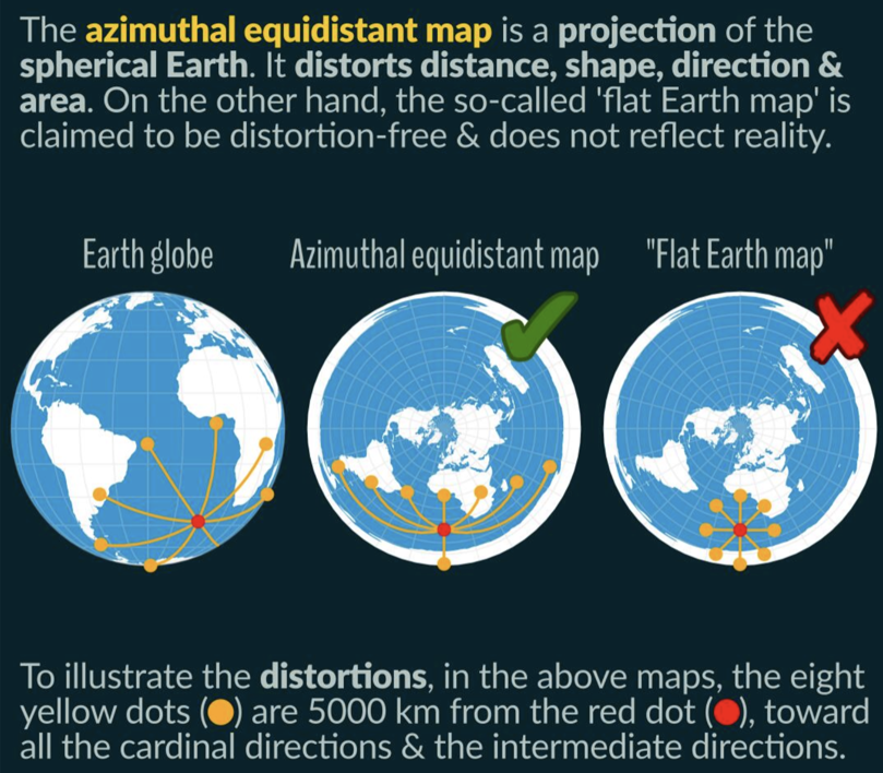
So let's look at the flat earth map. This is just an azimuthal equidistant projection of the globe. That is right, the flat earth map is a map of the globe taken from the perspective of looking down at the North Pole, and flattening out its surface into a plane so that a three dimensional surface can be shown in two dimensions. We can see everything at once, but it is distorted with no consistent scale. The further away from the center you go, the more significant the distortion, so problems really arise in the Southern Hemisphere. That is where the flights come in. This map is indeed a legitimate projection of the spherical Earth, but that is all it is: a projection.

|
|
No accurate flat earth map. If Earth were relatively 2-dimensional geometry, then well-established geographical dimensions should appear proportionately correct on a 2-dimensional map. But they do not at all. The flat Earth map grossly distorts continents, and inexplicably stretches longitude and latitude lines to fit.
Russia is known to be 6,000 miles long, and Australia is about 2,500 miles long, but on the flat map, Australia is as large as Russia! How would you account for this discrepancy? Here is a flat Earth map with continental dimensions preserved- It is geometrically impossible to accurately fit Earth geography into a 2D disc shape, because Earth is a sphere. It is like trying to make a deflated basketball lay flat with all of the skin facing up.
Russia is known to be 6,000 miles long, and Australia is about 2,500 miles long, but on the flat map, Australia is as large as Russia! How would you account for this discrepancy? Here is a flat Earth map with continental dimensions preserved- It is geometrically impossible to accurately fit Earth geography into a 2D disc shape, because Earth is a sphere. It is like trying to make a deflated basketball lay flat with all of the skin facing up.
Great circle courses shortest distances between two points PROVES the Earth is a Sphere!
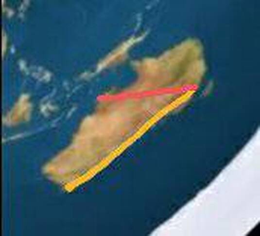
The Southern Hemisphere is a big problem for Flat earthers. That is where everything 'blows up' on their map and cosmology. They have no rational answer and resort to ludicrous and nonsensical conspiracy, perspective, refraction etc arguments.
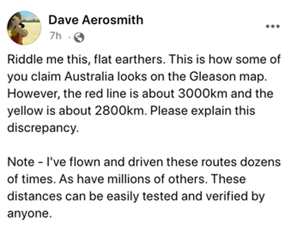
Melbourne to Darwin is the red line, Melbourne to Perth is the yellow line.
The Southern Hemisphere is a big problem for Flat earthers. That is where everything 'blows up' on their map and cosmology. They have no rational answer and resort to ludicrous and nonsensical conspiracy, perspective, refraction etc arguments.
Melbourne to Darwin is the red line, Melbourne to Perth is the yellow line.
|
|
https://en.wikipedia.org/wiki/Earth_radius
|
|
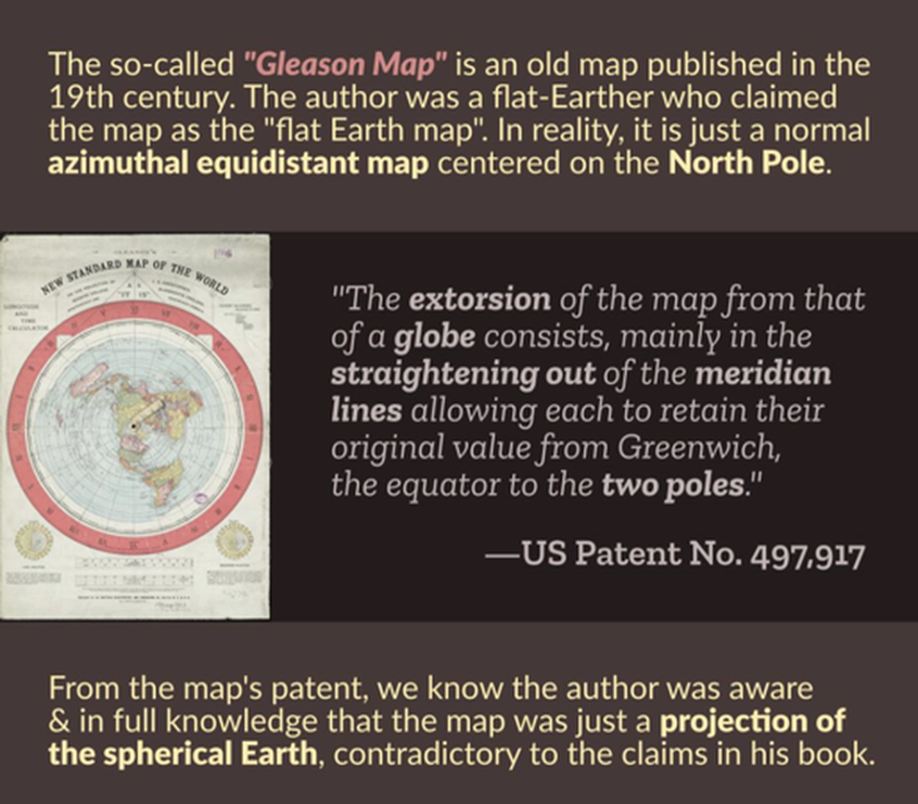
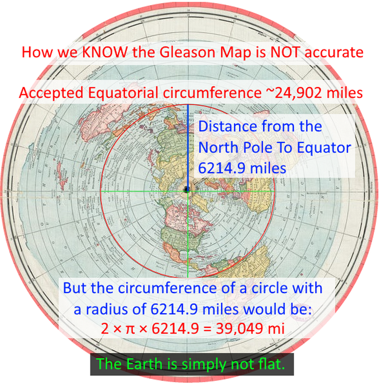
The Gleason Map does NOT represent the Reality We Live In!
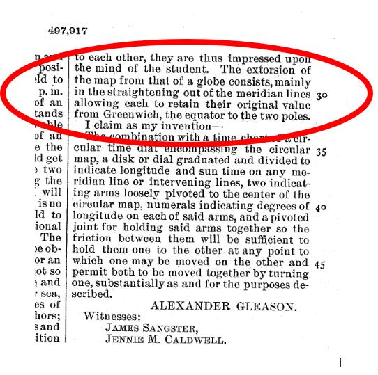
Why does the Equatorial radius and circumference only work on a Globe?
Take some time to really ponder the truth shown here on the well accepted flat earth Gleason Map. There is no way this map represents the reality we live in.
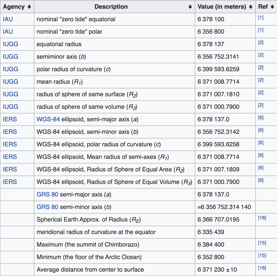
The radius of the earth from the pole to the equator is very precisely known. If you do not believe this known radius for some reason, you can see around 20 studies confirming the radius precisely at the link below:
https://en.wikipedia.org/wiki/Earth_radius
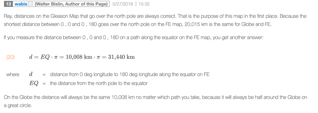
Knowing this radius we can calculate the great circle distance from the North Pole to the equator which is simply just 1/4 the circumference around the world. Very easy math here. So this great circle distance is in blue on this image which of course is simply a line on a 2D map. Now just do π*r^2 to get the radius of the equator and you'll find on the Gleason map it would HAVE TO BE over 39,000 miles! Even if our very precise modern measurements were off a little, they are likely only off a mile or so, NOT 14,000 MILES!!
This is an epic fail for the flat earth conjecture. There is no way this map represents reality.
Why does the Equatorial radius and circumference only work on a Globe?
Take some time to really ponder the truth shown here on the well accepted flat earth Gleason Map. There is no way this map represents the reality we live in.
The radius of the earth from the pole to the equator is very precisely known. If you do not believe this known radius for some reason, you can see around 20 studies confirming the radius precisely at the link below:
https://en.wikipedia.org/wiki/Earth_radius
Knowing this radius we can calculate the great circle distance from the North Pole to the equator which is simply just 1/4 the circumference around the world. Very easy math here. So this great circle distance is in blue on this image which of course is simply a line on a 2D map. Now just do π*r^2 to get the radius of the equator and you'll find on the Gleason map it would HAVE TO BE over 39,000 miles! Even if our very precise modern measurements were off a little, they are likely only off a mile or so, NOT 14,000 MILES!!
This is an epic fail for the flat earth conjecture. There is no way this map represents reality.
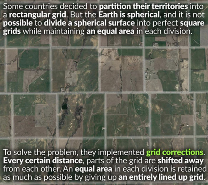
Some countries decided to partition their territories into a rectangular or square grid. But the Earth is spherical, and it is not possible to divide a spherical surface into a perfect rectangular grid while maintaining the perfect angles, distances, and areas.
To solve this problem, land surveyors implemented grid corrections. Every certain distance, parts of the grid are shifted away from each other. Therefore, an equal area in each division is maintained as much as possible by giving up an entirely lined up grid.
To solve this problem, land surveyors implemented grid corrections. Every certain distance, parts of the grid are shifted away from each other. Therefore, an equal area in each division is maintained as much as possible by giving up an entirely lined up grid.
- Gerco de Ruijter Grid Corrections
- US road grid corrections because of the Earth’s curvature – Kottke.org
- Public Land Survey System – Wikipedia
- Rectangular Survey System – Landprints
- What Happens When The Grid Meets The Curvature of the Earth? – Amusing Planet
- Mysterious Detour While Driving? It Could Be Due to the Curvature of the Earth – Travel+Leisure
- Kansas’ Roads Are All Goofy Because Nature Always Pwns Logic – Wired
|
|