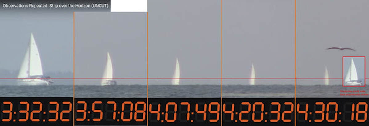
Due to Earth’s curvature, ships traveling over an ocean disappear from the bottom up.
This fact is one of the first evidence to confirm the Earth is a sphere, and one of the first facts of which flat-Earthers had to invent various “explanations” for.
Refraction: Refraction cannot make ships disappear bottom first and still maintain a clearly defined horizon.
Perspective: Perspective does not make an object to appear obstructed by another object. An object has to be behind another to appear obstructed.
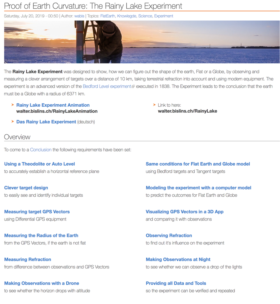
If a distant boat is not visible, then it is because of at least one of these reasons:
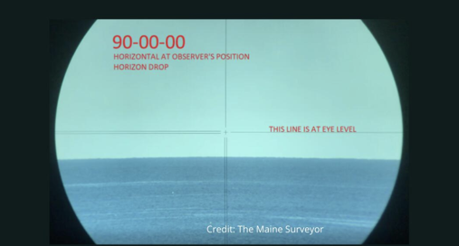
The Horizon is a result of the curve, if the earth was flat there would be a blurred horizon!]
This fact is one of the first evidence to confirm the Earth is a sphere, and one of the first facts of which flat-Earthers had to invent various “explanations” for.
Refraction: Refraction cannot make ships disappear bottom first and still maintain a clearly defined horizon.
Perspective: Perspective does not make an object to appear obstructed by another object. An object has to be behind another to appear obstructed.
If a distant boat is not visible, then it is because of at least one of these reasons:
- Our eyes have limited angular resolution and are unable to resolve the ship at that distance.
- The atmospheric condition is limiting our visibility.
- The curvature of the Earth obscures the ship
The Horizon is a result of the curve, if the earth was flat there would be a blurred horizon!]
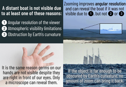
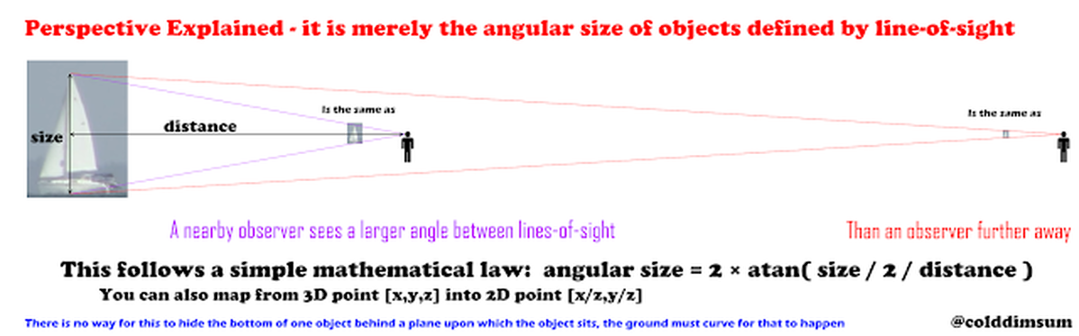
If this were perspective the boat would just appear smaller, we wouldn't be missing half the boat (like boat on far right below). But we know it sinks!
This is because perspective is just a consequence of the line-of-sight changing angles as an object recedes from an observer.
This is because perspective is just a consequence of the line-of-sight changing angles as an object recedes from an observer.
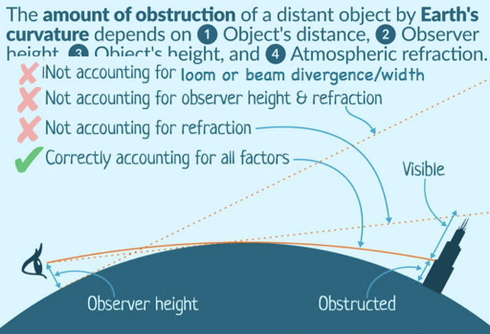
Misconception: “X is visible from Y distance, therefore the Earth is flat.”
These claims very often miss a lot of critical pieces of information. In order to do these calculations you at least need the height of the observer. That way you can calculate the distance to the horizon. Even if the observed object is further away than the horizon, it can still be observed if it’s tall enough.
http://walter.bislins.ch/bloge/index.asp?page=Comparison+of+Globe+and+Flat-Earth+Model+Predictions+with+Reality
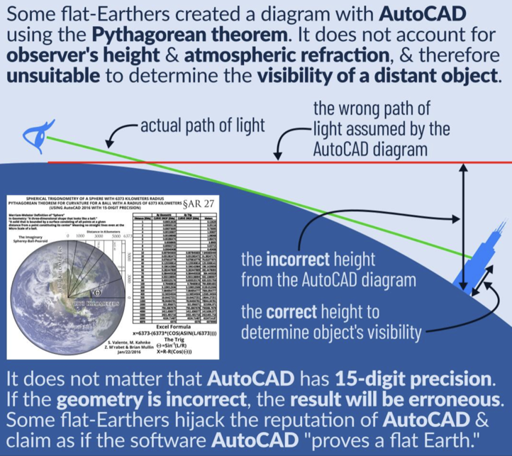
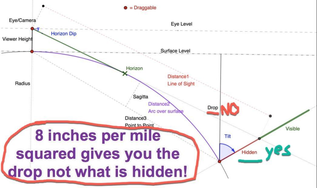
Fallacy of Overprecision
The diagram only accounts for the distance, failing to consider the observer’s height and refraction. Thus, the numbers will be wrong. And no amount of extra digits will make it any more valid.
The diagram only accounts for the distance, failing to consider the observer’s height and refraction. Thus, the numbers will be wrong. And no amount of extra digits will make it any more valid.
|
|
Accurate up to 100 miles - No Disagreement
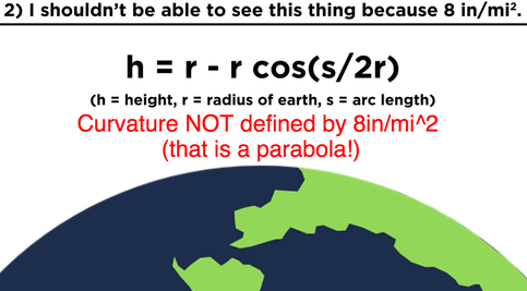
From this is it easy to see that [8"×d²] is somewhat accurate for distances up to about 100 miles and then it is absolutely terrible after that. And now we know why - they threw out all the little corrections in the Taylor series that keep it accurate in order to make a simple "rule" that was "good enough" for what they needed at the time.
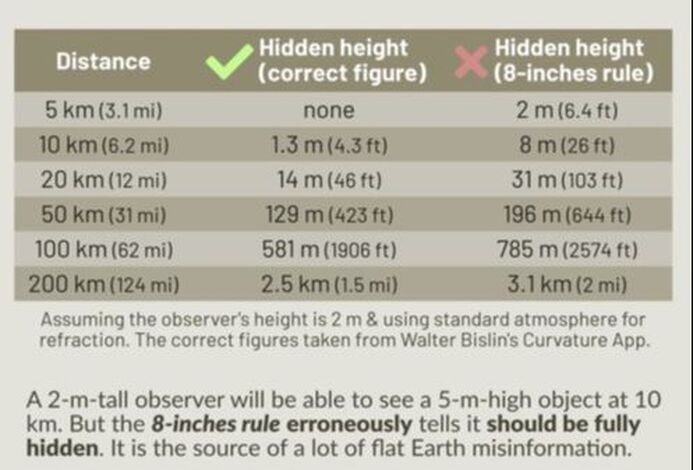
But this approach contains three gross errors
1) It does not account for the height of the observer
2) It does not take into account that in reality, the observer must look towards the horizon (Horizon Does NOT meet eye level).
3) It does not account for refraction
4) This results in an erroneously larger hidden height than the correct amount.
Websters dictionary definition #1.
What is the vertical temperature gradient.
Poor quality.
Does it get a lot closer
1 degree Celsius in a just a couple inches.
Frozen lake is the most refractive
Measure
Light is bending more than the radius of the earth.
1 degree per 10 meters.
From this is it easy to see that [8"×d²] is somewhat accurate for distances up to about 100 miles and then it is absolutely terrible after that. And now we know why - they threw out all the little corrections in the Taylor series that keep it accurate in order to make a simple "rule" that was "good enough" for what they needed at the time.
But this approach contains three gross errors
1) It does not account for the height of the observer
2) It does not take into account that in reality, the observer must look towards the horizon (Horizon Does NOT meet eye level).
3) It does not account for refraction
4) This results in an erroneously larger hidden height than the correct amount.
Websters dictionary definition #1.
What is the vertical temperature gradient.
Poor quality.
Does it get a lot closer
1 degree Celsius in a just a couple inches.
Frozen lake is the most refractive
Measure
Light is bending more than the radius of the earth.
1 degree per 10 meters.
|
|
|

|
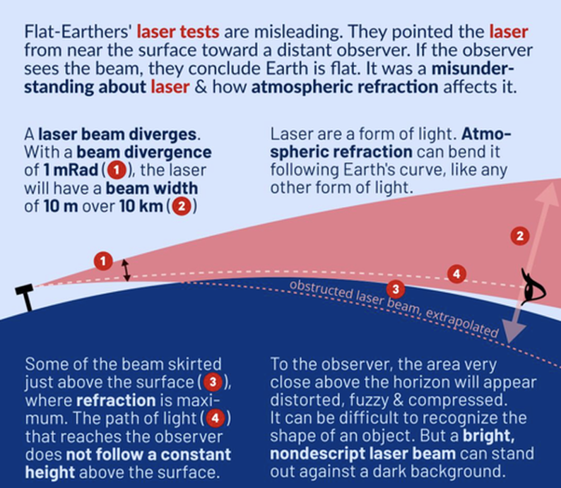
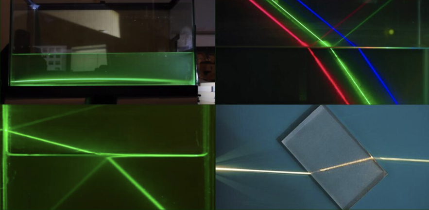
Bogus Laser Beam Experiments
The main contribution it has to the results being misleading is that it extends the beam downward. So if they have a beam that is parallel to the ground, there's always going to be a light path that goes directly to just skimming the horizon, the region of greatest refraction. The yellow line in the video
The main contribution it has to the results being misleading is that it extends the beam downward. So if they have a beam that is parallel to the ground, there's always going to be a light path that goes directly to just skimming the horizon, the region of greatest refraction. The yellow line in the video
|
|
|
|
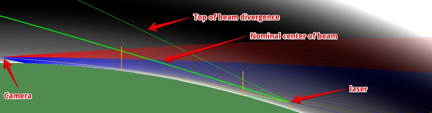
All laser experiments beyond the immediate land-water horizon (about 3 - 5 miles) are invalid because of:
a) laser beam divergence / expansion
b) atmospheric refraction
c) atmospheric interference from all kinds of distortions
Laser test are subject to atmospheric distortions of many kinds. It's not possible to subtract those effects out:
temperature inversion (warm over cold dense air, greater the difference the greater the distortion & possibility of atmospheric ducting
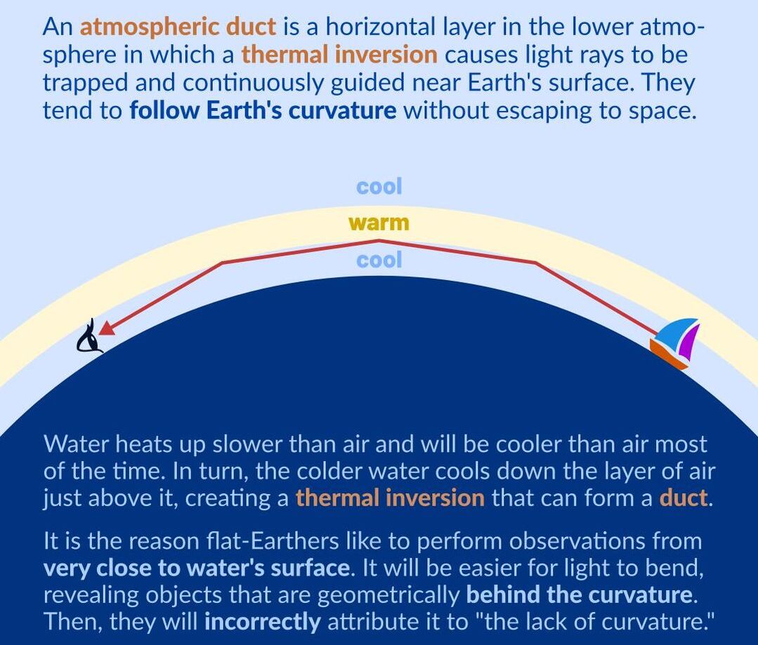
an atmospheric duct is a horizontal layer in the lower atmosphere in which the vertical refractive index gradients are such that radio signals (and light rays) are guided or ducted, tend to follow the curvature of the Earth, and experience less attenuation in the ducts than they would if the ducts were not present.
atmospheric looming, sinking, towering & stooping
inferior mirage, superior mirage, and Fata Morgana
standard atmospheric refraction
There is no need for long distance laser experiments. Anyone can prove flatness or curvature within the first 5-km.
Observer height:
1-meter laser height to 3.6-km limit
2-meter laser height to 5.1-km limit
5-meter laser height to 8-km limit
Due to a normal temperature gradient found in the atmosphere, light rays are bent 1/5 or 1/6 the Earth’s curvature.
With a temperature inversion (increase or decrease) of 6.3o F per 100-feet, the curvature of a light ray is of the same order as the curvature of the Earth.
a) laser beam divergence / expansion
b) atmospheric refraction
c) atmospheric interference from all kinds of distortions
Laser test are subject to atmospheric distortions of many kinds. It's not possible to subtract those effects out:
temperature inversion (warm over cold dense air, greater the difference the greater the distortion & possibility of atmospheric ducting
an atmospheric duct is a horizontal layer in the lower atmosphere in which the vertical refractive index gradients are such that radio signals (and light rays) are guided or ducted, tend to follow the curvature of the Earth, and experience less attenuation in the ducts than they would if the ducts were not present.
atmospheric looming, sinking, towering & stooping
inferior mirage, superior mirage, and Fata Morgana
standard atmospheric refraction
There is no need for long distance laser experiments. Anyone can prove flatness or curvature within the first 5-km.
Observer height:
1-meter laser height to 3.6-km limit
2-meter laser height to 5.1-km limit
5-meter laser height to 8-km limit
Due to a normal temperature gradient found in the atmosphere, light rays are bent 1/5 or 1/6 the Earth’s curvature.
With a temperature inversion (increase or decrease) of 6.3o F per 100-feet, the curvature of a light ray is of the same order as the curvature of the Earth.
Navy Submarine RADAR History, Earth Curvature
In 'History of Airborne and Shipboard Periscope Detection Radar Design and Developments' we see the following in a discussion about radar horizon:
Not surprisingly, the radius of the earth enters into calculations of the geometrical range to the horizon; calculations of the range to the radar horizon account for refraction by assuming that the radius of the earth is 4/3 as great as its actual value. For sensor altitudes small in comparison with the radius of the earth, the distance to the radar horizon in nautical miles is 1.23 times the square root of the altitude in feet. Thus, for a typical airborne PDR altitude of 500 feet, the range to the radar horizon is 27.5 nmi, and for a nominal mast-mounted shipboard antenna height of 70 ft, it is about 10 nmi. Note that common surveillance radar heights for a U.S. cruiser or destroyer are 100-120 ft, and, for an aircraft carrier, 150-180 ft.
Just another nail in the coffin of claims that nobody ever takes curvature of the Earth into account.
Pretty much every book on RADAR discusses both the effect of Earth curvature and refraction on RADAR.
Flat Earth, I see this thing and I shouldn't "tests"...
Getting Debunked since 1870!
But this is an unrepeatable experiment, there is no evidence supporting this claim. Someone claiming what they saw is not evidence - just look at how many claims in this series that are easy to test have been shown to be false. Maybe they were only 20 miles away? 30 miles?
Unlike other examples, there is no landmark given that I can verify in this case.
JTolan Media Debunked by
FTFE
MCtoon
Bob the science guy
The Curve Over Water
https://jessekozlowski.wordpress.com/2020/04/04/the-earths-curvature-plainly-visible/
JTolan Media Debunked
|
|
Extreme bending of light can happen near surface layers of the earth.
Thousands of geodetic surveyors measured the curvature of the earth all over the world since centuries for a living. Their results are essential in many fields. Wrong measurements would be obvious and not accepted by anyone.
Flat earther first have to learn how experiments are done. They not only have no model, can't make any predictions for what they should expect to measure, nor do they measure anything. This is not even pseudo science. This is confirmation bias!
All the flat earth laser and mirror experiments are done in the surface layer near the ground where refraction is the strongest as you can see as inferior mirages and compressions that are only visible directly above the surface. Surface refraction bends light along the curvature of the earth for hundreds of miles as soon as the surface is colder than the air above. I have observed such an extreme phenomenon over a frozen lake on Strong Refraction at Bedford Targets, where the earth appeared even convex.
This extreme bending of light is a well known fact by seafarers and geodetic surveyors. Go higher where refraction is minimal (standard refraction), out of the surface layer, and you will see that all observations match the predictions of the Curvature Calculators taking refraction into account.
Geodetic surveyors never measure Geodetic control networks in the surface layer. They have built high survey towers to get out of the ground layer for a reason. See also Refraction Coefficient as a Function of Altitude.
https://jessekozlowski.wordpress.com/2020/02/19/refraction-references/
Seeing/Curvature
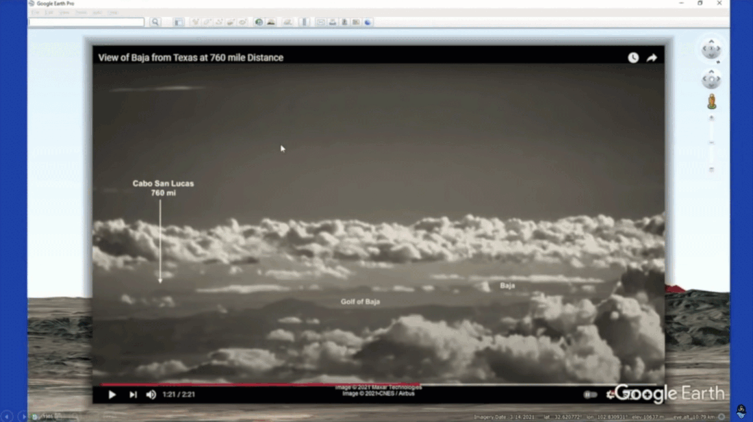
NASA photos from space including 2015
Curvature studies
Observing Earth's Curvature from Near the Surface
Climbing Higher
Seeing the curve - Concorde/Boom/Virgin flights (window rebuttal)
(Observing Earth’s Curvature on a Flight)
Seeing the curve ISS - 248 people including civilians (all liars?)
ISS speed and trajectory match perfectly spherical earth
Horizon experiments even with P900
Curvature of the Horizon in High-Altitude Balloon Footage
Telephoto lenses - ultra wide lens (left right curvature) vs telescopic (front-back curvature)
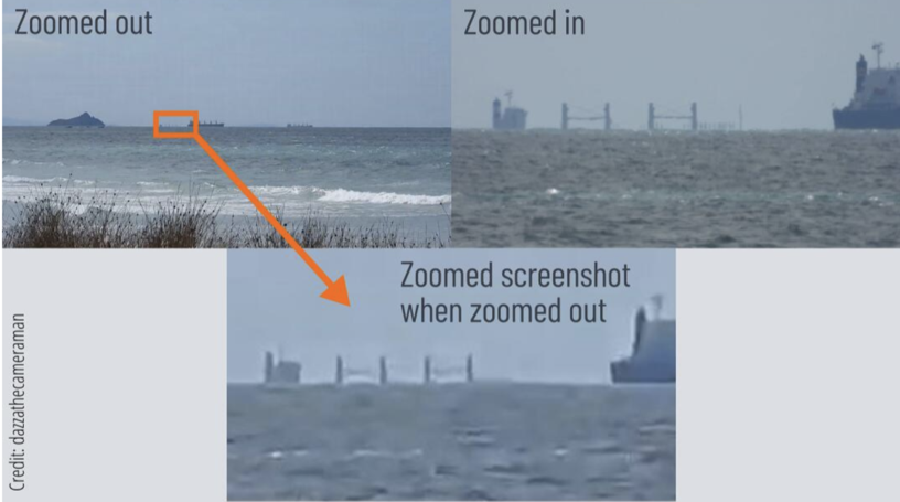
Zooming in on a Partially Obscured Ship
Flat earth laser and camera images are debunked
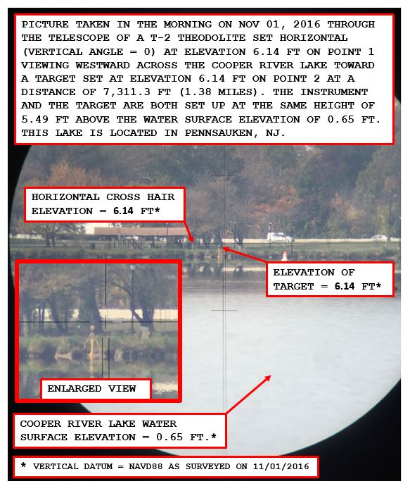
Theodolite and the Dip of the Horizon
Pilots things coming into view
flat-horizon - And we can sometimes see a very clear horizon if the distance to the horizon is well within our visibility range. If the Earth is flat, we would never be able to see a clear horizon, and the horizon will always be blurry.
Explains superior mirage
Explains why things do not vanish smaller and smaller
Flerspective - Invented explanation of why bottom part is clipped.
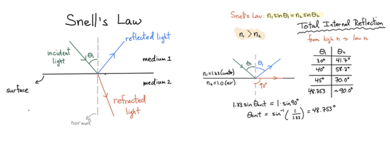
Refraction effects and Snells Law (Unrealistic angles)
Atmospheric Refraction and the Position of the Sun in the Flat-Earth Model (.57%)
Water Level Demonstrates The Dip of the Horizon and Proves Earth’s Curvature
Crow’s Nest on Ships
(Black swan case study)
(Toronto Case Study)
Lake Pontchartrain Power Transmission Lines: Evidence of Earth’s Curvature
Evidence of Curvature: Turning Torso Building, Malmö, Sweden
Atchafalaya Basin Observations: Curved Water Found
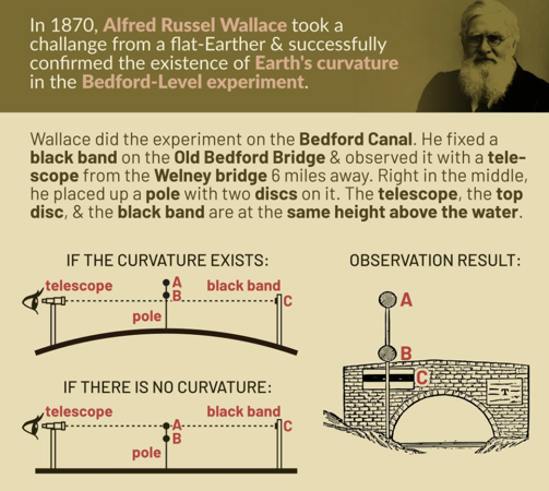
Bedford Level Experiment Confirmed the Curvature of the Earth
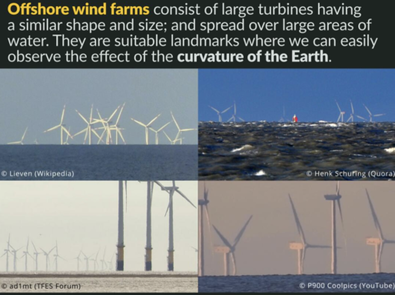
Thorntonbank Wind Farm (near the Belgian coast)
An image of Thorntonbank Wind Farm (near the Belgian coast) with the lower parts of the more distant towers increasingly hidden by the horizon, demonstrating the curvature of the Earth!
kansas pancake
Salt flats
Suspension Bridges Curvature (Humber Bridge)
Railroad tracks Curvature
Leveling and Surverying
Al-Biruni’s Method to Determine the Radius of the Earth
biot-arago
Curvature Analysis - Behind the Curve
Earth's Curvature Calculation
**Dizzibs calculator no refraction - Use Metabunks or Walter Bislins
Curvature app - http://walter.bislins.ch/curve
Other demonstrations (??)
The altitude of the observer.
The field of view of the camera.
Lens distortions of the camera.
NASA photos from space including 2015
Curvature studies
Observing Earth's Curvature from Near the Surface
Climbing Higher
Seeing the curve - Concorde/Boom/Virgin flights (window rebuttal)
(Observing Earth’s Curvature on a Flight)
Seeing the curve ISS - 248 people including civilians (all liars?)
ISS speed and trajectory match perfectly spherical earth
Horizon experiments even with P900
Curvature of the Horizon in High-Altitude Balloon Footage
Telephoto lenses - ultra wide lens (left right curvature) vs telescopic (front-back curvature)
Zooming in on a Partially Obscured Ship
Flat earth laser and camera images are debunked
Theodolite and the Dip of the Horizon
Pilots things coming into view
flat-horizon - And we can sometimes see a very clear horizon if the distance to the horizon is well within our visibility range. If the Earth is flat, we would never be able to see a clear horizon, and the horizon will always be blurry.
Explains superior mirage
Explains why things do not vanish smaller and smaller
Flerspective - Invented explanation of why bottom part is clipped.
Refraction effects and Snells Law (Unrealistic angles)
Atmospheric Refraction and the Position of the Sun in the Flat-Earth Model (.57%)
Water Level Demonstrates The Dip of the Horizon and Proves Earth’s Curvature
Crow’s Nest on Ships
(Black swan case study)
(Toronto Case Study)
Lake Pontchartrain Power Transmission Lines: Evidence of Earth’s Curvature
Evidence of Curvature: Turning Torso Building, Malmö, Sweden
Atchafalaya Basin Observations: Curved Water Found
Bedford Level Experiment Confirmed the Curvature of the Earth
Thorntonbank Wind Farm (near the Belgian coast)
An image of Thorntonbank Wind Farm (near the Belgian coast) with the lower parts of the more distant towers increasingly hidden by the horizon, demonstrating the curvature of the Earth!
kansas pancake
Salt flats
Suspension Bridges Curvature (Humber Bridge)
Railroad tracks Curvature
Leveling and Surverying
Al-Biruni’s Method to Determine the Radius of the Earth
biot-arago
Curvature Analysis - Behind the Curve
Earth's Curvature Calculation
**Dizzibs calculator no refraction - Use Metabunks or Walter Bislins
Curvature app - http://walter.bislins.ch/curve
Other demonstrations (??)
The altitude of the observer.
The field of view of the camera.
Lens distortions of the camera.