
Actual Photos Taken of the Whole Earth
Why the Blue Marble is Definitive Proof We Live on a Globe!
On the screen it says it a composite.If you want to analyze photos, analyze a photo
That NASA says is a single frame Non composite photo.
There are many. Around 15,000 from Apollo era alone.
Those were taken on 3 inch film, wet developed in a dark room, and the original photographic slides are in a museum in Houston Texas.
If it is not good enough the high res. Bring along photo forensics. Scan them yourselves
Tiff files not compressed and our massive.
http://tothemoon.ser.asu.edu/gallery/Apollo/8/Hasselblad%20500EL%2070%20mm#AS08-14-2383
http://tothemoon.ser.asu.edu/gallery/Apollo/16/Hasselblad%20500EL%2070%20mm#AS16-120-19187
http://tothemoon.ser.asu.edu/gallery/Apollo/16/Hasselblad%20500EL%2070%20mm#AS16-118-18879
I have heard a lot of flat earthers say to me, and on video to show them just one non composite whole earth image from space and they'll become a believer in the globe. The irony is we have literally hundreds of thousands of such images, but if you take literal to the idea of a composite photo than that excludes all digital photos because digital photos combine red, green and blue. Absurdity at its worst, but I don't think most flat earthers would be this extreme. But we actually have actual images taken with a real old fashioned camera that were developed in a dark room. Not composite, certainly not CGI and most definitely not fake. While there were 6 Apollo missions landing people on the moon with hundreds of photos, I want to focus my attention on the most famous, the Blue Marble Image! Everything I say about this applies to the other Apollo photos and photos taken by other space agencies as well.

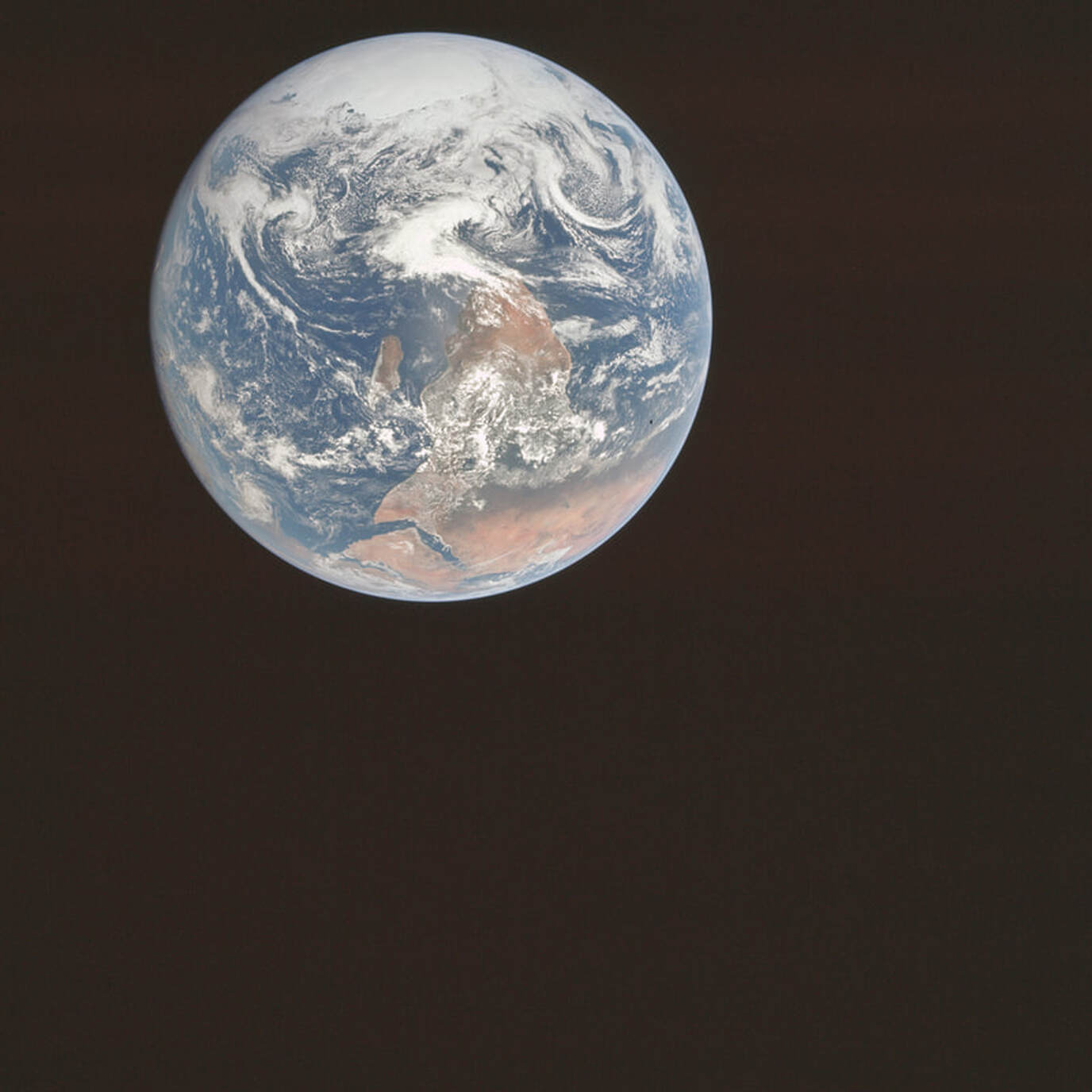
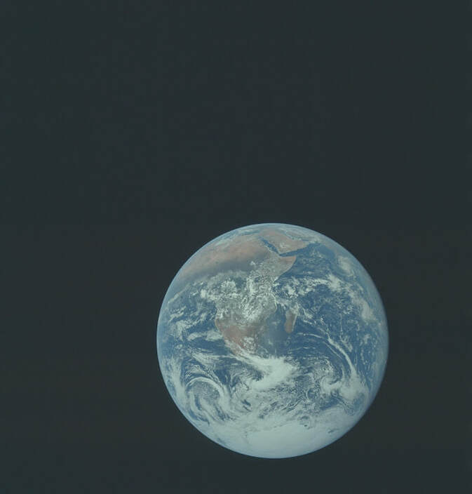
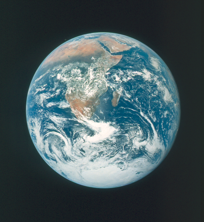
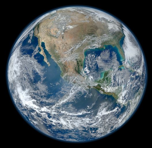
Apollo 17 Blue Marble original orientation (AS17-148-22727).jpg
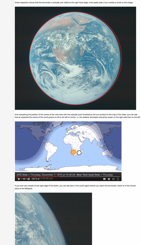
The Blue Marble is an image of Earth taken by the crew of the Apollo 17 spacecraft on its way to the Moon on Dec 7, 1972 at 5:40 am EST as the last of the Apollo missions. It was taken from a distance of 29000 km from Earth’s surface. The Apollo crew took this picture when they realized this will be the first time humans have ever seen the antarctic ice cap so they took that picture real quick and went back to work. It was also the first time a full disk image of the earth was ever taken with no phases and shadows.
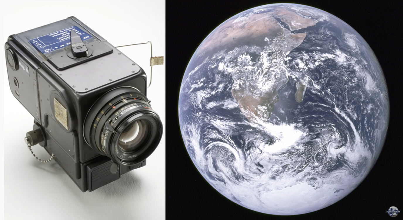
This is my favorite pic of earth from space. This image was taken by Harrison Schmitt (scientist/astronaut) with a hand-held Hasselblad 70 millimeter camera with an 80 millimeter lens. It is worth emphasizing that this is a real old fashioned camera and the image was developed in a dark room! The Original was upside down and the colors were a little flat but I prefer this image unedited over any other. It is so realistic looking it astounds me how anyone could claim this as a fake. Take some time and look at the high resolution version (link below). A remarkably cloud-free Africa is at upper left, stretching down to the center of the image. Saudi Arabia is visible at the top of the disk and Antarctica and the south pole are at the bottom. Asia is on the horizon is at upper right. Such Amazing detail of both the clouds and the land. You can even see the Tamil Nadu cyclone in the lower right of original or upper left of enhanced and cropped.
I found the original and unedited photo of the blue marble. That is why it is upside down, with no cropping, no enhancements, no alterations as least that is to the best of my research. ===> Source is HERE: https://www.lpi.usra.edu/.../images/print/AS17/148/22727.jpg
The Blue Marble is an image of Earth taken by the crew of the Apollo 17 spacecraft on its way to the Moon on Dec 7, 1972 at 5:40 am EST as the last of the Apollo missions. It was taken from a distance of 29000 km from Earth’s surface. The Apollo crew took this picture when they realized this will be the first time humans have ever seen the antarctic ice cap so they took that picture real quick and went back to work. It was also the first time a full disk image of the earth was ever taken with no phases and shadows.
This is my favorite pic of earth from space. This image was taken by Harrison Schmitt (scientist/astronaut) with a hand-held Hasselblad 70 millimeter camera with an 80 millimeter lens. It is worth emphasizing that this is a real old fashioned camera and the image was developed in a dark room! The Original was upside down and the colors were a little flat but I prefer this image unedited over any other. It is so realistic looking it astounds me how anyone could claim this as a fake. Take some time and look at the high resolution version (link below). A remarkably cloud-free Africa is at upper left, stretching down to the center of the image. Saudi Arabia is visible at the top of the disk and Antarctica and the south pole are at the bottom. Asia is on the horizon is at upper right. Such Amazing detail of both the clouds and the land. You can even see the Tamil Nadu cyclone in the lower right of original or upper left of enhanced and cropped.
I found the original and unedited photo of the blue marble. That is why it is upside down, with no cropping, no enhancements, no alterations as least that is to the best of my research. ===> Source is HERE: https://www.lpi.usra.edu/.../images/print/AS17/148/22727.jpg
** Blue Marble - The Flat Earth Killer Photo!**
Flat earthers hate this photo and they wish it never existed for a couple reasons:
1. It is taken with a real camera and developed in a dark room. Not digital! Not a painting! Not CGI! Not Fake! Not anything but a real full disk image of our spherical earth. If flat earth believers understood how ironclad of a proof of a spherical earth is, they would dump their nonsensical flat earth belief.
2. Another reason flat earthers' hate this image is that it was the first photo showing Antarctica from space, which shatters their entire flat earth model and there flat earth wall. The mere existence of the continent of Antarctica falsifies flat earth!
This one photo alone is a nail in the coffin of flat earth, and they know it, so they TRY cough up excuses (unsuccessfully) to discredit it.
I have heard a lot of things, but here are four objections I have come across.
1. They do their usual with photos from space and cry CGI, Fake, Painting. Composite Etc. But this is a REAL PHOTO developed in a darkroom. And there is ZERO, I mean ZERO proof it is fake! Using fotoforensics.com with a digital image is NOT PROOF! If you REALLY want to try to prove it is fake, get an original NASA red letter reprint of the photo and have a photo forensics expert show it is fake and could be shown to be fake in a court of law, otherwise shut up!)
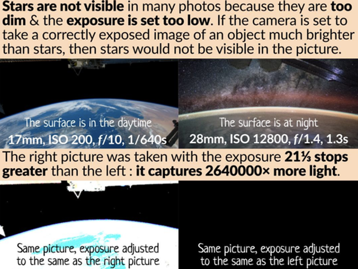
2. No stars in the background (common objection flat earthers whine about in all the images from space. This is due to exposure issues plain and simple. If the camera exposure was opened up to take images of the stars, the earth itself would be washed out.
Flat earthers hate this photo and they wish it never existed for a couple reasons:
1. It is taken with a real camera and developed in a dark room. Not digital! Not a painting! Not CGI! Not Fake! Not anything but a real full disk image of our spherical earth. If flat earth believers understood how ironclad of a proof of a spherical earth is, they would dump their nonsensical flat earth belief.
2. Another reason flat earthers' hate this image is that it was the first photo showing Antarctica from space, which shatters their entire flat earth model and there flat earth wall. The mere existence of the continent of Antarctica falsifies flat earth!
This one photo alone is a nail in the coffin of flat earth, and they know it, so they TRY cough up excuses (unsuccessfully) to discredit it.
I have heard a lot of things, but here are four objections I have come across.
1. They do their usual with photos from space and cry CGI, Fake, Painting. Composite Etc. But this is a REAL PHOTO developed in a darkroom. And there is ZERO, I mean ZERO proof it is fake! Using fotoforensics.com with a digital image is NOT PROOF! If you REALLY want to try to prove it is fake, get an original NASA red letter reprint of the photo and have a photo forensics expert show it is fake and could be shown to be fake in a court of law, otherwise shut up!)
2. No stars in the background (common objection flat earthers whine about in all the images from space. This is due to exposure issues plain and simple. If the camera exposure was opened up to take images of the stars, the earth itself would be washed out.

|
|
**Experiment to see no stars**
About the stars and it 100% being a limitation of photography. One thing I always tell flerfs is, go outside at night and take a wide angle photo of the moon and night sky. Count how many stars are in your photo. Very simple to understand experiment that flerfs can do to understand the limitation of photography vs the human eye. As an amateur astronomer I learned this very quickly trying to get photos of Jupiters colours & its 4 largest moons. Impossible to get both in one photo just like you observe through the eyepiece. It must be done with 2 overlapped composite photos with different exposure settings. I had ZERO photography experience before getting into astronomy so I had ALOT to learn before I could share these beautiful views I was seeing to family and friends to get them interested. Its not just as simple as point and click and get an image of exactly what your seeing.... not a chance lol
NO STARS - GREAT ARTICLE!!
https://www.planetary.org/articles/why-are-there-no-stars
The next objection is that the proportions of Africa are too big and flat earthers dismiss it by incorrectly asserting that the image covers a too-small area of Earth’s surface, due to their failure to account for the maps’ distortion due to perspective which results from the distance away, field of view and camera used.
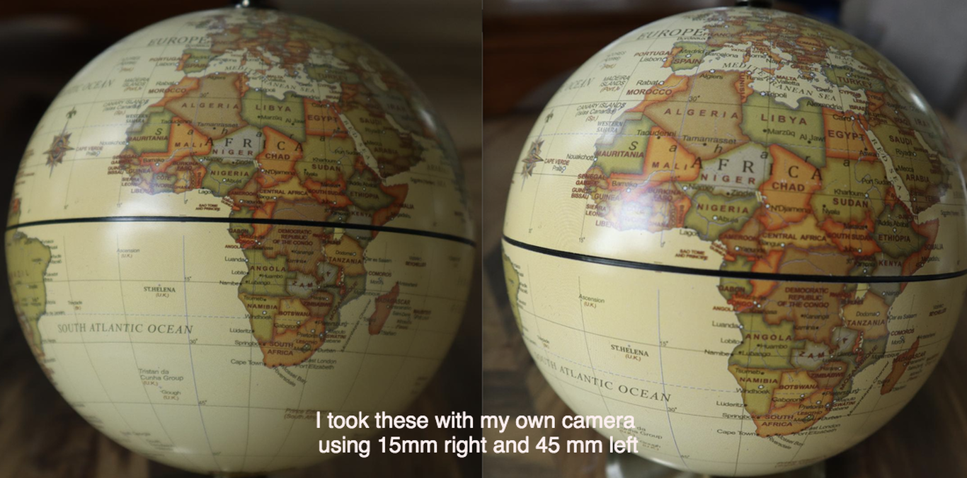
Perspective Effect - Anyone can prove this with a zoom camera and a globe.
Flat earthers' like to claim many images of earth from space like the blue marble have distorted continents that appear too big or too small therefore they must be fake. They even try to draw known distances not understanding perspective. You don't measure the height of the Eiffel tower when you take a photo with it between your fingers?
Well, this is easily debunked with a zoom camera and a globe. Here is an experiment I did with a 15mm and 45mm camera both up close and further away keeping the overall size of the globe the same. If I had a 200 mm camera it would even be more pronounced as is shown in this image taken by another person. It is really simple actually, you simply see more of the globe as you get further away, when you are up close (like Apollo was to a degree), you see less and continents like Africa appear bigger than they really are.
Like many such things, it's all about perspective, and the way our brains work. We look at these images of the Earth, and our brain thinks of it as a flat object. You'd think if you get close to something, then it will get bigger, but not change shape. But this breaks down for three dimensional objects. If you get close to a globe, then you can see less of it, so the visible objects seem a lot bigger relative to the visible disc of the globe. The part of the globe in the middle is also a lot closer to your eye (relative to the edges) so seems bigger, like it's bulging out more than it actually is. You can verify this yourself with a household globe and your eyes (or a camera)
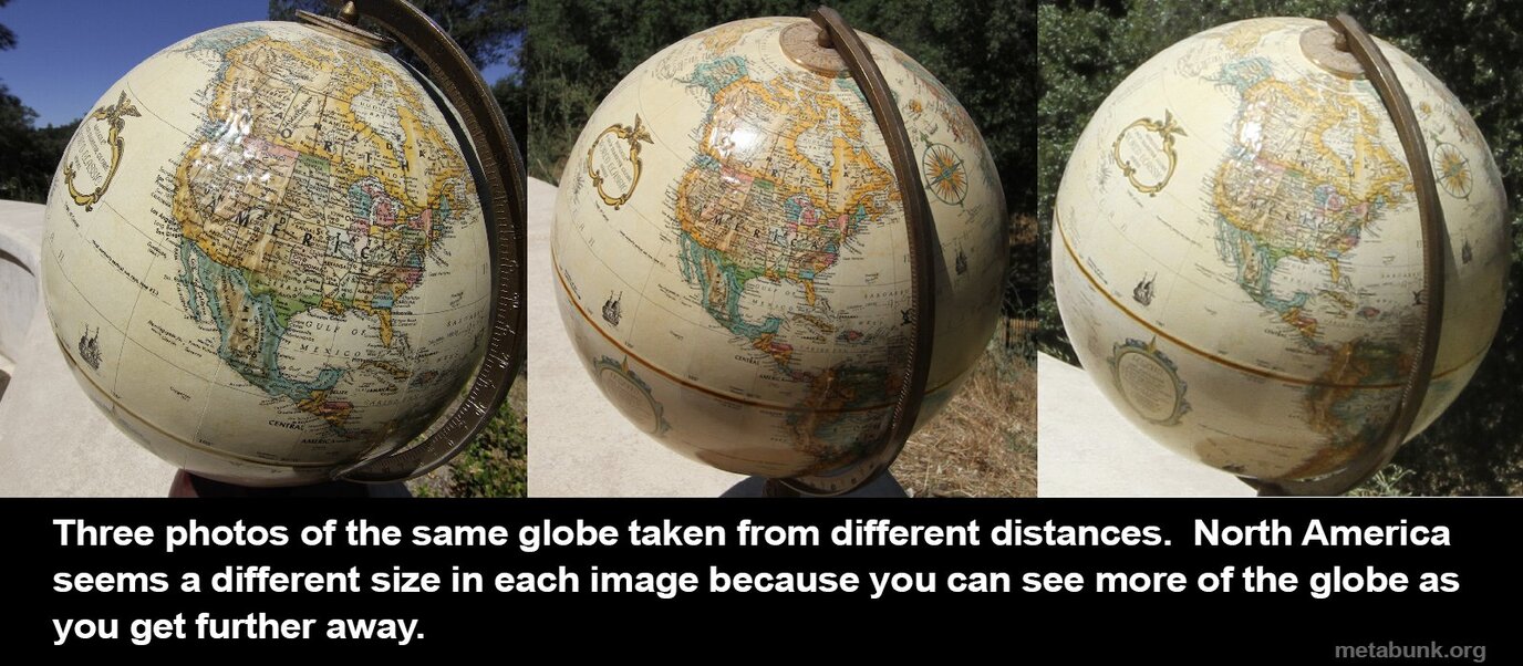
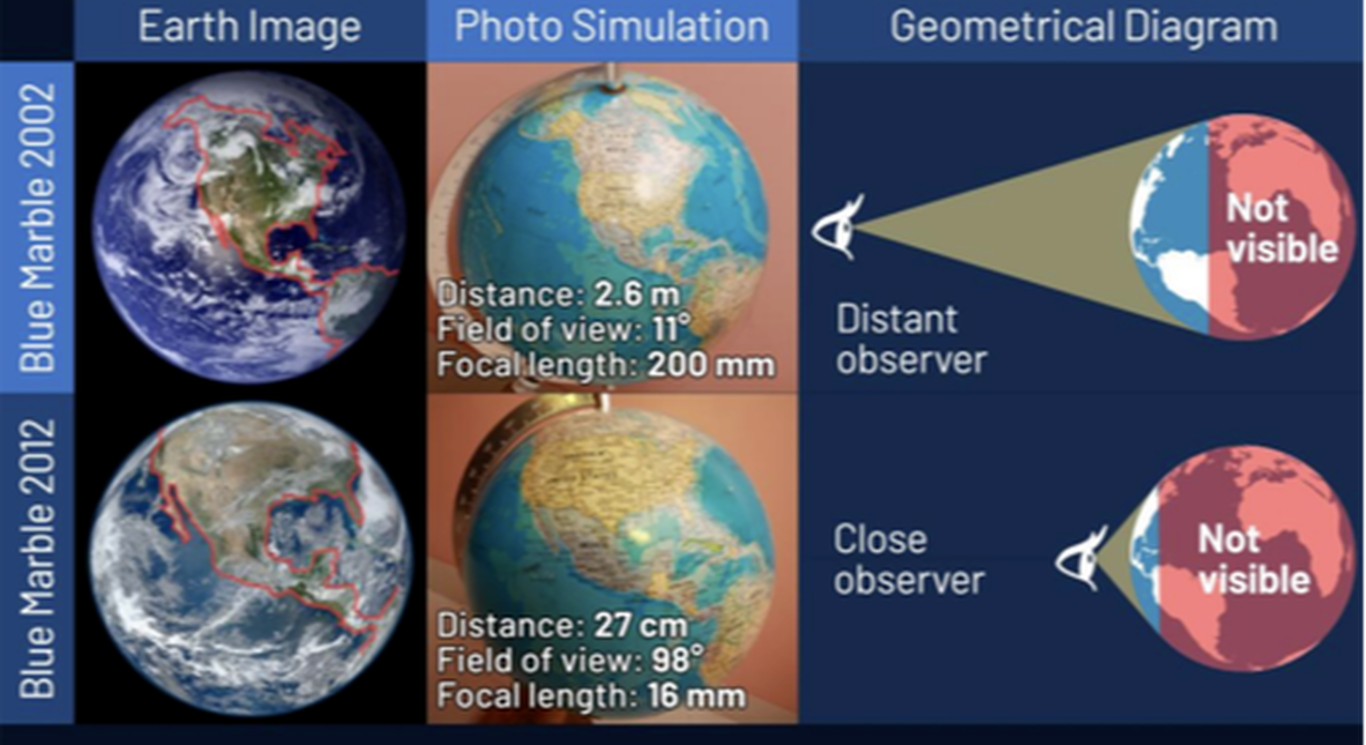
==>The close the camera to the Earth (or, in the above photos, to a globe), the smaller area of the globe surface it captures, therefore the continents in that area look bigger.
.
3. Walter Bislin on Perspective
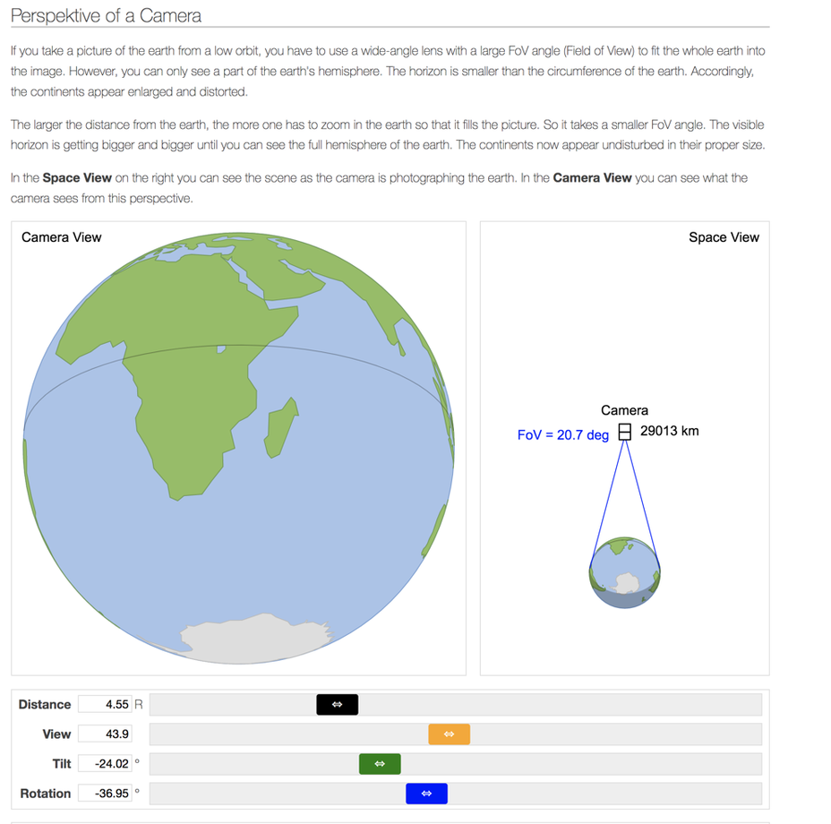
You can verify the image perspective by using Walter Bislin's EXCELLENT perspective tool!
http://walter.bislins.ch/bloge/index.asp?page=The+True+Face+of+the+Earth%2C+Camera+Distance+matters
You can verify the image perspective by using Walter Bislin's EXCELLENT perspective tool!
http://walter.bislins.ch/bloge/index.asp?page=The+True+Face+of+the+Earth%2C+Camera+Distance+matters
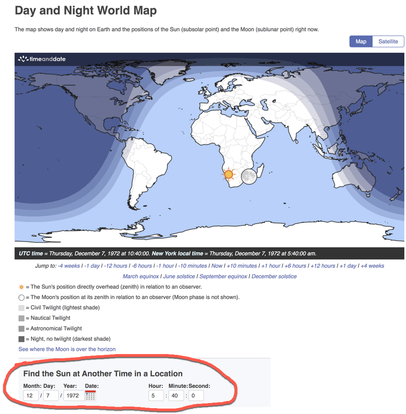
4. Timeanddate.com on day/night
We can track the sun and see if it lines up on with the Blue Marble image!
So here we are 7th Dec 1972, 10:39 UTC or 5:39 am EST
YES!!
Further you can verify the daylight of that exact day (further proof).
Thursday, December 7, 1972 at 5:40am New York
https://www.timeanddate.com/worldclock/sunearth.html
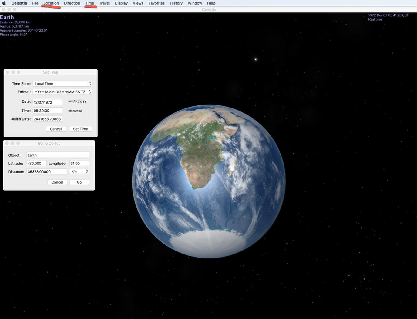
Celestia Recreation: Apollo 17 'Blue Marble', 7th Dec 1972 at 10:39 UTC, 29,000 km over 30°S 31°E
So here we are 7th Dec 1972, 10:39 UTC, about 29,000 km (18,000 miles) over about 30°S 31°E That's just an incredible level accuracy.
3. Proportions of Africa are too big. This is just perspective and we can use Celestia to see what it would look like at the known distance away.
This is just perspective and we can use Celestia to see what it would look like at the known distance away.
4. Should be night when it is showing day. This is due to online errors and if you get original flight logs you can pin the time down EXACTLY to 5:39AM EST or 10:39 UTC. Celestia accounts for time and will show darkness at night, and a terminator line.
Now 3 & 4 we can use Celestia to verify and you get the image here in the post. Amazing!
It's easy to see for yourself
1) Its Free (go to Celestia.com and download)
2) You can enter any distance from earth's surface and see the actual size as it would appear. (under location tab)
3) You can enter exact time and it will show day and night with terminator line. (under time tab)
To recreate the famous blue marble these are the relevant numbers.
So here we are 7th Dec 1972, 10:39 UTC, about 29,000 km (18,000 miles) over about 30°S 31°E
Celestia Recreation: Apollo 17 'Blue Marble',
Approximate Latitude -30 Longitude +31
Date and Time 7th Dec 1972 at 10:49 UTC, or 5:39 EST
Distance away is 29,000 kilometers but in Celestia it goes to the center of the earth you you have to add 6378 kilometers.
This only took me 5 minutes, Celestia makes it easy.
So this debunks two of the flat earth objections about size of Africa being too big and that it should be day. You can also verify this on timeanddate.com too!
|
|
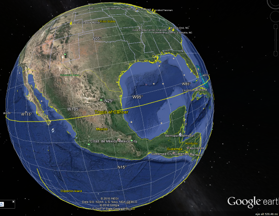
People often balk at this image but this is simply HOW the Earth looks from just 500 miles up, you only see a FRACTION of the Globe - you can recreate this in Google Earth. THIS IS HOW SPHERES WORK.
|
|
If you add all the weather satellite data from the past 20 years we have BILLIONS of images and hundreds of thousands of hours of video.
The idea that all of these are simple photoshop images or even the idea that there are millions of planes and balloons scouring the Earth every minute of the day and night so we get accurate image data we can render into globes is just absurd.
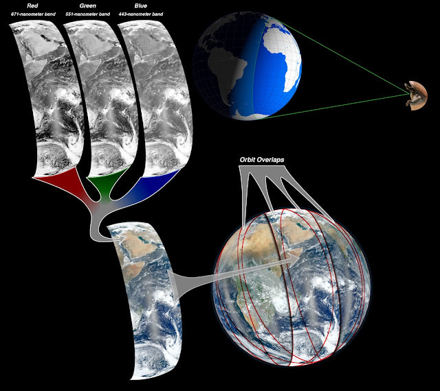
What Flat Earth is doing here to taking the fact that NASA themselves explained how they made SOME of the Blue Marble images FROM low-earth-orbit data (~500 miles up) and claiming that shows some grand conspiracy.
If NASA is "lying" why did THEY publish the details of how the images were put together?
The idea that all of these are simple photoshop images or even the idea that there are millions of planes and balloons scouring the Earth every minute of the day and night so we get accurate image data we can render into globes is just absurd.
What Flat Earth is doing here to taking the fact that NASA themselves explained how they made SOME of the Blue Marble images FROM low-earth-orbit data (~500 miles up) and claiming that shows some grand conspiracy.
If NASA is "lying" why did THEY publish the details of how the images were put together?
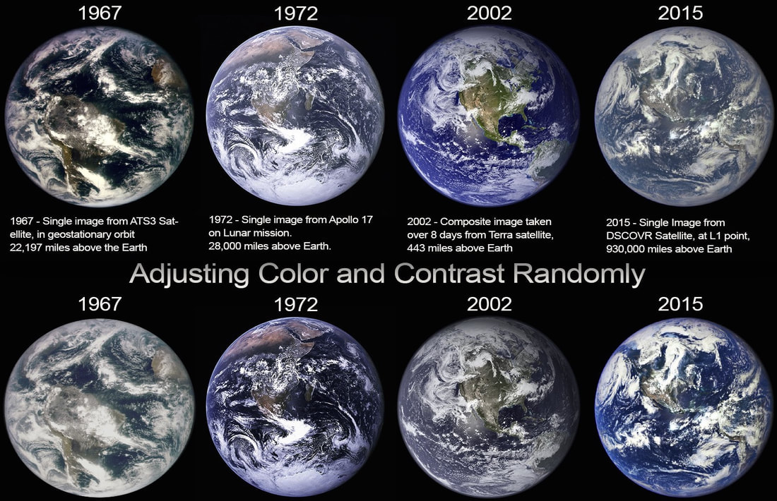
It's the same image, just adjusted to be more pleasing to the eye, in a similar way to what was done with the 2002 images.
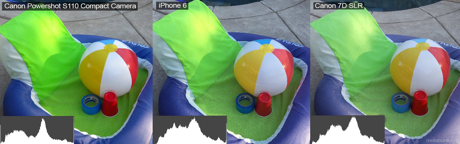
Different cameras take different images, which will vary in color and contrast. For example, here's there photos of the same scene with the same lighting, taken with three different cameras:
Different cameras take different images, which will vary in color and contrast. For example, here's there photos of the same scene with the same lighting, taken with three different cameras:
*** Tables Turned ***
"I am not believing the Earth is Flat until I see a Whole Disk Picture from high altitude."
I am waiting for a whole disk picture (non CGI) of the disk from space. The irony is flat earthers ONLY have CGI. Flat earthers demand whole spherical earth pictures from space but don't make the same demands on their own model. The truth is we have thousands of REAL non CGI composite and full spherical earth images from space from MANY space agencies, not just NASA.
I am waiting for just ONE flat earth disk picture, wall and all.
FEers, can you see the hyprocrisy here?? You demand from the us something we already have, and you yourself don't have anything!
Picture
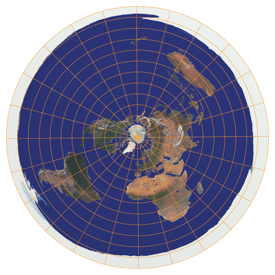
1. A map of the Earth looks like this.
The Earth is a circular disc, surrounded by an ice wall at Antarctica.
It seems to me that somebody once came across an Equidistant Azimuthal Projection of the Earth, and thought that this was the real thing! This map is indeed a legitimate projection of the spherical Earth, but that is all it is: a projection. I wonder if most naive flat earth believers realize the map the Flat earth priests share is a projection of the 3D earth we know onto 2 dimensions. Such a map will never have a scale of measurement because it will never be accurate for long distances being a 3D projection onto 2D.
This means of course that distances in what we call the southern hemisphere are wildly exaggerated, causing the speed of commercial aircraft to have to necessarily exceed twice the speed of sound in order to cover a flight like Sydney-Santiago in about 15 hours! Also we know Australia is not wider than the U.S.
"I am not believing the Earth is Flat until I see a Whole Disk Picture from high altitude."
I am waiting for a whole disk picture (non CGI) of the disk from space. The irony is flat earthers ONLY have CGI. Flat earthers demand whole spherical earth pictures from space but don't make the same demands on their own model. The truth is we have thousands of REAL non CGI composite and full spherical earth images from space from MANY space agencies, not just NASA.
I am waiting for just ONE flat earth disk picture, wall and all.
FEers, can you see the hyprocrisy here?? You demand from the us something we already have, and you yourself don't have anything!
Picture
1. A map of the Earth looks like this.
The Earth is a circular disc, surrounded by an ice wall at Antarctica.
It seems to me that somebody once came across an Equidistant Azimuthal Projection of the Earth, and thought that this was the real thing! This map is indeed a legitimate projection of the spherical Earth, but that is all it is: a projection. I wonder if most naive flat earth believers realize the map the Flat earth priests share is a projection of the 3D earth we know onto 2 dimensions. Such a map will never have a scale of measurement because it will never be accurate for long distances being a 3D projection onto 2D.
This means of course that distances in what we call the southern hemisphere are wildly exaggerated, causing the speed of commercial aircraft to have to necessarily exceed twice the speed of sound in order to cover a flight like Sydney-Santiago in about 15 hours! Also we know Australia is not wider than the U.S.
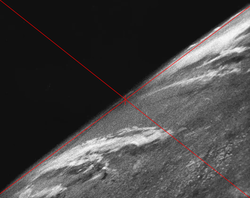
V2 rocket footage from 1946-1948
The V-2 No. 13[ was a modified V-2 rocket that became the first object to take a photograph of the Earth from outer space. Launched on 24 October 1946,[4] at the White Sands Missile Range in White Sands, New Mexico, the rocket reached a maximum altitude of 65 mi (105 km).
The V-2 No. 13[ was a modified V-2 rocket that became the first object to take a photograph of the Earth from outer space. Launched on 24 October 1946,[4] at the White Sands Missile Range in White Sands, New Mexico, the rocket reached a maximum altitude of 65 mi (105 km).
https://www.metabunk.org/threads/how-to-calculate-the-visible-fraction-of-the-earth-e-g-1972-blue-marble-apollo-17.8643/?fbclid=IwAR3eurVPUzwOqag15i4Dje1KkRmdhNPJG3X1DOOn2jaQ-mzhtwT_q2koUgE
Incredible Analysis
http://onebigmonkey.com/apollo/CATM/ch4/a17/ch4_9_1a.html
Incredible Analysis
http://onebigmonkey.com/apollo/CATM/ch4/a17/ch4_9_1a.html